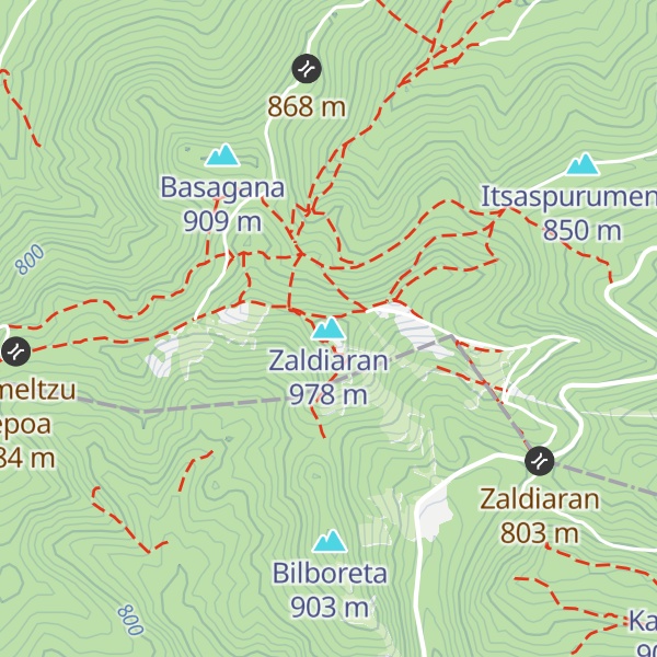
Zaldiaran (Spanish pronunciation: [θalˈdjaɾan], Basque pronunciation: [s̻aldi.aɾan]) is a mountain in the Montes de Vitoria range, in the province of Álava, Basque Country, Spain. Even if part of the south face of the mountain is on the Treviño exclave, Burgos; the summit itself lies in Álava. At the top of the mountain, apart from a tall metallic cross that was placed in 1950 by the Manuel Iradier hiking club, there are a few big aerials that transmit television and radio signal to Vitoria-Gasteiz.
Close to the summit lies the Zaldiaran pass, with a height of 780 metres (2,560 ft), it links Álava with the Treviño exclave. The roads that communicate the two provinces are the A-3102 in Álava and the BU-742 in Treviño. The northern slopes are covered by beeches (Fagus sylvatica) that give way to Portuguese oak (Quercus faginea) woods on the lower parts.
Due to the proximity of the summit to Vitoria-Gasteiz and its easy access, it is popular among hikers. On New Year's Day, the hiking clubs of the city organize hikes to the mountain to celebrate the new year.
We use GPS information embedded into the photo when it is available.
3D mountains overlay
Adjust mountain panorama to perfectly match your photos because recorded by camera photo position might be imprecise.
Move tool
Rotate tool
Zoom
More customization
Choose which peak labels should make into the final photo and what photo title should be.
Next
Photo Location
Satellitte
Flat map
Relief map
Latitude
Longitude
Altitude
OR
Latitude
°'''
Longitude
°'''
Apply
Register Peak
Peak Name
Latitude
Longitude
Altitude
Register
Teleport
PeakVisor
This 3D model of Sagarmatha National Park in Nepal was made using the PeakVisor app topographic data. The mobile app features higher precision models worldwide, more topographic details, and works offline. Download PeakVisor maps today.
Download OBJ model
PeakVisor
The download should start shortly. If you find it useful please consider supporting the PeakVisor app.
PeakVisor for iOS and Android
Be a superhero of outdoor navigation with state-of-the-art 3D maps and mountain identification in the palm of your hand!