Huaynaputina ( WY-nə-puu-TEE-nə; Spanish: [wajnapuˈtina]) is a volcano in a volcanic high plateau in southern Peru. Lying in the Central Volcanic Zone of the Andes, it was formed by the subduction of the oceanic Nazca Plate under the continental South American Plate. Huaynaputina is a large volcanic crater, lacking an identifiable mountain profile, with an outer stratovolcano and three younger volcanic vents within an amphitheatre-shaped structure that is either a former caldera or a remnant of glacial erosion. The volcano has erupted dacitic magma.
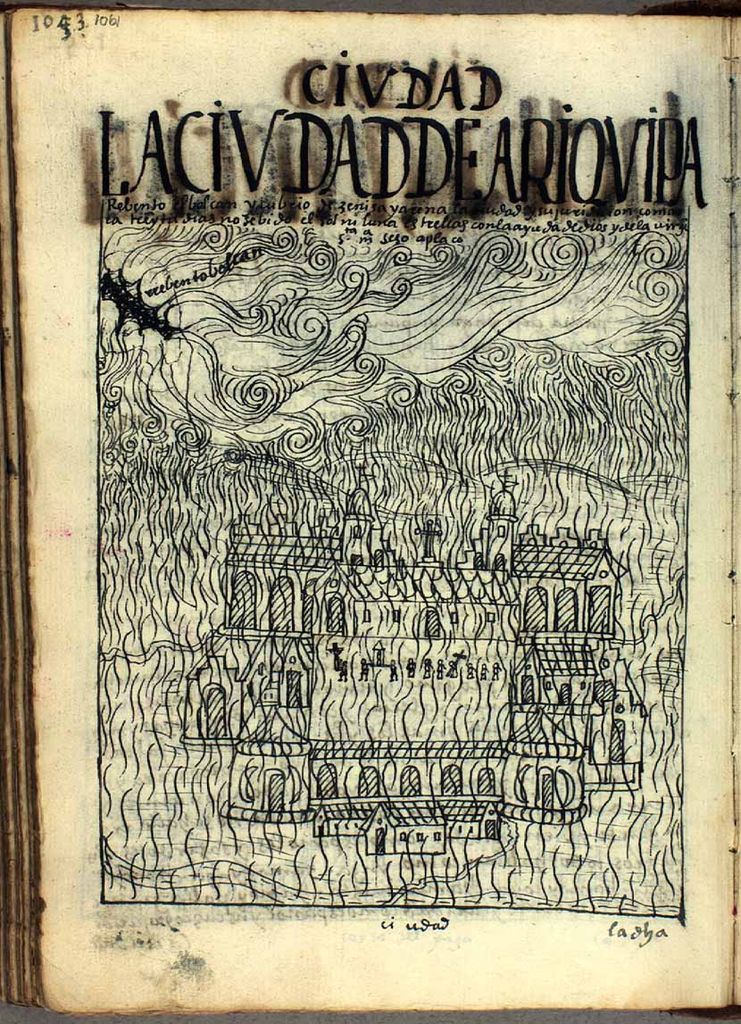
In the Holocene, Huaynaputina has erupted several times, including on 19 February 1600 – the largest eruption ever recorded in South America – which continued with a series of events into March. Witnessed by people in the city of Arequipa, it killed at least 1,000–1,500 people in the region, wiped out vegetation, buried the surrounding area with 2 metres (7 ft) of volcanic rock and damaged infrastructure and economic resources. The eruption had a significant impact on Earth's climate, causing a volcanic winter: temperatures in the Northern Hemisphere decreased; cold waves hit parts of Europe, Asia and the Americas; and the climate disruption may have played a role in the onset of the Little Ice Age. Floods, famines, and social upheavals resulted, including a probable link with the Russian Time of Troubles. This eruption has been computed to measure 6 on the Volcanic Explosivity Index (VEI).
The volcano has not erupted since 1600. There are fumaroles in the amphitheatre-shaped structure, and hot springs occur in the region, some of which have been associated with Huaynaputina. The volcano lies in a remote region where there is little human activity, but about 30,000 people live in the immediately surrounding area, and another one million in the Arequipa metropolitan area. If an eruption similar to the 1600 event were to occur, it would quite likely lead to a high death toll and cause substantial socioeconomic disruption. The Peruvian Geophysical Institute announced in 2017 that Huaynaputina would be monitored by the Southern Volcanological Observatory, and seismic observation began in 2019.
By elevation Volcán Huaynaputina (Ver Nevado Huaynaputina) is
# 60 out of 170 in General Sánchez Cerro
By prominence Volcán Huaynaputina (Ver Nevado Huaynaputina) is
We use GPS information embedded into the photo when it is available.
3D mountains overlay
Adjust mountain panorama to perfectly match your photos because recorded by camera photo position might be imprecise.
Move tool
Rotate tool
Zoom
More customization
Choose which peak labels should make into the final photo and what photo title should be.
Next
Photo Location
Satellitte
Flat map
Relief map
Latitude
Longitude
Altitude
OR
Latitude
°'''
Longitude
°'''
Apply
Register Peak
Peak Name
Latitude
Longitude
Altitude
Register
Teleport
PeakVisor
This 3D model of Sagarmatha National Park in Nepal was made using the PeakVisor app topographic data. The mobile app features higher precision models worldwide, more topographic details, and works offline. Download PeakVisor maps today.
Download OBJ model
PeakVisor
The download should start shortly. If you find it useful please consider supporting the PeakVisor app.
PeakVisor for iOS and Android
Be a superhero of outdoor navigation with state-of-the-art 3D maps and mountain identification in the palm of your hand!