Stromboli ( STROM-bə-lee, Italian: [ˈstromboli]; Sicilian: Struògnuli [ˈʂː(ɽ)wɔɲɲʊlɪ]) is an island in the Tyrrhenian Sea, off the north coast of Sicily, containing Mount Stromboli, one of the four active volcanoes in Italy. It is one of the seven Aeolian Islands, a volcanic arc north of Sicily, and the mythological home of Aeolus.
The island, with an area of 12.6 square kilometres (4.9 sq mi), represents the upper third of the volcano. Its population was about 500 as of 2016. The volcano has erupted many times and is constantly active with minor eruptions, often visible from many points on the island and from the surrounding sea, giving rise to the island's nickname "Lighthouse of the Mediterranean".
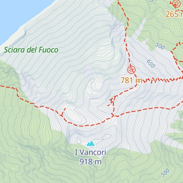
There's a demading hiking trail (T3) leading to the summit. Stromboli is one of the 1 peaks along the Stromboli Volcano trail.
By prominence Stromboli is
# 6 out of 3534 in Sicily # 3 out of 1006 in Messina
We use GPS information embedded into the photo when it is available.
3D mountains overlay
Adjust mountain panorama to perfectly match your photos because recorded by camera photo position might be imprecise.
Move tool
Rotate tool
Zoom
More customization
Choose which peak labels should make into the final photo and what photo title should be.
Next
Photo Location
Satellitte
Flat map
Relief map
Latitude
Longitude
Altitude
OR
Latitude
°'''
Longitude
°'''
Apply
Register Peak
Peak Name
Latitude
Longitude
Altitude
Register
Teleport
PeakVisor
This 3D model of Sagarmatha National Park in Nepal was made using the PeakVisor app topographic data. The mobile app features higher precision models worldwide, more topographic details, and works offline. Download PeakVisor maps today.
Download OBJ model
PeakVisor
The download should start shortly. If you find it useful please consider supporting the PeakVisor app.
PeakVisor for iOS and Android
Be a superhero of outdoor navigation with state-of-the-art 3D maps and mountain identification in the palm of your hand!


.jpg)