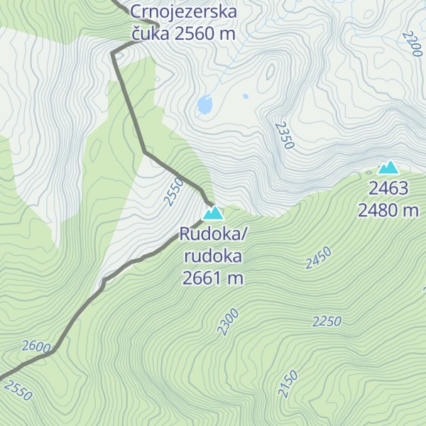
Velika Rudoka (Albanian: Maja e Njeriut, Rudoka e Madhe; Macedonian: Рудока, romanized: Rudoka; Serbian Cyrillic: Велика Рудока) is the highest peak of the Rudoka Mountain, situated in the Šar Mountains range, exactly on the border between Kosovo and North Macedonia. With the altitude of 2,660 metres (8,727 feet), it is the highest mountain of Kosovo, and also the highest mountain of Serbia according to the view held by the government of Serbia. In some older sources, the altitude was stated to be 2,658 metres, but newer measurements showed that the true altitude is 2 metres higher.
The Rudoka Mountain is situated between Šar Planina and Vrace, southwest of Tetovo. The mountain range lies in a southwest to northeasterly direction, neighbouring Borislavec. The eastern slopes are very steep. The western slopes lightly descend into Šar Planina. Few waters are present on the mountain and there are few valleys. Two lakes are on Rudoka: Crno jezero (Black lake) and Belo jezero (White lake). The Mazdrača, a stream which flows into the Vardar, has its source in Crno jezero.
It is a common misconception that the highest mountain in Kosovo is Gjeravica at 2,656 m (8,714 ft). This was stated even in the 2020 Statistical Yearbook of Serbia, and some Serbian schoolbooks. The 2021 edition of the Statistical Yearbook of Serbia corrected the info, naming Velika Rudoka the highest peak, as did the 2021 edition of the Geography schoolbook for Serbian elementary schools. The 2021 edition of the Statistical Yearbook of Kosovo still states that Gjeravica is the highest mountain. It has been known that Velika Rudoka is higher than Gjeravica since at least 1972, when the Topographical Map of Yugoslavia was published. According to Sava Stanković, PhD, the misconception started because of unclear boundaries between the Socialist Republic of Macedonia and the Socialist Republic of Serbia. The border was conclusively determined only after the breakup of Yugoslavia by a treaty between the Federal Republic of Yugoslavia and the Republic of Macedonia signed in Skopje on 23 February 2001.
We use GPS information embedded into the photo when it is available.
3D mountains overlay
Adjust mountain panorama to perfectly match your photos because recorded by camera photo position might be imprecise.
Move tool
Rotate tool
Zoom
More customization
Choose which peak labels should make into the final photo and what photo title should be.
Next
Photo Location
Satellitte
Flat map
Relief map
Latitude
Longitude
Altitude
OR
Latitude
°'''
Longitude
°'''
Apply
Register Peak
Peak Name
Latitude
Longitude
Altitude
Register
Teleport
PeakVisor
This 3D model of Sagarmatha National Park in Nepal was made using the PeakVisor app topographic data. The mobile app features higher precision models worldwide, more topographic details, and works offline. Download PeakVisor maps today.
Download OBJ model
PeakVisor
The download should start shortly. If you find it useful please consider supporting the PeakVisor app.
PeakVisor for iOS and Android
Be a superhero of outdoor navigation with state-of-the-art 3D maps and mountain identification in the palm of your hand!