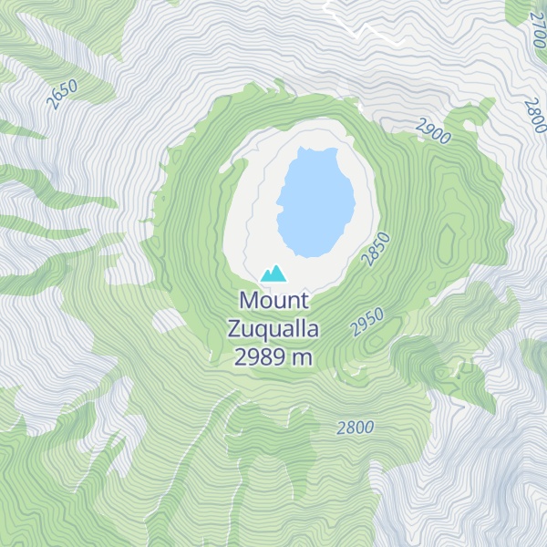
Mount Zuqualla (also spelled Zuquala, Zikwala or Chuqqaala) is an extinct volcano in the Oromia Region of Ethiopia. Situated in Ada'a Chukala woreda of the (East) Shewa Zone, it rises from the plain 30 kilometres (19 mi) south of Bishoftu. With a height of 2,989 metres (9,806 ft), it is known for its crater lake, lake Dembel, an elliptical crater lake with a maximum diameter of about one kilometre, but the trail around the crater is about 6 km long.
By elevation Mount Zuqualla is
# 32 out of 159 in the Entoto Mountains # 79 out of 566 in Oromia Region
By prominence Mount Zuqualla is
# 3 out of 159 in the Entoto Mountains # 9 out of 566 in Oromia Region # 28 out of 1895 in Ethiopia
We use GPS information embedded into the photo when it is available.
3D mountains overlay
Adjust mountain panorama to perfectly match your photos because recorded by camera photo position might be imprecise.
Move tool
Rotate tool
Zoom
More customization
Choose which peak labels should make into the final photo and what photo title should be.
Next
Photo Location
Satellitte
Flat map
Relief map
Latitude
Longitude
Altitude
OR
Latitude
°'''
Longitude
°'''
Apply
Register Peak
Peak Name
Latitude
Longitude
Altitude
Register
Teleport
PeakVisor
This 3D model of Sagarmatha National Park in Nepal was made using the PeakVisor app topographic data. The mobile app features higher precision models worldwide, more topographic details, and works offline. Download PeakVisor maps today.
Download OBJ model
PeakVisor
The download should start shortly. If you find it useful please consider supporting the PeakVisor app.
PeakVisor for iOS and Android
Be a superhero of outdoor navigation with state-of-the-art 3D maps and mountain identification in the palm of your hand!