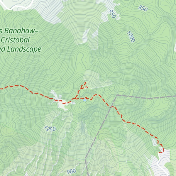
Mount San Cristobal is a potentially active stratovolcano at the boundary of the provinces of Laguna and Quezon on the island of Luzon, Philippines. The mountain rises to an elevation of 1,470 m (4,820 ft) above mean sea level and is one of the volcanic features of Macolod Corridor.
Mount San Cristobal is considered the Devil's Mountain in Filipino folklore. It is the alter-ego of the Holy Mountain, Mount Banahaw, and is part of Mounts Banahaw–San Cristobal Protected Landscape, covering 10,901 hectares (26,940 acres) of land.
The mountain is bordered by San Pablo in the province of Laguna at its northern slope and Dolores in the province of Quezon at its southern slope.
There's a hiking trail (T2) called to Mt. Cristobal summit;To Cristobal Summit leading to the summit.
The nearest mountain hut is Montelibano's House located 1 579m/5 181ft SE of the summit.
By elevation Mount San Cristobal is
# 3 out of 7 in Mount Banahaw and San Cristobal Protected Landscape # 1 out of 53 in Laguna # 1 out of 6 in San Pablo # 1 out of 4 in Rizal
By prominence Mount San Cristobal is
# 2 out of 7 in Mount Banahaw and San Cristobal Protected Landscape # 2 out of 53 in Laguna # 1 out of 6 in San Pablo # 1 out of 4 in Rizal
We use GPS information embedded into the photo when it is available.
3D mountains overlay
Adjust mountain panorama to perfectly match your photos because recorded by camera photo position might be imprecise.
Move tool
Rotate tool
Zoom
More customization
Choose which peak labels should make into the final photo and what photo title should be.
Next
Photo Location
Satellitte
Flat map
Relief map
Latitude
Longitude
Altitude
OR
Latitude
°'''
Longitude
°'''
Apply
Register Peak
Peak Name
Latitude
Longitude
Altitude
Register
Teleport
PeakVisor
This 3D model of Sagarmatha National Park in Nepal was made using the PeakVisor app topographic data. The mobile app features higher precision models worldwide, more topographic details, and works offline. Download PeakVisor maps today.
Download OBJ model
PeakVisor
The download should start shortly. If you find it useful please consider supporting the PeakVisor app.
PeakVisor for iOS and Android
Be a superhero of outdoor navigation with state-of-the-art 3D maps and mountain identification in the palm of your hand!