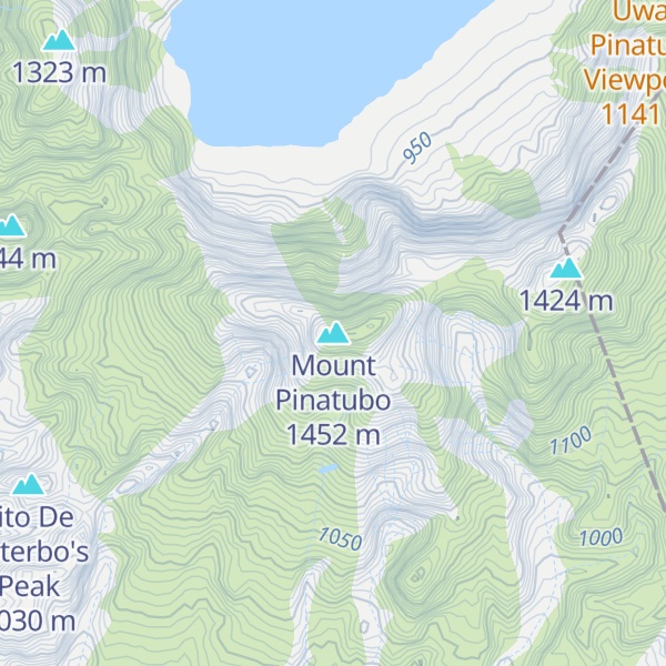
Mount Pinatubo is an active stratovolcano in the Zambales Mountains in Luzon island of the Philippines. Located on the tripoint of Zambales, Tarlac and Pampanga provinces, most people were unaware of its eruptive history before the pre-eruption volcanic activity in early 1991. Dense forests, which supported a population of several thousand indigenous Aetas, heavily eroded and obscured Pinatubo.
Pinatubo is known for its VEI-6 eruption on June 15, 1991, the second-largest terrestrial eruption of the 20th century after the 1912 eruption of Novarupta in Alaska. The eruption coincided with Typhoon Yunya making landfall in the Philippines, which brought a dangerous mix of ash and rain to nearby towns and cities. Early predictions led to the evacuation of tens of thousands of people, saving many lives. The eruption severely damaged surrounding areas with pyroclastic surges, pyroclastic falls, and later, flooding lahars caused by rainwater re-mobilizing volcanic deposits. This destruction affected infrastructure and altered river systems for years. Minor dome-forming eruptions inside the caldera continued from 1992 to 1993.
The 1991 eruption had worldwide effects. It released roughly 10 billion tonnes (1.1×10¹⁰ short tons) or 10 km3 (2.4 cu mi) of magma, and 20 million tonnes (22 million short tons) of SO2, bringing large amounts of minerals and toxic metals to the surface. It ejected more particulate into the stratosphere than any eruption since Krakatoa in 1883. In the following months, aerosols formed a global layer of sulfuric acid haze. Global temperatures dropped by about 0.5 °C (0.9 °F) in the years 1991–1993, and ozone depletion temporarily increased significantly.
We use GPS information embedded into the photo when it is available.
3D mountains overlay
Adjust mountain panorama to perfectly match your photos because recorded by camera photo position might be imprecise.
Move tool
Rotate tool
Zoom
More customization
Choose which peak labels should make into the final photo and what photo title should be.
Next
Photo Location
Satellitte
Flat map
Relief map
Latitude
Longitude
Altitude
OR
Latitude
°'''
Longitude
°'''
Apply
Register Peak
Peak Name
Latitude
Longitude
Altitude
Register
Teleport
PeakVisor
This 3D model of Sagarmatha National Park in Nepal was made using the PeakVisor app topographic data. The mobile app features higher precision models worldwide, more topographic details, and works offline. Download PeakVisor maps today.
Download OBJ model
PeakVisor
The download should start shortly. If you find it useful please consider supporting the PeakVisor app.
PeakVisor for iOS and Android
Be a superhero of outdoor navigation with state-of-the-art 3D maps and mountain identification in the palm of your hand!


.jpg)
.jpg)