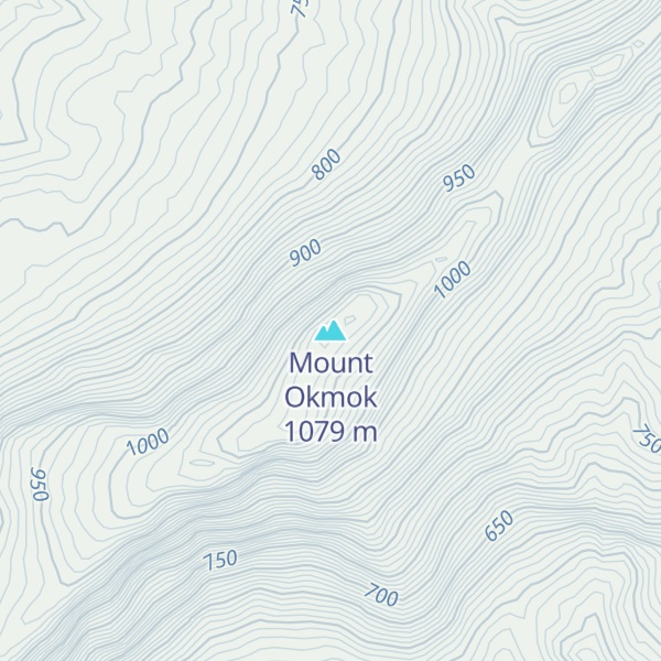
Mount Okmok is a volcano on eastern Umnak Island, in the central-eastern Aleutian Islands of Alaska. Part of the Aleutian Volcanic Arc, it was formed by the subduction of the oceanic Pacific Plate under the North American Plate. Okmok is a large shield volcano capped by a 10-kilometer (6.2 mi) wide caldera. The caldera contains numerous cinder cones, their lava flows, and a few lakes. Okmok erupts mainly basaltic lava, mostly from the cones within the caldera.
Activity began in the Pleistocene. Two large caldera-forming eruptions took place during the Holocene, with a volcanic explosivity index (VEI) of 6; the second of these occurred in 43 BCE and caused a volcanic winter that might have changed the history of Egypt. After this second caldera-forming eruption a crater lake formed in the caldera, and drained in one of the largest known floods of the Holocene. Okmok is one of the most active volcanoes of North America; numerous eruptions have produced lava flows within the caldera, and the 1817 eruption destroyed an Aleut village.
The last eruption was in 2008 and produced several new vents in the caldera. This eruption, which occurred with little forewarning, yielded a volcanic cloud that produced volcanic ash fall around Okmok. The volcano is monitored by the Alaska Volcano Observatory (AVO).
We use GPS information embedded into the photo when it is available.
3D mountains overlay
Adjust mountain panorama to perfectly match your photos because recorded by camera photo position might be imprecise.
Move tool
Rotate tool
Zoom
More customization
Choose which peak labels should make into the final photo and what photo title should be.
Next
Photo Location
Satellitte
Flat map
Relief map
Latitude
Longitude
Altitude
OR
Latitude
°'''
Longitude
°'''
Apply
Register Peak
Peak Name
Latitude
Longitude
Altitude
Register
Teleport
PeakVisor
This 3D model of Sagarmatha National Park in Nepal was made using the PeakVisor app topographic data. The mobile app features higher precision models worldwide, more topographic details, and works offline. Download PeakVisor maps today.
Download OBJ model
PeakVisor
The download should start shortly. If you find it useful please consider supporting the PeakVisor app.
PeakVisor for iOS and Android
Be a superhero of outdoor navigation with state-of-the-art 3D maps and mountain identification in the palm of your hand!