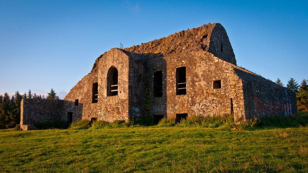
Montpelier Hill (Irish: Cnoc Montpelier) is a 383-metre (1,257 foot) hill in County Dublin, Ireland. It is topped by the Hell Fire Club (Irish: Club Thine Ifreann), the popular name given to the ruined building. This building – an occasional summer residence built in around 1725 by William Conolly – was originally called Mount Pelier and since its construction the hill has also gone by the same name. The building and hill were respectively known locally as 'The Brass Castle' and 'Bevan's Hill', but the original Irish name of the hill is no longer known although the historian and archaeologist Patrick Healy has suggested that the hill is the place known as Suide Uí Ceallaig or Suidi Celi in the Crede Mihi, the twelfth-century diocesan register book of the Archbishops of Dublin.
Montpelier is the closest to Dublin city of the group of mountains – along with Killakee, Featherbed Bog, Kippure, Seefingan, Corrig, Seahan, Ballymorefinn, Carrigeenoura, and Slievenabawnogue – that form the ridge that bounds the Glenasmole valley. On the slopes is a forestry plantation, known as Hell Fire Wood, which consists of Sitka spruce, larch and beech.
Originally there was a cairn with a prehistoric passage grave on the summit. Stones from the cairn were taken and used in the construction of the Mount Pelier summer residence. Shortly after completion, a storm blew the roof off. Local superstition attributed this incident to the work of the Devil, a punishment for interfering with the cairn. Montpelier Hill has since become associated with numerous paranormal events.
Members of the Irish Hell Fire Club, which was active in the years 1735 to 1741, used Mount Pelier summer residence as a meeting place. Stories of wild behaviour and debauchery and occult practices and demonic manifestations have become part of the local lore over the years. The original name of the summer residence has been displaced and the building is generally known as the Hell Fire Club. When the residence was damaged by fire, the members of the Hell Fire Club relocated down the hill to the nearby Stewards House for a brief period. This building also has a reputation for being haunted, most notably by a massive black cat.
Adjacent to the Stewards House are the remains of Killakee Estate. A large Victorian house was built here in the early nineteenth century by Luke White. White's son, Samuel, oversaw the development of extensive formal gardens on the estate, including the construction of several glasshouses by Richard Turner. The estate passed to the Massy family through inheritance in 1880 and John Thomas Massy, the 6th Baron made extensive use of the house and ground to host shooting parties and society gatherings. The fortunes of the Massy family declined in the early twentieth century and Hamon Massy, the 8th Baron, was evicted from Killakee House in 1924. He became known as the "Penniless Peer". Following the eviction, Killakee House was demolished and the gardens fell into ruin.
Today Montpelier Hill and much of the surrounding lands, including Killakee Estate (now called Lord Massy's Estate) are owned by the State forestry company Coillte and are open to the public.
We use GPS information embedded into the photo when it is available.
3D mountains overlay
Adjust mountain panorama to perfectly match your photos because recorded by camera photo position might be imprecise.
Move tool
Rotate tool
Zoom
More customization
Choose which peak labels should make into the final photo and what photo title should be.
Next
Photo Location
Satellitte
Flat map
Relief map
Latitude
Longitude
Altitude
OR
Latitude
°'''
Longitude
°'''
Apply
Register Peak
Peak Name
Latitude
Longitude
Altitude
Register
Teleport
PeakVisor
This 3D model of Sagarmatha National Park in Nepal was made using the PeakVisor app topographic data. The mobile app features higher precision models worldwide, more topographic details, and works offline. Download PeakVisor maps today.
Download OBJ model
PeakVisor
The download should start shortly. If you find it useful please consider supporting the PeakVisor app.
PeakVisor for iOS and Android
Be a superhero of outdoor navigation with state-of-the-art 3D maps and mountain identification in the palm of your hand!