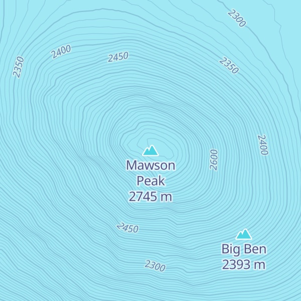
Mawson Peak is an active volcanic summit of the Big Ben massif on Heard Island, an external Australian territory in the Indian Ocean.
With an elevation of 2,745 metres (9,006 ft), it is the third highest peak in any state, territory or claimed territory of Australia, higher than the 2,228-metre (7,310 ft) Mount Kosciuszko, and surpassed only by the 3,490-metre (11,450 ft) Mount McClintock and the 3,355-metre (11,007 ft) Mount Menzies in the Australian Antarctic Territory. The Australian Antarctic Territory is a territorial claim unrecognised by most other countries, meaning that Mawson Peak is the highest mountain over which Australia has true sovereignty. The peak erupts fairly frequently, and as recently as May 2023. Mawson Peak is ranked the 30th of Earth's most topographically isolated summits.
By elevation Mawson Peak is
# 1 out of 29 in Heard Island and McDonald Islands # 1 out of 21731 in Australia # 1 out of 29 in Heard and McDonald Islands World Heritage Area # 1 out of 29 in Heard Island and McDonald Islands Marine Reserve
By prominence Mawson Peak is
# 1 out of 29 in Heard Island and McDonald Islands # 1 out of 21731 in Australia # 1 out of 29 in Heard and McDonald Islands World Heritage Area # 1 out of 29 in Heard Island and McDonald Islands Marine Reserve
We use GPS information embedded into the photo when it is available.
3D mountains overlay
Adjust mountain panorama to perfectly match your photos because recorded by camera photo position might be imprecise.
Move tool
Rotate tool
Zoom
More customization
Choose which peak labels should make into the final photo and what photo title should be.
Next
Photo Location
Satellitte
Flat map
Relief map
Latitude
Longitude
Altitude
OR
Latitude
°'''
Longitude
°'''
Apply
Register Peak
Peak Name
Latitude
Longitude
Altitude
Register
Teleport
PeakVisor
This 3D model of Sagarmatha National Park in Nepal was made using the PeakVisor app topographic data. The mobile app features higher precision models worldwide, more topographic details, and works offline. Download PeakVisor maps today.
Download OBJ model
PeakVisor
The download should start shortly. If you find it useful please consider supporting the PeakVisor app.
PeakVisor for iOS and Android
Be a superhero of outdoor navigation with state-of-the-art 3D maps and mountain identification in the palm of your hand!