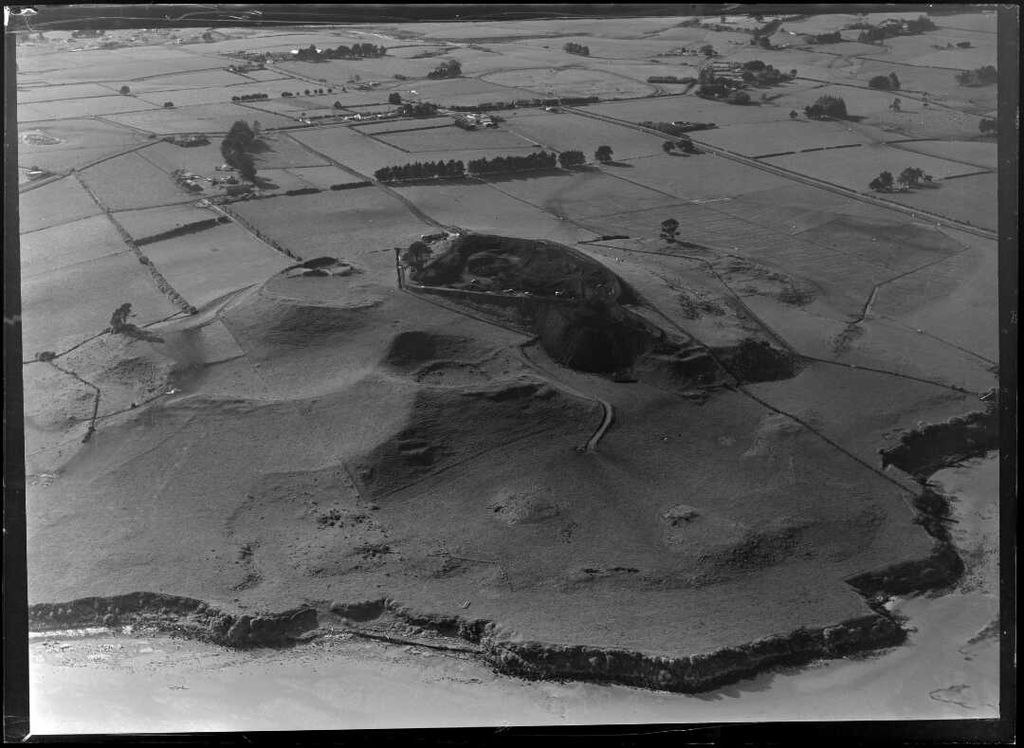
Maungataketake (also Ellett's Mount) is one of the volcanoes in the Auckland volcanic field in New Zealand. It had a 76 m high scoria cone, beside a 100 m wide crater, before they were quarried away. It was the site of a pā. Layers of volcanic tuff and ash from Maungataketake overlay the fallen trunks of the nearby Ihumātao fossil forest. The New Zealand Ministry for Culture and Heritage gives a translation of "broad mountain" for Maungataketake.
The volcano erupted an estimated 90,000 years before the present. Maungataketake was one of the earliest archaeological sites in New Zealand, with charcoal samples dating to the Archaic period of Māori history. Extensive stone gardens were built by Tāmaki Māori at Maungataketake, Ōtuataua and Ihumātao in the mid-1400s. In the early 1700s, Maungataketake was one of the major defensive pā during the Waiohua confederacy era.
In December 1862, the Ellett family purchased land from the former Wesleyan Mission at Ihumātao. Their association with the area led to the name Ellett's Mount for the volcano. In 1866, ownership of Maungataketake and Ihumātao was returned to Apihai Te Kawau, chief of Ngāti Whātua in Auckland, after the land confiscations instigated during the Invasion of the Waikato.
From September 1962, the volcanic cone was quarried for construction materials in the creation of Auckland Airport.
We use GPS information embedded into the photo when it is available.
3D mountains overlay
Adjust mountain panorama to perfectly match your photos because recorded by camera photo position might be imprecise.
Move tool
Rotate tool
Zoom
More customization
Choose which peak labels should make into the final photo and what photo title should be.
Next
Photo Location
Satellitte
Flat map
Relief map
Latitude
Longitude
Altitude
OR
Latitude
°'''
Longitude
°'''
Apply
Register Peak
Peak Name
Latitude
Longitude
Altitude
Register
Teleport
PeakVisor
This 3D model of Sagarmatha National Park in Nepal was made using the PeakVisor app topographic data. The mobile app features higher precision models worldwide, more topographic details, and works offline. Download PeakVisor maps today.
Download OBJ model
PeakVisor
The download should start shortly. If you find it useful please consider supporting the PeakVisor app.
PeakVisor for iOS and Android
Be a superhero of outdoor navigation with state-of-the-art 3D maps and mountain identification in the palm of your hand!