Mount Muria or Gunung Muria is a dormant stratovolcano type mountain on the north coast of Central Java, Indonesia, about 66 km north of Semarang City. It falls between three Regencies: Jepara on the west, Kudus on the south, and Pati on the east. Some sources state the mountain has a height of 1602 m, some state 1625 m.
Mount Muria was once an island, separated from Java by the Muria Strait. The strait was one of the spice trade routes connecting the Middle East with Maluku and was probably traveled by Tomé Pires on his voyage to Java. The strait closed around 1657.: 111–113
In 1979, the northern side of the mountain was chosen by the National Nuclear Energy Agency (BATAN) [id] as a location for the construction of a nuclear power plant, with the understanding that the risk of earthquakes and volcanic eruptions were small compared to other parts of Java and Bali. The plant's placement also took into consideration electricity consumption in Central Java. Earthquakes that rocked Mount Muria in the 2010s put an end to the development plan.
The mountain last erupted in 160 BCE.
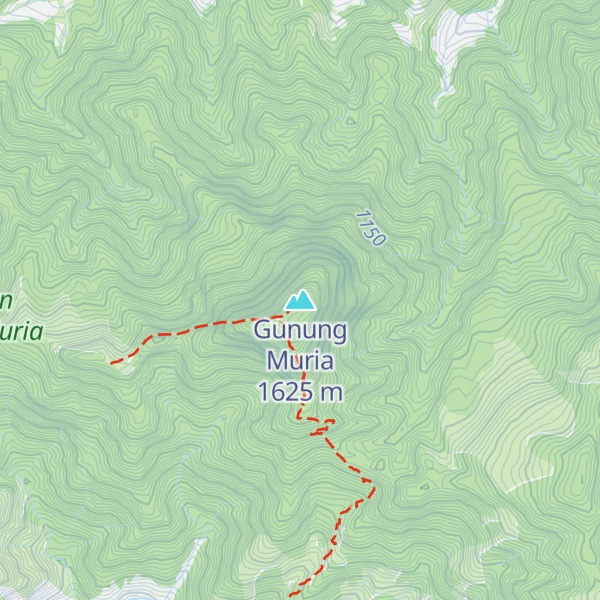
There's a trail called Jalur Pendakian Puncak 29 Via Desa Rahtawu leading to the summit. Gunung Muria is one of the 2 peaks along the Pendakian P.
The nearest mountain hut is null located 39m/128ft NNE of the summit.
By elevation Gunung Muria is
# 96 out of 1943 in Central Java
By prominence Gunung Muria is
# 6 out of 1943 in Central Java # 74 out of 27724 in Indonesia # 70 out of 30908 in the Malay Archipelago Mountains
We use GPS information embedded into the photo when it is available.
3D mountains overlay
Adjust mountain panorama to perfectly match your photos because recorded by camera photo position might be imprecise.
Move tool
Rotate tool
Zoom
More customization
Choose which peak labels should make into the final photo and what photo title should be.
Next
Photo Location
Satellitte
Flat map
Relief map
Latitude
Longitude
Altitude
OR
Latitude
°'''
Longitude
°'''
Apply
Register Peak
Peak Name
Latitude
Longitude
Altitude
Register
Teleport
PeakVisor
This 3D model of Sagarmatha National Park in Nepal was made using the PeakVisor app topographic data. The mobile app features higher precision models worldwide, more topographic details, and works offline. Download PeakVisor maps today.
Download OBJ model
PeakVisor
The download should start shortly. If you find it useful please consider supporting the PeakVisor app.
PeakVisor for iOS and Android
Be a superhero of outdoor navigation with state-of-the-art 3D maps and mountain identification in the palm of your hand!