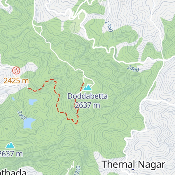
Doddabetta (Tamil pronunciation: [toʈːabeʈːaː]) is the highest mountain in the Nilgiri Mountains at 2,637 metres (8,652 ft). There is a reserved forest area around the peak. It is 9 km from Ooty, on the Ooty-Kotagiri Road in the Nilgiris District of Tamil Nadu, India. It is a popular tourist attraction with road access to the summit. It is the fourth highest peak in South India next to Anamudi, Mannamalai and Meesapulimala. The peaks Hecuba (2375 m), Kattadadu (2418 m) and Kulkudi (2439 m) are the three closely linked summits in the west of the Doddabetta range near to Udagamandalam. The word Doddabetta is derived from Kannada, meaning 'big hill'.
There's a trail leading to the summit.
By elevation Doddabetta is
# 1 out of 1529 in the Western Ghats # 1 out of 27 in Udhagamandalam # 3 out of 1381 in Tamil Nadu
By prominence Doddabetta is
# 1 out of 1529 in the Western Ghats # 1 out of 27 in Udhagamandalam # 8 out of 13857 in India # 1 out of 1381 in Tamil Nadu
We use GPS information embedded into the photo when it is available.
3D mountains overlay
Adjust mountain panorama to perfectly match your photos because recorded by camera photo position might be imprecise.
Move tool
Rotate tool
Zoom
More customization
Choose which peak labels should make into the final photo and what photo title should be.
Next
Photo Location
Satellitte
Flat map
Relief map
Latitude
Longitude
Altitude
OR
Latitude
°'''
Longitude
°'''
Apply
Register Peak
Peak Name
Latitude
Longitude
Altitude
Register
Teleport
PeakVisor
This 3D model of Sagarmatha National Park in Nepal was made using the PeakVisor app topographic data. The mobile app features higher precision models worldwide, more topographic details, and works offline. Download PeakVisor maps today.
Download OBJ model
PeakVisor
The download should start shortly. If you find it useful please consider supporting the PeakVisor app.
PeakVisor for iOS and Android
Be a superhero of outdoor navigation with state-of-the-art 3D maps and mountain identification in the palm of your hand!