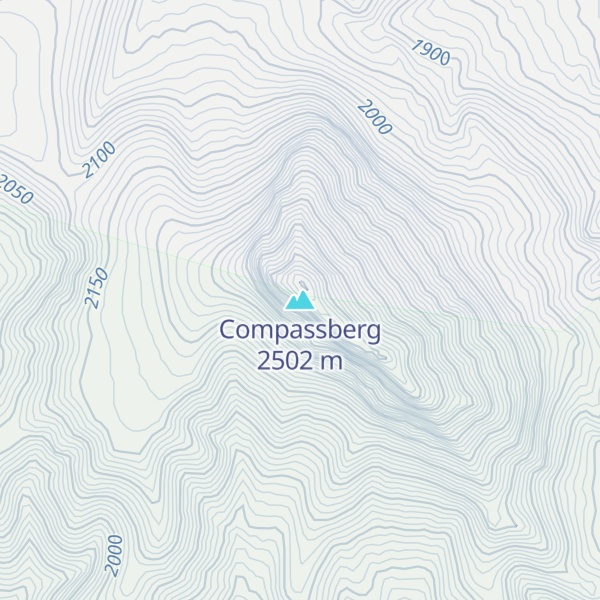
Compassberg (Afrikaans: Kompasberg), is a mountain peak of the Sneeuberge range in South Africa. It is located 55 km due north of Graaff-Reinet in the Eastern Cape Province. At 2504 metres, it is the highest peak in South Africa outside the Stormberg-Drakensberg massif. It was named by Colonel Robert Jacob Gordon when he accompanied Governor Joachim van Plettenberg on a journey to the eastern frontier of the Cape Colony in 1778.
The mountain is composed of sediments of the Beaufort Series in the Karoo System, and extensively intruded by dolerite dikes and sills.
By elevation Compassberg is
# 95 out of 14201 in South Africa # 1 out of 637 in Sarah Baartman District Municipality # 1 out of 463 in Chris Hani District Municipality # 40 out of 2032 in Eastern Cape # 1 out of 186 in the Swartberg
By prominence Compassberg is
# 23 out of 14201 in South Africa # 2 out of 637 in Sarah Baartman District Municipality # 2 out of 463 in Chris Hani District Municipality # 3 out of 2032 in Eastern Cape # 1 out of 186 in the Swartberg
We use GPS information embedded into the photo when it is available.
3D mountains overlay
Adjust mountain panorama to perfectly match your photos because recorded by camera photo position might be imprecise.
Move tool
Rotate tool
Zoom
More customization
Choose which peak labels should make into the final photo and what photo title should be.
Next
Photo Location
Satellitte
Flat map
Relief map
Latitude
Longitude
Altitude
OR
Latitude
°'''
Longitude
°'''
Apply
Register Peak
Peak Name
Latitude
Longitude
Altitude
Register
Teleport
PeakVisor
This 3D model of Sagarmatha National Park in Nepal was made using the PeakVisor app topographic data. The mobile app features higher precision models worldwide, more topographic details, and works offline. Download PeakVisor maps today.
Download OBJ model
PeakVisor
The download should start shortly. If you find it useful please consider supporting the PeakVisor app.
PeakVisor for iOS and Android
Be a superhero of outdoor navigation with state-of-the-art 3D maps and mountain identification in the palm of your hand!