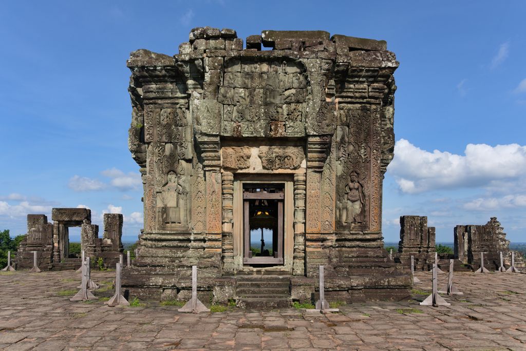
Phnom Bakheng (Khmer: ភ្នំបាខែង [pʰnom baːkʰaeŋ]) is a Hindu temple in the form of a temple mountain in Siem Reap Province, Cambodia. Dedicated to Shiva, it was built at the end of the 9th century, during the reign of King Yasovarman (889–910). Located atop a hill, it is nowadays a popular tourist spot for sunset views of the much bigger temple Angkor Wat, which lies amid the jungle about 1.5 km to the southeast. The large number of visitors makes Phnom Bakheng one of the most threatened monuments of Angkor. Since 2004, World Monuments Fund has been working to conserve the temple in partnership with APSARA.
History
Phnom Bakheng, built more than two centuries before Angkor Wat, was once the main temple in the Angkor region. It was the central architectural feature of a new capital called Yasodharapura, established by Yasovarman when he moved the court from the old capital, Hariharalaya, in the southeast Roluos area.
An inscription dated 1052 AD and found at the Sdok Kak Thom temple in present-day Thailand states in Sanskrit: "When Sri Yasovardhana became king under the name of Yasovarman, the able Vamasiva continued as his guru. By the king's order, he set up a linga on Sri Yasodharagiri, a mountain equal in beauty to the king of mountains." Scholars believe that this passage refers to the consecration of the Phnom Bakheng temple approximately a century and a half earlier.
Phnom Bakheng is one of 3 hilltop temples in the Angkor region that are attributed to Yasovarman's reign. The other two are Phnom Krom to the south near the Tonle Sap lake, and Phnom Bok, northeast of the East Baray reservoir.
Workers built a protective outer moat around the mountain and temple. There were avenues extending in the north, south, east, and west directions from the mountain. A raised pathway, first going northwest to southeast from the old capital to the new capital's outer moat, and then turning to go east to west, connected directly to the east entrance of the temple.
Later in its history, Phnom Bakheng was converted into a Buddhist temple. A monumental Sitting Buddha, now lost, was created on its upper tier. Across its west side, a Reclining Buddha of similar scale was crafted in stone. The outlines of this figure are still visible.
We use GPS information embedded into the photo when it is available.
3D mountains overlay
Adjust mountain panorama to perfectly match your photos because recorded by camera photo position might be imprecise.
Move tool
Rotate tool
Zoom
More customization
Choose which peak labels should make into the final photo and what photo title should be.
Next
Photo Location
Satellitte
Flat map
Relief map
Latitude
Longitude
Altitude
OR
Latitude
°'''
Longitude
°'''
Apply
Register Peak
Peak Name
Latitude
Longitude
Altitude
Register
Teleport
PeakVisor
This 3D model of Sagarmatha National Park in Nepal was made using the PeakVisor app topographic data. The mobile app features higher precision models worldwide, more topographic details, and works offline. Download PeakVisor maps today.
Download OBJ model
PeakVisor
The download should start shortly. If you find it useful please consider supporting the PeakVisor app.
PeakVisor for iOS and Android
Be a superhero of outdoor navigation with state-of-the-art 3D maps and mountain identification in the palm of your hand!