
Scan the QR code and open PeakVisor on your phone
"The Call of the Tiger" National Park has 16 named peaks. The highest is Gora Oblachnaya at 1,860 m. Other notable peaks include Snezhnaya, Gora Sestra and Bastion I Zhuzha-park.
The Call of the Tiger National Park is one of the youngest parks in Russia, founded on June 2, 2007. The main purpose was to preserve and restore the endangered species included in the Red Book of Russia and IUCN Red Book. Among them are 6 mammal species, but the starring one is the largest tiger and the most perfect predator in the world - the Amur tiger. The park runs a special programme on conserving the population of the Amur tiger. The park also develops and implements scientific methods of nature protection, carries out environmental monitoring, and creates conditions for tourism and recreation. The park is located in the south-east of the Primorsky Territory and occupies lands of three districts: the Lazovsky, the Olginsky, and the Chuguevsky.

The territory of the national park includes the southern section of the Sikhote Alin Range, the mountain system of Mount Oblachnaya, the upper reaches of the basin of the rivers Milogradovka, Ussuri and, partly the Kievka River. The area is 8,2152 ha, the length from north to south is 42 km, from west to east is 39 km. The relief is mountainous.
The climate is monsoon. Geographical location, unique climate features and the fact that in the millions of years the territory of the Southern Primorsky Territory has not been subject to the cover glaciation generated the unique diversity of flora. Modern plant species and representatives of the most ancient flora create exceptional landscapes. Outstanding mountain peaks, bizarre rocks, waterfalls, centuries-old trees with massive trunks will make a lasting impression on anyone.
The climate of the national park is monsoon with pronounced continental features. It is much milder in the southern part of the park than in the northern one. In July-August, the air warms up to + 30-36°C (86-97F). The average temperature in January is minus 17-18°C (1F). Snowfall is highest in March (about 25 mm). On the forested slopes of the mountains, the snow cover reaches 50 cm.

Since the Call of the Tiger National Park is quite young, species lists of plants have not yet been fully compiled, but general regularities of forming plant communities are described. Taking into account the mountainous nature of the relief and the great height differences, the park's territory is characterized by an amazing biological diversity of flora, which has no equal counterparts in the whole world.
Most of the area of the park is occupied by forests. Cedar-broadleaved, birch, spruce and fir, oak and mountain tundra forests are common here.
Siberian cedar and Amur cork tree, a perennial deciduous tree, are among the dominant tree species. Two species of larch are almost universally found here – the Olginskaya larch (Larix olgensis), which is among the vulnerable species, and Komarova’s larch (Larix komarovii).

When you are walking through those Far Eastern forests, it feels like you have embarked on an amazing journey into the fairy tale lands. The vines wrap around the trees: Chinese lemongrass, Amur grapes, Actinidia. Their berries are not only beautiful but also very useful. For example, Chinese lemongrass has been used in folk medicine since ancient times as a rich source of vitamins, it is also considered to be a powerful immunomodulatory agent.
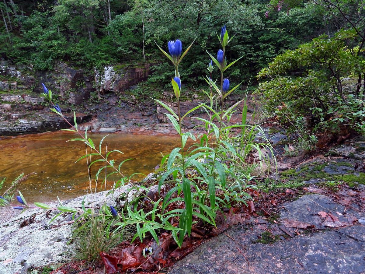
Among the huge variety of plants, there are many flowering ones, you can see beautiful pink peonies, lilies, ladies’ slippers, rhododendrons and other beautiful and rare plants that need protection.
High in the mountains grows the devil’s club (Echinopanax elatum), a close relative of ginseng. The potions made from its roots increase blood pressure, stimulate the central nervous system, and cure depression. There are approximately 400 species of lichens in this area. One of them is Peltigera lichen, it grows on sunny meadows or near roads, its wide and very thin plates of steel colour take the most bizarre shapes.
The national park is home to almost all rare, endemic and valuable fauna species of the southern parts of the Far East. Officially, there have been registered 54 species. During the critical periods of decline in the number of many species, this area served as a centre of conservation and restoration of species. Among the usual representatives of large mammals living here are: the Himalayan and brown bear, Manchurian deer (aka Siberian stag or maral), wild boar, European roe deer, musk deer.
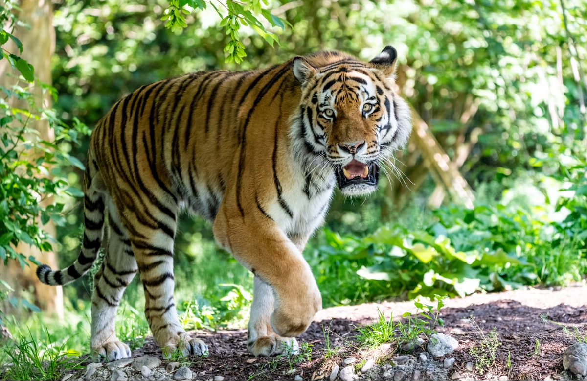
Among the inhabitants listed in the Red Book of Russia is the Amur tiger, the Ussurian spotted deer, ghoral, Far Eastern leopard, and red wolf. The leopard and the red wolf were quite a common sight here 20 years ago, but now there is no data even on occasional spotting of those predators.
The Amur tiger and the Far Eastern forest cat deserve special attention. An ancient legend of the Udege peoples says, "At the sunset of their days, tigers go to die on top of the sacred mountain. This is the law of the Creator of all things alive". It is difficult to challenge this legend because nobody has ever seen in the taiga the corpse of an Amur tiger who died naturally. Scientists cannot find the sacred tiger mountain, and the native inhabitants, even under the fear of death, will not disturb the spirit of the master of the taiga. For the local indigenous people, the Amur tiger is a deity, respected and feared.
The bird realm of the national park is also very diverse. There are 238 bird species, over 100 of them are nesting. Among the rare and endemic species are the white-tailed sea eagle, black stork, scaly-sided merganser, hawk owl, black-headed nuthatch, fish owl, honey hawk, fish eagle, mandarin duck and others.
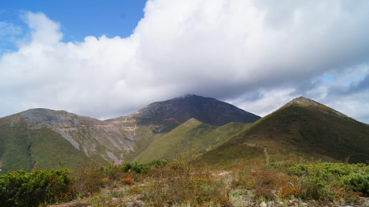
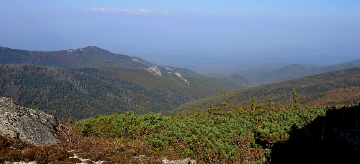
The Call of the Tiger Park has 56 mountain peaks over 1000 m high. Mount Cloudy aka Oblachnaya (1,860 m) is the highest point in the Primorsky Territory although it is not located on the main ridge Sikhote-Alin. Climbing this mountain is not an easy task, there are practically no equipped drive-ins nearby. Tourists climbing the mountain pass first the broad-leaved taiga belt, then the dense spruce-fir forest filled with the aroma of pinewood tar. Above, there is a scrubby forest of stone birch with funnily crooked white trunks. Even higher, on top of the mountain, there is a blossoming mountain tundra with a stunning carpet of flowering plants among which one can spot several species of rhododendrons.

The top of Mount Cloudy is a stone desert. Considerable altitude, strong winds and frosts do not allow any tree to grow here, which allows for unabstracted views from the top. On a clear day from the height to which even birds rarely fly, you can enjoy a stunning view of the Ussuri River, Mountains Snowy and Sister. The whole region is in full view spread in front of you in all its beauty, it stretches over tens of kilometres. At the top of Mount Cloudy, there is a stone tower - a shelter from the wind built by tourists. According to the tradition, everyone climbing this mountain must bring a stone for this tower. It’s interesting, if you count those stones in the tower, will see how many daredevils were able to conquer the height?
The age of these two mountains is about 250 million years. To continue a family tradition of naming, there is a kind of a relative of these mountains nearby, called Nephew Hill. At the foot of Mount Stone Brother in ancient times, there used to be a pagan idol temple. There is a belief that if you come to the mountain with a good heart and pure thoughts and ask it for something, your wish will certainly come true.
Snowy Mountain aka Snezhnaya (1,691m) is one of the five highest peaks of the Sikhote-Alin mountain system. It offers a beautiful panoramic view of the mountain ranges spreading in different directions and covered with mountain tundra interspersed with thickets of mountain cedar.
The main feature of this mountain is the source of the Ussuri river on its slopes. It is the most majestic river of the Primorsky Territory. The first 50 km of the river runs through the territory of the national park. The mesmerizing beauty of the river captivated the outstanding travellers Nikolay Przhevalsky and Vladimir Arsenyev. On the slopes of the mountain grow low cedars, low spruce trees and cedar shrubs. In summer, the emerald green ridges are covered with berries, you can enjoy excellent lingonberries and blueberries, mountain flowers delight the eye. Wild pink peonies are especially beautiful.
In sunny weather, the Sikhote-Alin mountains and the Przhevalsky mountains can be seen from the top of the Snowy Mountains. The top of the mountain is an even stony ground with almost no vegetation at the highest point. In summer, tourists set up their tent camps here. The climb to the top is quite difficult. The trail loops between huge boulders and powerful roots of centuries-old coniferous trees.
In winter, the slopes are completely covered with snow and the peak justifies its name – Snowy. The southern and eastern slopes of the mountain are avalanche-prone so you need to be careful when climbing in winter. Mountain Snowy is included in the list of 10 peaks that need to be conquered to get the nomination of a Primorsky leopard. Anyone can participate in these climbs regardless the citizenship.
The list of the mountains to be conquered should you wish to become a Primorsky leopard.
Cloudy 1,854m Snowy 1,682m Sister 1,671m Gora Otkrytaya 1.272m Gora Fasol’naya 1.314m Gora Gorelaya Sopka 1.471m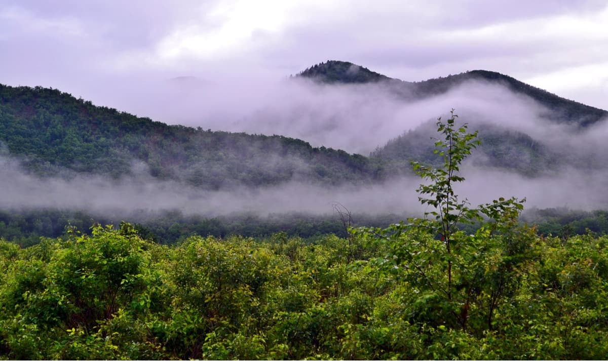
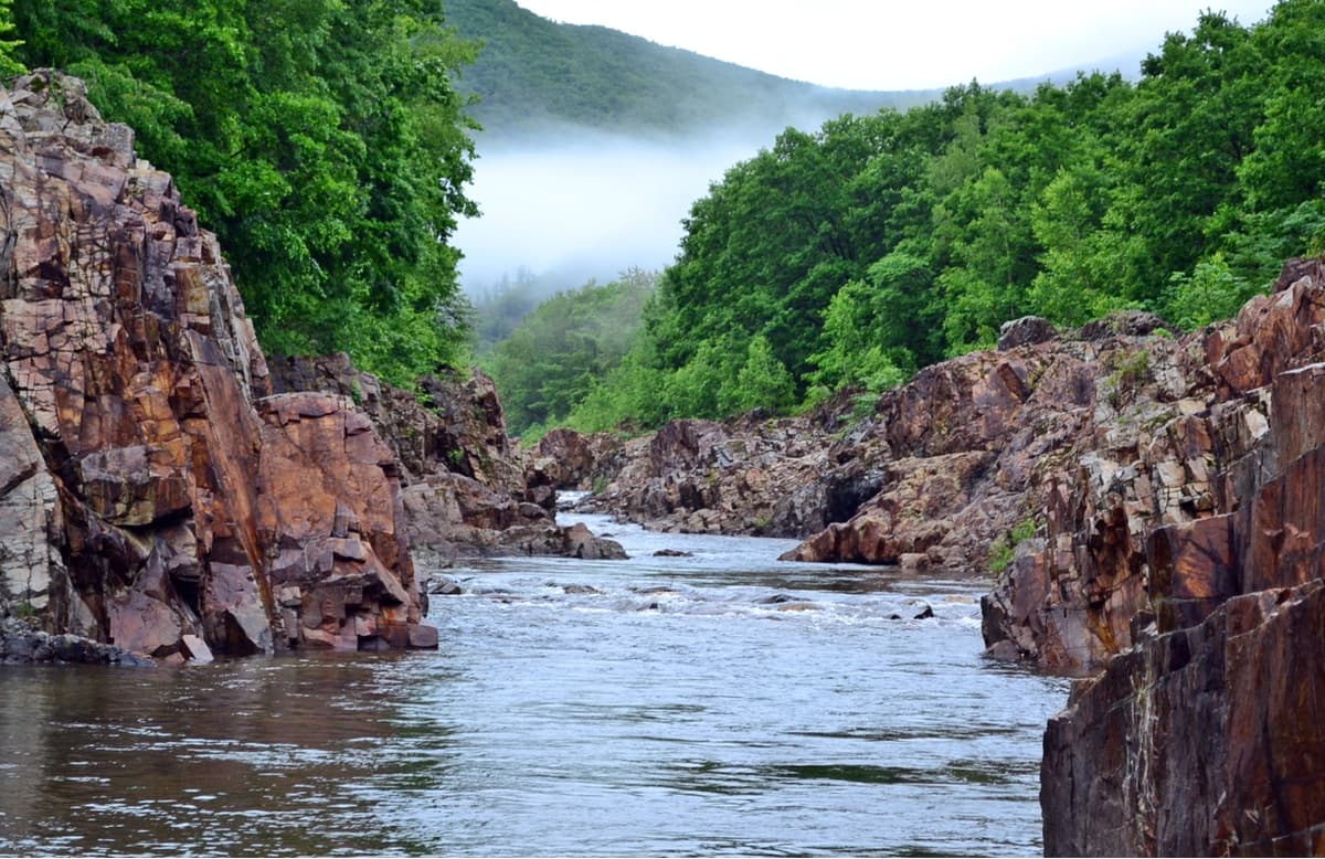
Mount Bald (1,560 m) fully justifies its name, its top is covered with smooth steep rockslides. Its top is well visible from the northern side. The mountain is surrounded by numerous tributaries of the Kievka River. At the foot of the mountain in a narrow stone gorge hides a cascade of magnificent mountain waterfalls, more than 20 falls of varying heights. Noisy streams of clear ice water roll down the mountain rocks and break into the stone plateau. These are the famous Benevsky waterfalls. At the very top of the mountain, there is a spring with crystal clear water which is heavenly tasty.
Climbing this unusual mountain is considered easy because you can drive up to a height of about 1200 meters, providing it is a 4-wheeler and it can cover the old forest road, and the remaining 400 meters are very walkable. You should drive to the village of Benevskoye along Vladivostok-Lazo highway. You can also reach the footpath by public transport. There is a bus route Vladivostok – Preobrazheniye from the bus station in Vladivostok. You need to get off a little before reaching the village of Benevskoye.
Climbing Mount Bald will allow admiring magnificently impressive views from the Lazovsky Pass and getting to know one of the highest peaks of the region.
In the Middle Ages, towns and villages of the Bohai state and the Golden Empire of Zhurzhen (the 7-10th centuries AD) were located in this area. There are 2 state natural monuments and objects of high aesthetic importance in the national park.
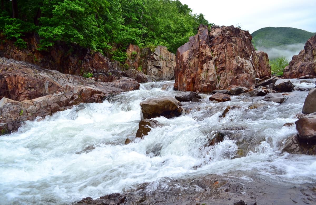
The Milogradovsky Waterfall often called Divny (Wondrous) is the largest waterfall of the region by the volume of falling water. The river water drops here from a 7-meter vertical ledge at up to 2-3 cubic meters per second! The show is nothing short of spectacular, you simply get mesmerized by the water. There is no lack of viewing platforms. There are no less than 7 waterfalls on the territory of the national park. Some of them are much higher than the main one but are inferior by the amount of falling water. Yet, each of the waterfalls is beautiful in its own way.
There are plenty of exciting journeys to do in the Park. The main routes include the ones called Sister and Stone Brother Mountains, Cloudy Mountain, Snowy Mountain, Milogradovka River.
Routes to the River Milogradovka pass by picturesque streams, the Blue and Pink Rapids and waterfalls. The main route to the Milogradovka River runs along the valley of the Solnechnaya Pad brook. The turn of the road is located between the village Old Kamenka and the village Sokolchi 200 m in front of the bridge over the brook. This old forest road rises to the watershed between the Black (Chernaya) and Milogradovka Rivers, which is the border of the national park. From here you can easily walk to the waterfall Divny, to the Blue and Pink (by the color of the rocks) Rapids, see a quaint Botanical Garden with centuries-old trees.
Route to Cloudy Mount. The hiking route is 11 km long. The estimated time is 10 hours. The best time to do it is May to September.
On top of Mount Cloudy (1,854 m) stands a peculiar tower, a shelter from the wind. According to a long tradition, every climber must bring a stone for this tower. The tower has a magnificent 360-degree panoramic view. The Sikhote Alin Range with its peaks Sister in the south and Snowy in the east are well visible. In the north, you can see the valley and the tributaries of the Izvilinka River.
Route to Mount Snowy is a combined trek for cars and pedestrians. The route length is 12 km from Upper Ussuriysk road. The estimated time is at least 4 hours. You can drive 11 km and then go on foot for 1 km. The season to visit is from May to September. The route is designed for people of different ages, but those trekkers should be able to withstand the altitude gain of almost 1 km. The main danger is to start descending from the mountain in the fog or in a cloud and do so in the northern or eastern direction, not the way how you ascended. Wild animals can also pose some problems.
This is the fifth highest mountain of the region (1,682 m) that crowns the main Sikhote-Alin Range. On its south-western slope, the Ussuri River starts, the largest river of Primorye, the right tributary of the Amur River. The Ussuri is the natural border between Russia and China. From the top of the mountain, there are fabulous views of the Ussuri Valley and the Sikhote Alin Range. On the southern slope, close by the road, the Klyuchevoy Stream starts its run from a specially equipped pipe. The road to Snowy goes along the crest of the ridge.
Route to Sister and Stone Brother Mountains is also meant for driving and hiking. The route length is 14 km by car from the highway Lazo to Olga and 7 km to The Dragon’s Teeth on foot. The estimated time of the route passage is at least 8 hours. The season is the same, from May to September.

The route is known first of all for its many stone idols, or pillars of bizarre shapes and different heights on the ridge on both sides of the Stone Brother Mountain. The most famous is the Dreamer, it has the shape of a man's head looking up to the sky. Other stone idols resemble a bird, a dragon or some other creature depending on the distance, the angle of observation and surely the imagination of the onlooker.
The route to Sister and Stone Brother Mountains runs from the south along the Medonosnaya Pad Creek. After the village of Lazo, go just ten kilometers along the federal Vladivostok-Olga highway to the sign "To the Dragon's Teeth", then the road turns left. In 4 kilometers, the road will enter the forest cool. Farther on, it winds and loops among trees along the valley and gradually rises upwards. It ends at the watershed of Mount Calendar – Lazarus at an altitude of about 820 m. There is a platform with a table, a fireplace, a woodshed and a toilet. About 5-7 tents can be accommodated on the site. Lack of water is a significant disadvantage of the site. Therefore, stock up on water beforehand.
Park Administration: Primorsky Krai, Lazovsky district, Lazo village, 56 Tsentralnaya str. The nearest town: Partizansk
You can get into the park by car through several entrances. From the south, you can drive into the territory from the road Nakhodka – Lazo – Olga; from the north, along the highway Chuguevka – Verkhnyaya Breevka – Arkhipovka – Yasnoe which has a car park at the entrance of the park. There is a daily bus from Vladivostok to Chuguevka, the nearest railway station is situated near the park's northern border in Novomikhaylovka village (the railway branch Sibirtsevo-Novomikhaylovka). The second railway station is in Sergeevka village, here trains go from Partizansk. It is about 70 km from Sergeevka to the administration of the national park.
You can fly to Vladivostok by plane, the travel time from Moscow is 7 hours 40 minutes or by train, the trip takes 5-6 days.
In Lazo, you can stay in a hotel or rent a room or a house from the locals. In Chuguevka, there is a Visitor Center of the park, where you can also stay. You can pitch a tent on the territory of the park itself.
Important Note
In order to enter the national park, you need to apply for a visit. You define the route, get an invoice for payment at Sberbank, and, based on the receipt, the park administration sends the permit to the park inspectors who will settle your visit at the entrance to the park.


The highest peak in "The Call of the Tiger" National Park is Gora Oblachnaya, at 1,860 m.
Notable peaks in "The Call of the Tiger" National Park include Gora Oblachnaya, Snezhnaya, Gora Sestra, Bastion I Zhuzha-park and Gora Gorelaya Sopka.


