Scan the QR code and open PeakVisor on your phone
On May 18, 2013, the Colorado Division of Parks and Wildlife opened its 41st state park to the public. Staunton State Park is located about 40 miles southwest of downtown Denver, just a couple of miles off U.S. Highway 285. Since then, this newest of all state parks in Colorado has become one of our favorite places to go hiking in the foothills of the Rocky Mountains. The park is situated partly in both Jefferson and Pike Counties and encompasses almost 4,000 acres. Its elevation varies from 8,100 feet to over 10,000 feet making it an attractive recreation option at all times of the year, although it can be quite hot during the summer months.
The park evolved initially from a 1,720-acre parcel of land, donated to the state in 1986 by Frances H. Staunton, to its current size as subsequent parcels of land were acquired. The original bequest stipulated that the Staunton Ranch, which was first settled in the early 20th century, eventually be developed into a state park. Elk Falls Ranch, on the west side of the park, was purchased in 1999. This acquisition added such landmarks as Lions Head, Chimney Rock and Elk Falls to the park. Also acquired in 1999 was the 1000-acre Davis Ranch located at the east side of the park. This included the present Davis Ponds accessible by trail and popular for fishing.

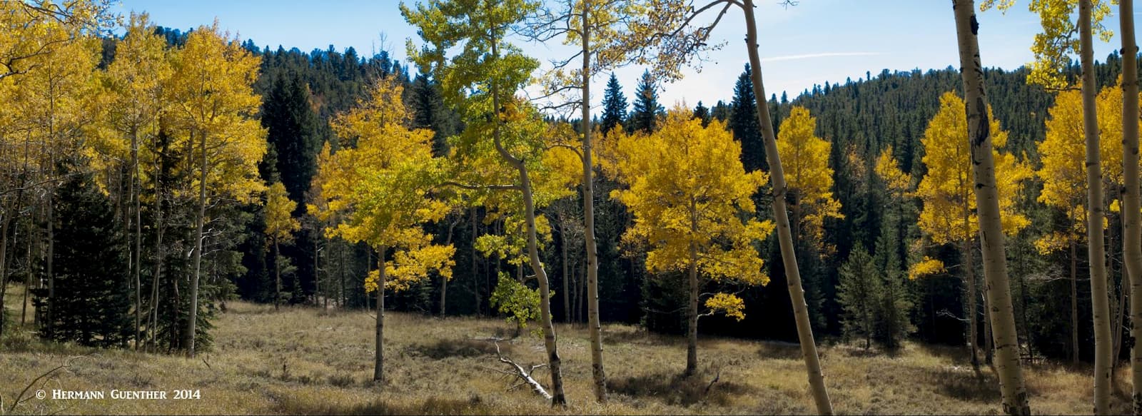
The terrain of Staunton State Park varies in character from grassy meadows at the lower elevations (8,100 feet) to soaring granite cliffs reaching to well over 10,000 feet. In between there are extensive areas of montane forests which cover the vast majority of the park, including Ponderosa Pine, Douglas Fir, Lodgepole Pine, Engelmann Spruce, Limber Pine and Aspens. The latter are especially dominant in the autumn when they change to their brilliant fall colors.

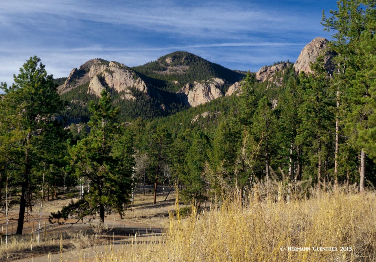
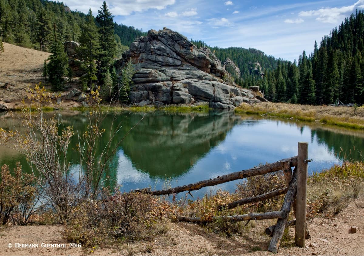
Part of what makes Staunton so interesting and beautiful is its geology. The park lies on a large formation known as the Pikes Peak Batholith which was formed as the earth’s crust was pushed up from its liquid core. It then intruded into Precambrian metamorphic rocks, subsequent to which uplift and erosion exposed the granite and eroded most of the Precambrian rock. This resulted in the spectacular granite cliffs and outcrops like Lions Head, Chimney Rock, Elk Creek Spires and Staunton Rocks.

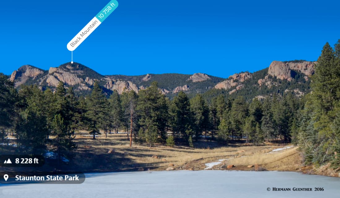
Interestingly, though the highest (and only) named mountain in the park, Lions Head, peaks out at an elevation of 9,446 feet, it is not the highest elevation within the park’s boundaries. The park includes some slopes of the much higher Black Mountain (elevation 10,756 feet), the summit of which is just outside of the park towards the north. Hence, the highest elevation in the park is approximately 10,300 feet.

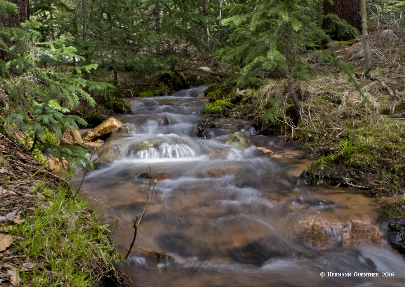
In addition to the two Davis Ponds, there is another pond, Elk Falls Pond, near the western end of the park; it lies at an elevation of 8,846 feet. And as the name implies, it is the source for the Elk Falls. There are also several creeks within the park that flow intermittently depending on the time of year. Fishing is permitted in all of these waters, but a Colorado fishing license is required. But some of these creeks are so small that I doubt that they would produce real quality trout fishing.
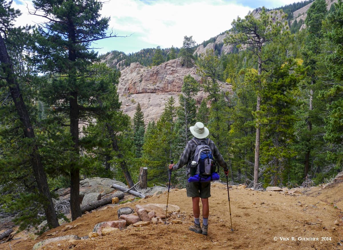
Staunton State Park offers a variety of recreational activities to pursue, suitable for all kinds of interests and visitors. Though we are concentrating mostly on hiking here, it is important to point out what other activities can be pursued here. There are a number of rock-climbing locations within the park, including Lions Head as well as several of the impressive cliffs, but seasonal closures must be expected to protect raptors. Some of the trails are open for mountain bikes and horseback riding, while others are for hikers only. There is also a campground in the park, but for tent camping only. You have to carry all your gear to your campsite – distances from the parking lot vary from 100 to 800 yards, so pack light! In the winter, when snow conditions are right, cross-country skiing and snow-shoeing are also possible. Pets are permitted, but must be on a leash at all times. An entrance fee is required of all visitors.

There are 17 hiking trails in Staunton State Park totaling about 30 miles. Some are very short and others quite long. With the parking lots concentrated at the southeastern end of the park, some hikes can get really long and may not be suitable for everyone. If you want to do some of the trails farther out from the main trailheads, you will have to hike on one or more other trails just to get to them. As a consequence, you can do some really long hikes depending on the combination of trails you choose. The longest hike my wife and I have done was 12 miles, but longer combinations are possible. Let’s look at some favorite hikes we have made.

Staunton Ranch Trail – This is the “main” trail in the park from which all the others diverge. It has a one-way length of 3.1 miles and is generally fairly level, with an elevation gain of 940 feet, an average gradient of less than 6%. While you get to see many of the fine cliffs from this trail, it is otherwise not very exciting. It sees more foot traffic (plus mountain bikers) than many of the others due to its central location. By necessity, most of the hikes described herein involve hiking parts or all of this trail, in many cases on both the outbound as well as return legs.

Mason Creek Trail – This is the longest trail in the park at 4.5 miles one way. So you have to figure that your total hike will be nine miles unless you return by a different route, which I highly recommend. The trail is mostly in the forest following Mason Creek so that it does not offer any great views. However, near the upper end is a new trail, the Bear Paw Trail, which diverts from Mason for 2.3 miles before rejoining it a mile further up. That side trail leads to three new overlooks which should be very interesting. I have not done that one as of this writing but am looking forward to that.
Border Line Trail – As the name implies, this 2.5-mile trail follows partly along the northern park boundary. It can be regarded as an extension of the Mason Creek Trail, with which it connects at the Old Mill Site – an early 20th century saw mill, relics of which are still to be seen here. This is a beautiful trail that also serves a short spur to the Staunton Rocks overlook. At the other end, this trail intersects the Staunton Ranch Trail which you can take back to the trailhead. Or you can opt to go miles further if you are up to it.
Scout Line Trail – This is one of my favorite trails in the park, partly because it is for hikers only. No matter how you hike this 1.5-mile trail, you will somehow have to combine it with the Staunton Ranch Trail, with which it has a junction about two miles from the main trailhead. From that point, this hike can be turned into a partial loop. If you choose to go clockwise, you will have a steep climb up several switchbacks to a ridge from which you can connect back to the upper end of the Staunton Ranch Trail via a short segment of the Marmot Passage Trail (see below). Doing the loop in reverse is less strenuous. From the top of the switchbacks you can get a great view of 14,117-foot Pikes Peak fifty miles to the south.

Marmot Passage and Bugling Elk Trails – These two trails can and should be combined into a 3.1-mile loop that will take you over some beautiful terrain and eventually to Elk Falls Pond, at the west end of which is a log cabin. The pond is a lovely sight and I prefer approaching it in the clockwise direction such that your first glimpse of the pond is from high above it. You can access this loop from either the Staunton Ranch Trail or the Scout Line Trail. Just be aware that doing this loop is in addition to all the miles you have to hike just to get to it. You are looking at an overall hike of at least 10 miles, but it is oh so worth it!
Lion’s Back Trail and Chimney Rock Trail – If you still haven’t had enough, you can do this 2.1-mile loop which starts at the Elk Falls Pond (see above). This loop, in turn, will take you to two junctions each of which takes you a third of a mile further to two good spots. One is the Elk Falls Overlook. Don’t get too excited about this one – we went there once and you can indeed see the falls from there. But they are very far away. It is better to take the other spur trail which takes you directly to the falls in about a third of a mile. This is preferable, but the downside is that you lose a lot of elevation to get there, which you have to regain on the way back. But I recommend it.

Needless to say, there are other combination hikes you can do depending on how much time and energy you have. One nice combination we have done is to go up the Staunton Ranch Trail, then go left at the scout Line Trail to its end at Marmot Passage which you take one-half mile to its intersection with the Staunton Ranch Trail. Then you continue on the Border Line Trail to the Old Mill Site, where you can then take the Old Mill Trail back down to the Staunton Ranch Trail which you follow back to your starting point. This hike is only nine miles long and gives you some of the best the park has to offer without overdoing it. This was our first hike shortly after the opening of the park. The variety of views, whether up close or distant, will ensure that you will never be bored hiking in this wonderful state park.

We already know that Staunton State Park is easily explored from most of the greater Denver area, with the southwestern suburbs of the city naturally being the handiest in terms of distance to the park. Denver and its suburbs offer all the amenities a visitor to the area can hope for. But in addition to the metropolis, there are some little towns nearby that deserve some attention as well. Perhaps not so much in terms of what they offer in the way of accommodations or restaurants. It is the attractions they also offer the visitor – a number of nice foothills locales where you can find other fine hiking venues as well as a little historic charm to entertain you.
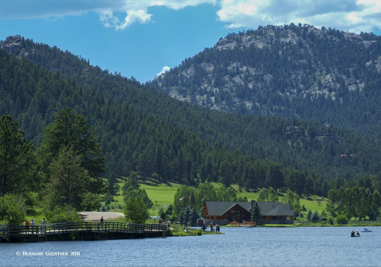
These two communities with populations of 9,200 and 8,200 respectively (elevations of 7,220 and 8,277 respectively) are fundamentally “bedroom” communities for people who want to live in the mountains yet need to be close enough to the city for commuting to work or for shopping and entertainment. Their semi-forested environment is conducive to clean air and somewhat cooler summer temperatures. They also get more snow in the winter. While Evergreen is closer to Interstate Highway 70 (I-70), Conifer is right on U.S. 285. Their respective town centers are only nine miles apart via County Road 73. Both towns are handy to other fine hiking areas, especially several Jefferson County Open Space parks with miles of trails. Living with wildlife is part of everyday life in these communities. Evergreen is also blessed with a beautiful lake nestled in a grand mountain setting and offering a variety of recreational opportunities.