Scan the QR code and open PeakVisor on your phone
Shebenik-Jabllanice National Park is Albania’s youngest and one of the biggest national parks. It is one of the true Albanian backcountries, lying on the border with North Macedonia and featuring lush forests and rocky mountain peaks. There are 28 named mountains in Shebenik-Jabllanice National Park. The highest and most prominent mountain is Maja e Shebenikut (2,265 m/ 7,413 ft).
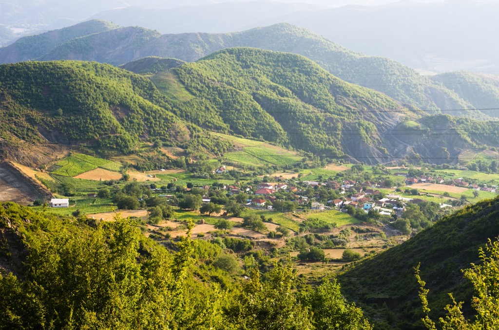
Shebenik - Jabllanice National Park is located in the east of the country of Albania. It was created in 2008. The park is a total of 33,927 ha (83,835 ar) in area, and the main part is made of forests and pasturelands with agricultural land. There are also rocky and barren peaks that comprise part of the park's overall size.
Elevations in the park vary from 300 m (984 ft) to over 2,200 m (7,217 ft) above the Adriatic, at the peak of Shebenik and Jabllanica or Maja e Shebenikut (2,265 m/ 7,413 ft)
The territory of the park includes six municipalities and twelve villages, with a population of 15,000 people. The municipalities are Stebleve, Qender, Qukes, Hotolisht, Lunik, and Rrajce, in the Elbasan County, and villages such as Llange, Kosharisht, Zgosht, Letem, Qarrishte, Skroske, Gizavesh, Dorez, Rrajce Skenderbej, and Rrajce Bardhaj.
The park’s two mountain ranges include Shebenik Mountain, the park’s namesake, and Jabllanica. The park is managed by the Ministry of Environment in the towns of Librazhd and Prrenjas. They have actively protected the park’s natural landscapes and wildlife, all while maintaining it as one of the biggest parks in Albania.
The borers of the park included in the north the Librazhd-Steblevë highway, and south are Rrajce, Qukës, and Hotolisht municipalities. To the east is the border with North Macedonia, and to the west is the Bustrica River.
One notable reason for this relative inaccessibility and lack of awareness of the park is that residents could enter during the Communist era in Albania. While access has recently become accepted, the main issue remains the lack of marketing surrounding one of Albania’s most famous natural treasures.
The park offers some of the most scenic surroundings and landscapes in the Eastern part of Albania. It contains a total of fourteen large glacier-formed lakes, with the lakes located between 1,500 and 1,900 m (4,921 ft and 6,233 ft).
Roughly 21,294 ha (52,618 ar) of the park's territory is protected by UNESCO as a World Heritage Site and is part of the Primeval beech forests of the Carpathians and other regions of Europe.
The stunning mountains of Shebenik and Jablanica, along with the region of Rajca have been recently recognized as Important Plant Areas and part of the European Green Belt due to their essential plant and animal species like salamanders, lynx, birds, and bears.
Ecology plays a significant role in the region. Some more noteworthy examples of significant flora include beech, fir, black pine, oak, and spruce trees. Also important to note is that there is variety when it comes to herbaceous vegetation, such as flowerbeds and meadows.
Special values have hydrography, with rivers, streams, artificial lakes, springs, and karst water basins. Shebenik - Jabllanicë National Park, tourists have the opportunity to enjoy the beautiful karst lakes, while other attractions include mountain peaks, rural villages, and many others.
Shebenik-Jabllanice National Park, just like its name says, hosts both Shebenik and Jabllanice mountain ranges.
Mt. Shebenik lies near the city of Librazhd, it features several peaks that reach over 2,000 m (6,561 ft), and its highest point is Mt. Maja e Shebenik. The peak is located in the northwest of Shebenik rage. Around the mountain peaks, there are numerous mountain lakes, and Shebenik range lies west of Jabllanica and northwest of Ohrid.
Jablanica is a mountain in Albania and North Macedonia, which lies along the border between the two countries. The long mountain ridge is higher than 2,000 m (6,561 ft) and about 50 km (31 mi) long, while the highest point is located in its center.
Both North Macedonia and Albania share half of the mountain, which contains many large lakes, in addition to Mount Shebenik, which is near the border with North Macedonia. Jabllanica is only a two-hour drive from both the main cities of Albania and Macedonia.
The park has a diverse geological history. It encompasses most of the connected mountain massifs of Shebenik and Jabllanicë, which housed the deposition of many different sediment layers from geological time periods. The area shows a record that spans all three major regions: Mesozoic, Jurassic, and Triassic.
The mountains are formed of ultramafic rocks and metamorphic rocks, but calcareous rocks are the most common types of rock seen here.
The area is dominated by a mountain group formed in ancient times and which is made up primarily of carbon and karst. The solid rocks date back millions of years and permit little vegetation to grow through them.
The mountains took the shape of their present-day looks because of the huge glaciers that covered much of Europe during the last Ice Age. Glacial action is found in quite a lot of places throughout the park.
It is visible in the form of U-shaped valleys, cirques, and several bodies of water. The glacial action has been evident for more than 10,000 years now since the end of the last ice age. Small cirque glaciers are common in these mountains even today because they sit between mountain peaks and depressions on the side of mountains.
The bedrock that the park lies on extends above the forest belt. It dates back to when the mountain chain formed, a predominantly carbon-based layer, and is unique to the area. You can see from its color that this rock layer has only ever seen shallow groundwater.
The two rivers that feed the park flow on either side of Shebenik-Jabllanice National Park are Qarrishta and Bushtrica. There are other smaller water sources, but only Qarishte and Bushrzhicha are 22 km (13 mi) long. They join at the exit of the park and then flow into the Adriatic Sea.
When it comes to hydrology, that is not all since there are over 14 small glacial lakes found in the park, which are located at an altitude of 1,500 to over 1,900 m (4,921 ft over 6,233 ft). Most of the parks fall into the Mediterranean climate category. The park includes these notable peaks:
The variety of vegetation and remote locations encourage wildlife to flourish in Southern Europe and Albania, largely because they aren't disturbed by humans. In fact, this region has a number of endangered types of animals that people might be surprised to see. Shebenik-Jabllanice National Park is one of those closed-off regions.
In total, there are three types of natural habitats, which include forests, shrublands, and grasslands. Grasslands are commonly found at very high altitudes, while forests are primarily found below the tree line due to the forested area being smaller and spread out.
One of the biggest attractions in Albania's Shebenik-Jabllanicë National Park is its diverse flora due to its geographic features. The park is home to 32% of the flora found in Albania. They start with plants like oaks, black pines, beeches, and white firs and progress on to alpine pastures.
A lot of plants are endangered in the park. Therefore, their protection is necessary. Some of these plants include yew (Taxus baccata), sturgeon (Tilia platyphyllos), and mountain maple (Acer platanoides).
Since flora is so rich with species, it comes as no surprise that there is a variety of fauna too. Some are endangered, such as brown bears, roe deer, and others. Other species encountered here include wild boar, griffon, and many types of sparrows. The park hosts the Balkan lynx, a subspecies of the Eurasian lynx.
You'll also find many types of reptiles in this diverse wilderness. The hunting moratorium has brought more wild animals into the park. There are so many species of birds in the mountains they can create a beautiful soundscape. Some species include wild turkey, falcon, partridge, and eagle. The beautiful sounds of these birds fill the air and give you peace of mind when nature is working its magic.
The Rrajca forest is of special interest and is listed as a UNESCO World Heritage site. This forest is found above the tree line as they, too, are bordered by high mountains on all sides. With its diverse elevations, the park falls within the Dinaric Mountains mixed forests terrestrial ecoregion of the Palearctic temperate broadleaf and mixed forests.
The Dinaric Mountains mixed forests are a temperate coniferous forest in the western Balkans that is home to many unique species of plants and animals. Human activities have significantly impacted these forests over the past century. The most significant impact has been deforestation caused by agriculture practices used since the early twentieth century.
The forests have a variety of trees, shrubs, and herbs with an abundance of life. They support the livelihoods of many people who live in the area and provide habitat for many animals as well.
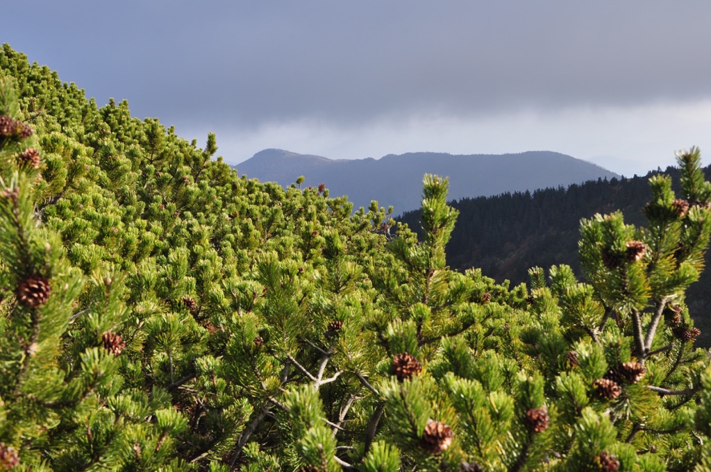
Mixed forests can be found all over Europe, from Spain to Russia, but they are most common in mountainous regions like the Dinaric and Albanian Alps. There is usually a mix between conifers (mainly pines) and broadleaf trees like oaks, beeches, maples, and birches.
There is a variety of rare plants, mammals, and fungi that live throughout the forests and in the park, which makes it an ideal place to visit. Beech, fir, pines, oak species, as well as rarer varieties like purple willow, Norway maple, and silver birch, are all part of the flora. Some additionally include a variety, such as silver fir and Bosnian pine.
There are several natural monuments in Shebenik-Jablanica National Park, which include: the Qarishta birch forest, Kosharishti cave, the source of Well, the birch tree of Rajce, and many more.
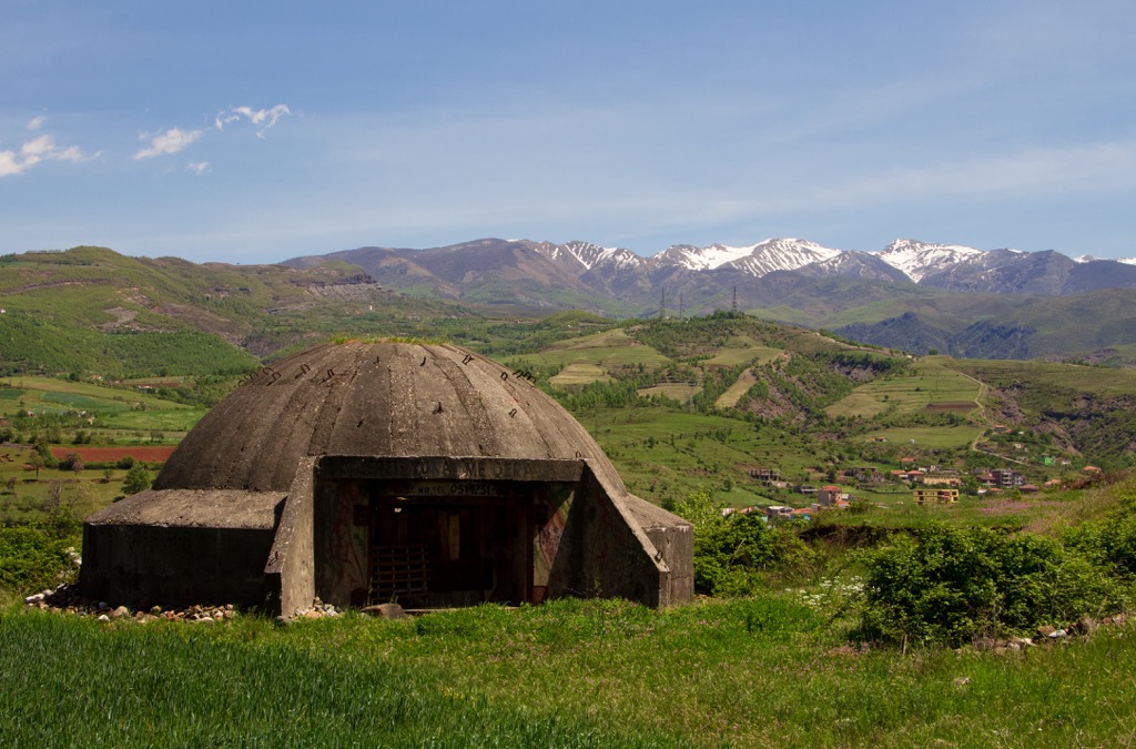
There are also many environmental problems in Shebenik-Jablanica National Park, which is a natural treasure. The high ecological diversity at the site has made it difficult for scientists to study it comprehensively. Some species are at risks, such as birch and thistle walnuts, for example. The wild fauna has suffered a great deal of damage, with the lynx, wild goat, roe deer, wild turkey, and even the mountain trout on the brink of extinction.
Humans have always settled here only during summer to provide for their livestock a place to roam free. Still, when people settled in these villages permanently, they also started building their homes and religious objects, leaving traces of their life to us today. This is why we have numerous historical monuments inside Shebenik-Jabllanice National Park.
Scanderbeg's staircase and table are wonderful historical sites in Shebenik-Jabllanice National Park. There are also several cultural features, such as natural caves, including Glaciers, Christ's, and Eremite caves, once inhabited by humans.
Qukesi is a charming village in the northern part of the park with incredible views that requires regular visits to see just how picturesque it can be. Stone construction and manufacturing of stone goods are still done by locals today, together with the performance of traditional dances.
Kosharisht is a small village located inside Shebenik-Jabllanice National Park, and the cave of this community has a history dating back to the eleventh century. This cave hosts a church or Koshorishti Church, which has beautiful frescoes inside.
Although the Ethnographic Museum in Librazhd endured significant damage, its cultural history and knowledge is an important local repository that remains intact.
Tourism in this area is still developing, but many visitors are coming here, and tourists enjoy it. The park has a lot of cultural heritage and historical value. Many monuments are open to visitors from all around the world. An example is the village of Llange, with characteristic stone houses arranged three stories high that were built using perennial construction methods.
This community functions primarily through its traditional cultural practices, which are the "heart" of this area. A number of traditional holidays or festivals help to define the character and identity of the people who live here. Many community members participate in their local festivals, which means it has good reach, and guests are invited to join as well.
The festivals in this area include Dorez, Shëngjergji, Qarrishta, Rrajce, Lunik, and more. Traditional folk costumes in some villages, as well as folk songs and dances, are shown during these festivals.
You can see them throughout the year, but 21st May is celebrated as the day this area was declared a National Park. Today, locals gather in Fushë Studë to celebrate this day. Locals prepare and sell traditional food, medicinal plants, and honey. They also perform local dances and songs that are popular in the area.
The economy, social life, and natural heritage of the communities in national parks depend on agricultural activities and products. It's challenging to find arable land for new farming activities, which is why one-third of this beautiful national park is under family ownership. It features fertile farmlands, orchards and vineyards, and pastures. Cattle are the primary breed of livestock, followed by goats and sheep.
Shebenik-Jabllanice National Park is managed by the Administration of Areas of Elbasan District, which is subordinate to AKZM. Through the policies and implementation of the law on Protected Areas, they perform the role of promoting nature conservation.
This administration works very hard to promote ecotourism, enlisting numerous specialists' help. They encourage tourism mountain so locals and foreign tourists can enjoy their beautiful countryside.
Next up are our favorite hikes in Shebenik-Jabllanice National Park:
Many people in the area are astounded at the striking sights this national park offers. This hike takes you to the highest peak of Shebenik-Jabllanice National Park. It's definitely a hike worth doing with picturesque views, and it is a two-day camping trip.
From the mountain village of Dragostunjë, this hike takes you through the high valley of Shebenik. The trail is only marked in the upper part, but finding your way is no problem, at least in good weather.
There are many different paths to follow, and there are lots of great spots to stop and take in the view, which includes seeing lakes on this trail. There are usually no other hikers, even in high season.
Your hike will start at the Fushë Studë Lake, a short distance from where you park. Highlights of this tour include the Traditional houses at Llangë Village, Lake Fushê Studë and Dragan Lake, and Maja e Katrafilit.
Hiking the two-way trip from Barrake to Maja e Katrafilit is an experience in itself. The hike passes the glacial Dragan Lake and offers picturesque alpine pastures.
From the summit of Faqet e Lemume, one can enjoy the park's beauty with its high forests and alpine pastures. Furthermore, North Macedonia is just visible on the horizon.
Your hike starts in Zgosht, where you park your car. This is a moderate hike with 11 km (6.8 mi) and 1,000 m (3,280 ft) of elevation gain. It will take about 5 to 6 hours to get there, and the cave itself is vast and cold.
That is, even if the outside temperature might be pretty warm during the summer. After passing through a beautiful forest, you will finally get to the cave or Shpella e Akullit and trek back down in about 4 hours.
These are the most significant cities and nearest towns to Shebenik-Jabllanice National Park:
Elbasan has a population of about 141,000 people, and it is one of the most important economic centers in Albania. The city has a long history dating back to antiquity.
Elbasan was founded by Thracians and later became part of Illyria. In 1478, Elbasan became part of the Ottoman Empire and remained so until 1912, when Italy occupied it during World War I.
Elbasan has always been at the crossroads between different cultures and civilizations due to its location on a major trade route through central Europe during ancient times. This makes Elbasan home to many monuments that stand out, such as Saint Prokopius’s church which dates back to the sixteenth century.
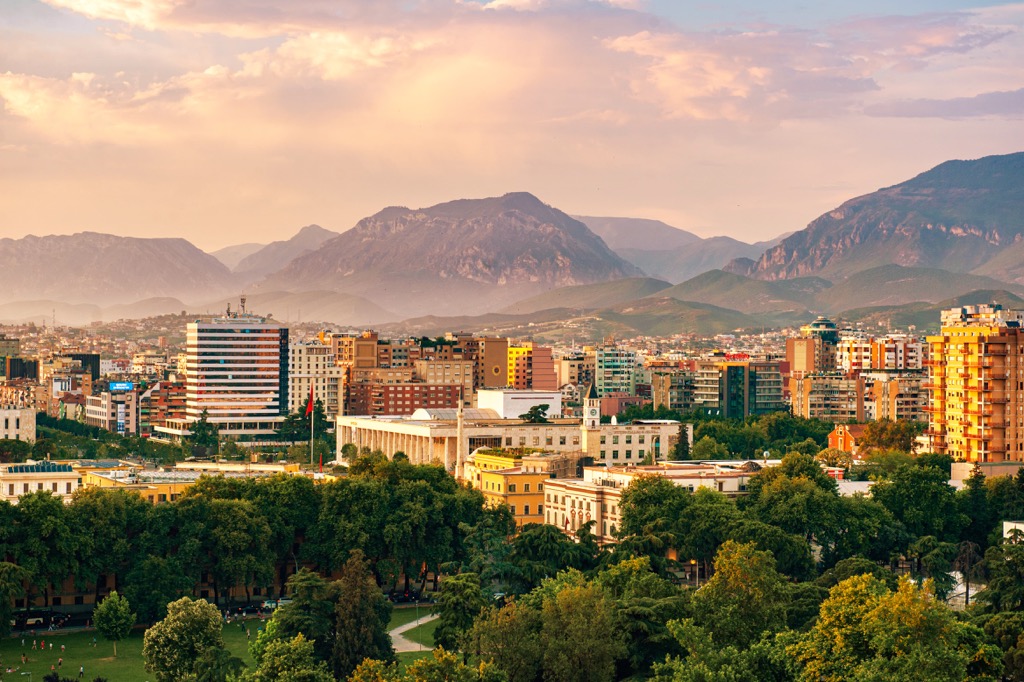
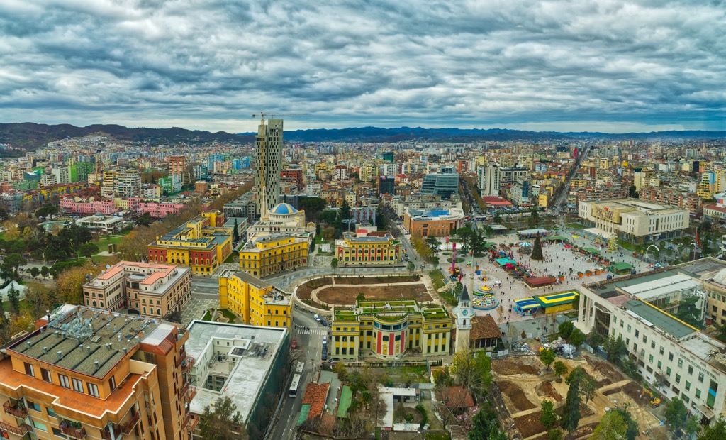
Tirana, the capital of Albania, is a city of about 500,000 people. It is the largest city in the country, and it has been an important trade center since antiquity. Tirana is not only a place of historical importance to Albania but also a place where you can find many different cultures.
Tirana has seen many rulers, from Turkish to Italian, influence throughout its long history. It is an important economic and transportation center for Albania.
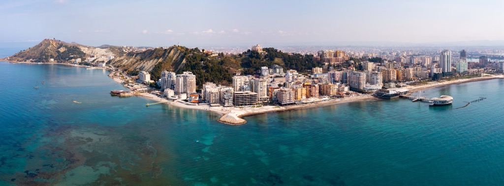
Durres is the second largest city in Albania and the capital of the Durres District. It is located on the Adriatic Sea. It has a long history dating back to antiquity. The city was founded by Greek colonists from Corinth and Corfu in 639 BC.
It was rebuilt by Corinthian settlers who called it "Dyrrachium." The Romans made Dyrrachium their most important port on the Adriatic Sea. Durres has been inhabited for more than 2,500 years. In addition to its rich history, Durres is also known for its natural beauty with a number of beaches and parks that are popular among tourists from all over Europe.