Scan the QR code and open PeakVisor on your phone
Sai Kung East Country Park is a showcase of pristine beaches, rugged peaks and unusual geology in the backyard of Hong Kong. Among the 35 named hills in the park, the highest and the most prominent one is Sharp Peak.
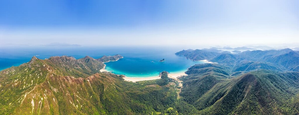
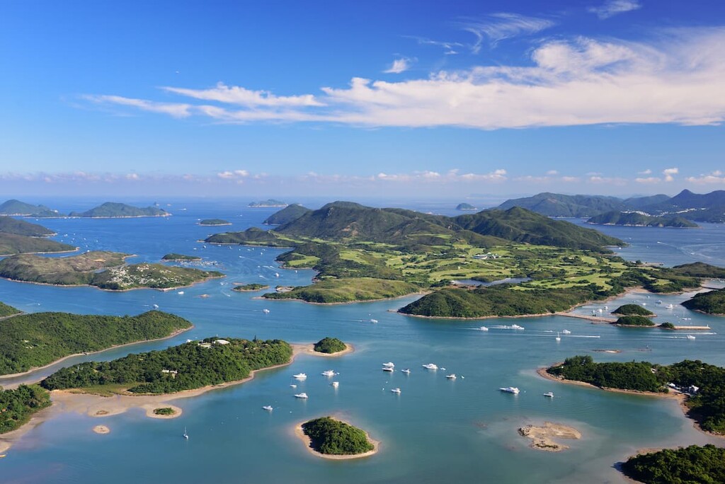
Sai Kung East Country Park encompasses 4,494 hectares (11,105 acres) of land at the easternmost part of the Hong Kong Special Administrative Region of China, borderingSai Kung West Country Park to the west and surrounded by the South China Sea on other sides.
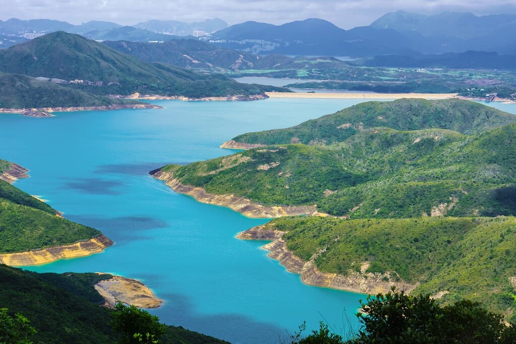
The long and sinuous coastline has produced the most number of coves and bays among all the country parks in the city. In the south of the park, ragged green hills give way to the mirror-smooth water of High Island Reservoir, the biggest reservoir in Hong Kong.
The reservoir used to be the Kwun Mun Channel between Sai Kung Peninsula and High Island. It formed after the channel was enclosed by dams that connect the eastern and western sides of the island to the peninsula.
High Island is no longer an island after becoming a part of both Sai Kung Peninsula and Sai Kung East Country Park. Off the east of High Island is Po Pin Chau, a sea stack that used to be part of High Island but was later cut off by erosion.
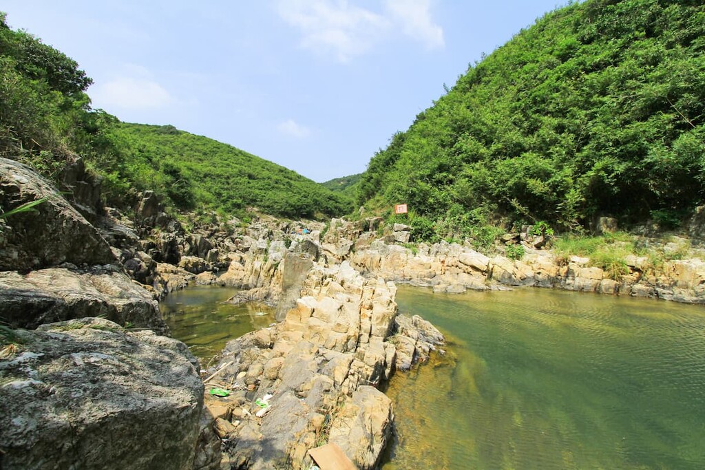
In the interior, Sheung Luk Stream threads its way among the hills until it empties into the sea at Sai Wan. The stream is famous for its plunge pools and waterfall. In Pak Tam Chung on the western border, the Orange River flows toward the bay of Tsam Chuk Wan through beautiful mangrove swamps.
In 2012, the submerged remnants of an ancient supervolcano were discovered near Sai Kung. As one of only fifty or so supervolcanoes ever found in the world, it was named the High Island Supervolcano since the top edge of its 18-kilometer (11-mile) caldera lies on High Island and extends all the way through Kowloon and Hong Kong Island.
The lava and ash produced by a massive explosion some 140 million years ago was responsible for the formation of most of Hong Kong and some of its most dramatic landforms.
Sai Kung East Country Park is an important part of the Hong Kong UNESCO Global Geopark because of its distinctive geological formations developed over volcanic rocks. The centerpiece of the geopark is the hexagonal rock columns in the country park, especially the ones on High Island.
The High Island Formation is made up of crystal-bearing fine ash vitric tuffs that clearly display columnar jointing as a result of rapidly hardening lava flows. Since the material was uniform, the cooling led to even shrinking and cracking into a hexagonal shape, which is the most efficient geometrical pattern of stacking. The hexagonal columns extend to more than 80 m (260 ft) in depth, reaching as much as 400 m (1300 ft) in places, and 1-2 m (3.3-6.6 ft) in diameter.
The most prominent geological feature, Sharp Peak, is composed of pyroclastic rocks that are severely weathered at the top. It has been gradually isolated as the surrounding fine ash vitric tuffs of the High Island Formation eroded away over time.
Additionally, while deposition by waves has created the many beaches in the country park, the coastline is also riddled with sea caves and arches left behind by erosion.
Major peaks in the park include Sharp Peak, Pai Ngak Shan, Tai Cham Koi, Tai Mun Shan, and Sai Wan Shan.
The soil in the country park is largely acidic and poor in nutrients, as well as high in salinity near the coast. The hillsides are covered with shrubby and grassy vegetation well adapted to the harsh conditions.
The most abundant shrubs include rose myrtle (Rhodomyrtus tomentosa), common melastoma (Melastoma candidum), and dwarf mountain pine (Baeckea frutescens). Among the most common grassland and heathland plants are hardy duck-beak grass (Ischaemum aristatum glaucum), mini reed (Arundinella nepalensis) and linear forked fern (Dicranopteris linearis).
Some trees that are tolerant of the environment can be found in the lowlands, such as the paper bark tree (Melaleuca quinquenervia), an exotic species introduced from Australia. The screw pine (Pandanus tectorius), with its pineapple-like fruit, is widely distributed along the coast, which also harbors salt-tolerant flora species like nodding swamp orchid (Geodorum densiflorum).
There are mangroves and mudflats in Pak Tam Chung and Chek Kang where freshwater meets saltwater, providing habitats for creatures like mudskippers and fiddler crabs.
Common birds in the park include white-throated kingfisher, Chinese bulbul, great coucal and magpie. In particular, Chek Kang is a hotspot for birds while Pak Tam Chung is a sanctuary for a hundred species of butterflies, including larger ones like the Chinese peacock and the spangle.
The Burmese python, the second largest snake in the world, is among the top predators in the country park. Feral cattle are a usual sight, but other mammals such as masked palm civet, Chinese leopard cat, small Asian porcupine and Chinese pangolin are mostly nocturnal.
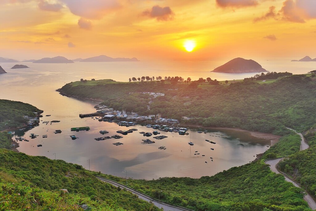
There are many historic villages in the region in and around Sai Kung East Country Park, the oldest of which date back to more than 300 years ago. Outside the villages, quite a few people used to live on boats. The people made a living from fishing and making lime from an ample supply of coral skeletons in the coastal waters.
Some villages were submerged to make way for the High Island Reservoir and some have been abandoned and some have been converted to other uses. For the few villages that are still inhabited, the current population is just a fraction of what it used to be, but some traditions remain strong.
Sheung Yiu, an old village built by the Hakka people in Pak Tam Chung, has been converted into a folk museum with rebuilt houses, a watchtower, a drying terrace and a lime kiln. Close by is the disused Our Lady of the Seven Sorrows Chapel, which was built in 1900.
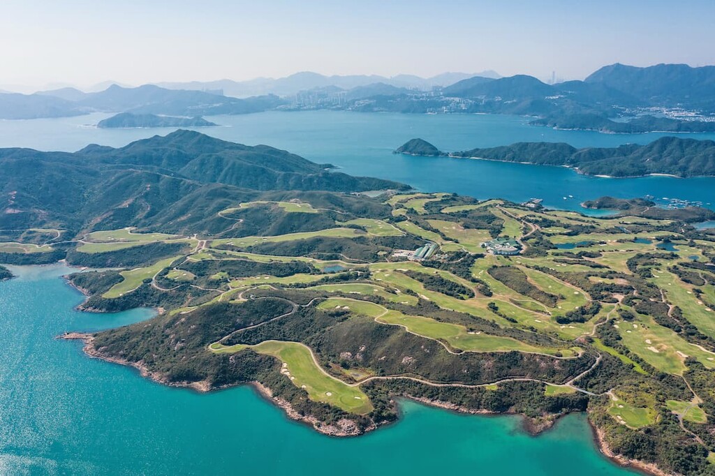
High Island has a rich and living human history on top of its impressive geological heritage. Being on higher ground than other islands (thus the English name of “High Island”), it was used as an important base for maritime defense for many years starting the 1500s.
The Tin Tau Temple dedicated to the goddess of the sea was built by the early eighteenth century and it has been renovated a few times since its initial construction. This well-tended temple hosts the Tin Hau Festival every year with pompous celebrations and parades (held biennially) on both land and sea.
Even though the villagers on High Island have always been devout followers of the goddess of the sea, Tin Hau, they warmly received foreign missionaries who first arrived in the 1840s. Catholic churches were built over time though they are now abandoned and dilapidated.
High Island once housed a detention center near the West Dam which served as a refugee camp for Vietnamese boat people from 1989 to 1998. It was closed down and converted into a water sports center and an astropark featuring Chinese and western astronomical instruments.
To this day, some villagers in the country park still live off the sea by fishing or farming seafood, while others have turned to visitors by running businesses like restaurants and vacation rentals.
The park offers nature at its best with rugged peaks, refreshing rock pools and a wild coastline. There are a few campsites, vacation rentals and a hostel for those who want to explore the park in depth.
Despite the hill’s moderate height of 468 m (1,535 ft), climbing up and down the Sharp Peak is anything but moderate, and should only be undertaken by very fit and experienced hikers. Aptly named Sharp Peak for its stark, jagged profile, this landmark in the park presents one of the most challenging hiking experiences in Hong Kong, to be matched by equally unforgettable views of the beaches of Tai Long Wan and the vast South China Sea beyond.
The trails on Sharp Peak are not only steep and exposed, but also littered with loose gravel, making it necessary to climb using your hands on occasion. Hikers usually tackle the way up from the southern ridge via Tai Long Au and Nam She Au, going down the same way or on the eastern ridge to the beaches of Tai Long Wan. For the most intrepid hikers, it is possible to go up the sheer northern ridge via Nam She Wan.
Hikers to Sharp Peak usually pass through Chek Keng, a shallow inlet with mangroves, a derelict hamlet and grasslands popular with campers. A destination in itself, Chek Keng is mostly flat and easy to walk. There is a hostel and a pier with ferry service between Wong Shek in Sai Kung and Ma Liu Shui in Tai Po with a few stops along the way.
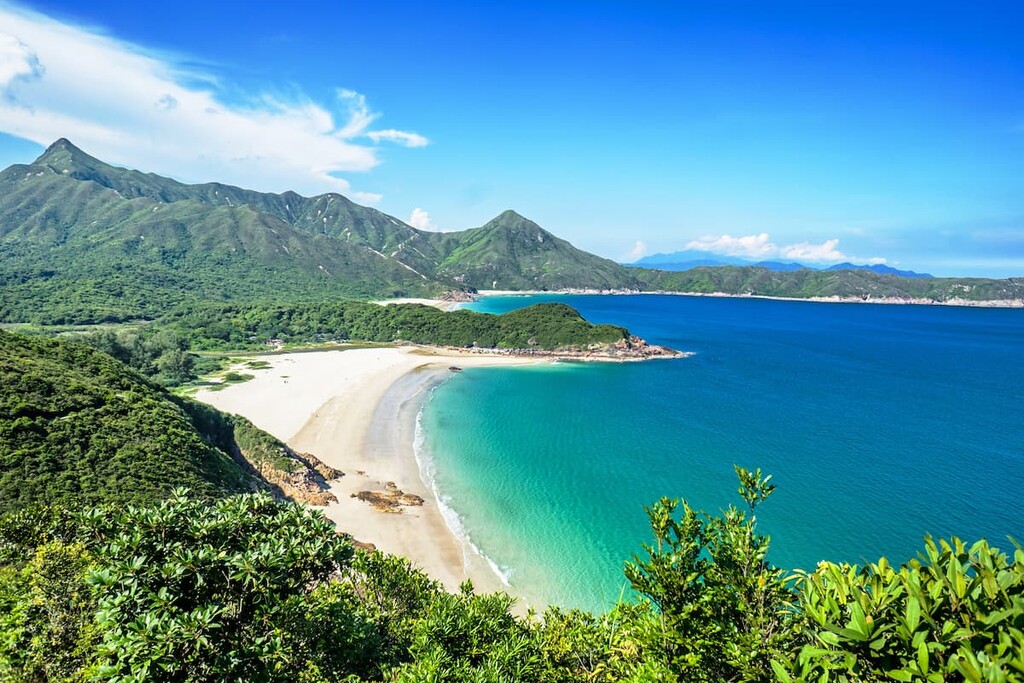
Powdery white sand beaches set against rugged green hills are iconic to Sai Kung East Country Park. Tai Long Wan, a 3-km (1.9-mi) bay of the South China Sea, is home to four of the city’s finest beaches—Tung Wan, Tai Wan, Ham Tin Wan and Sai Wan, which are separated by capes.
The name of “Tai Long Wan”, meaning “big wave bay”, comes from the unrestrained waves with powerful rip currents. The waters are more suitable for surfing than swimming. Cut off by rough terrain on the easternmost reaches of Hong Kong, the beaches have a secluded feel and are usually not crowded despite their stellar reputation.
The beaches are most accessible from Sai Wan Pavilion in the south. Hikers coming off the eastern ridge of Sharp Peak will arrive at the beaches from the north, and you can have the best of both by hiking from summit to sea on the same day, though you may also camp on Sai Wan.

To the south of Tai Long Wan and close to the East Dam of High Island Reservoir is the beach of Long Ke, widely considered to be the most beautiful in the territory. The famous hexagonal rock columns can be seen from the beach, which is sheltered by long promontories but the waves can still be strong. The beach can be accessed from Sai Wan Pavilion or the East Dam.
Camping is allowed on the beaches, but there are no facilities. So, campers must be prepared to be self-sufficient.
High Island plays a larger-than-life role in geology and has fascinating human history. The best places to see the hexagonal rock columns are in the east, on the East Dam or on Fa Shan. The East Dam is also popular for star-gazing since it is relatively free from light pollution, while the West Dam houses the Chong Hing Water Sports Centre with good facilities for both water sports and land-based activities.
It took nearly a decade to build High Island Reservoir, the world’s first large-scale reservoir constructed from sealing off the coast with giant dams. Completed in 1978, the two dams stand 64 m (210 ft) above the sea and measure 100 m (330 ft) in height from the foundation. The East Dam is lined with huge anchor-shaped dolosse, which are reinforced concrete blocks buffering the dam from wave erosion.
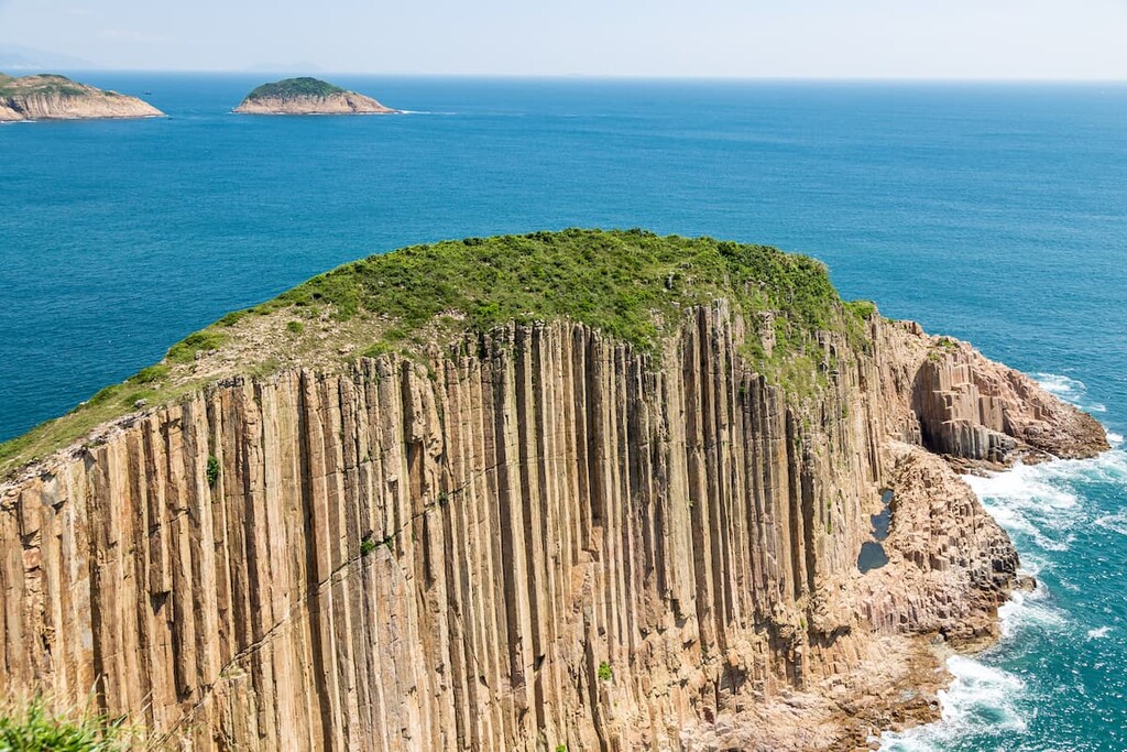
You can walk across the northern part of High Island from dam to dam by following the MacLehose Trail Section 1. Another trail from the East Dam leads to the hexagonal columns at Fa Shan, where you can go along to the easternmost part of High Island for views of the spectacular sea stack of Po Pin Chau.
Other trails will take you to old fishing villages, ruined buildings being reclaimed by nature and more coastline with wild headlands, beaches and sea caves.
Straddling Sai Kung East Country Park and Sai Kung West Country Park, Pak Tam Chung is very accessible, and it offers many short and easy hiking options.
Pak Tam Chung Nature Trail follows the Orange River, passing through mangrove swamps and Sheung Yiu Folk Museum. Sheung Yiu Country Trail passes by eerie, deserted buildings and overlooks inshore bays like the hidden Pok Wu Wan. The bay of Pok Wu Wan and its crescent-shaped embankment have become a bit of an Instagram sensation, though, so it may be busy during your visit.
To the north of Pak Tam Chung is Pak Tam Country Trail, which used to be an ancient village path with views of High Junk Peak and the islands of Kau Sai Chau, Yim Tin Tsai and Sharp Island. Pak Tam Chung is also the starting point of the MacLehose Trail if you’re looking for an additional adventure.
The stream is known for refreshing rock pools which are just a few steps from its outlet at Sai Wan. There is a series of four rock pools which offer a perfect opportunity for taking a dip. The pool at the top, which is the largest and deepest, stands under a 12-m (40-ft) cliff.
Further upstream is the 25-m (82-ft) Thousand Silk Falls. The stream is connected to Luk Wu Country Trail which leads to Pak Tam Chung. Walking along the stream can be slippery and challenging.
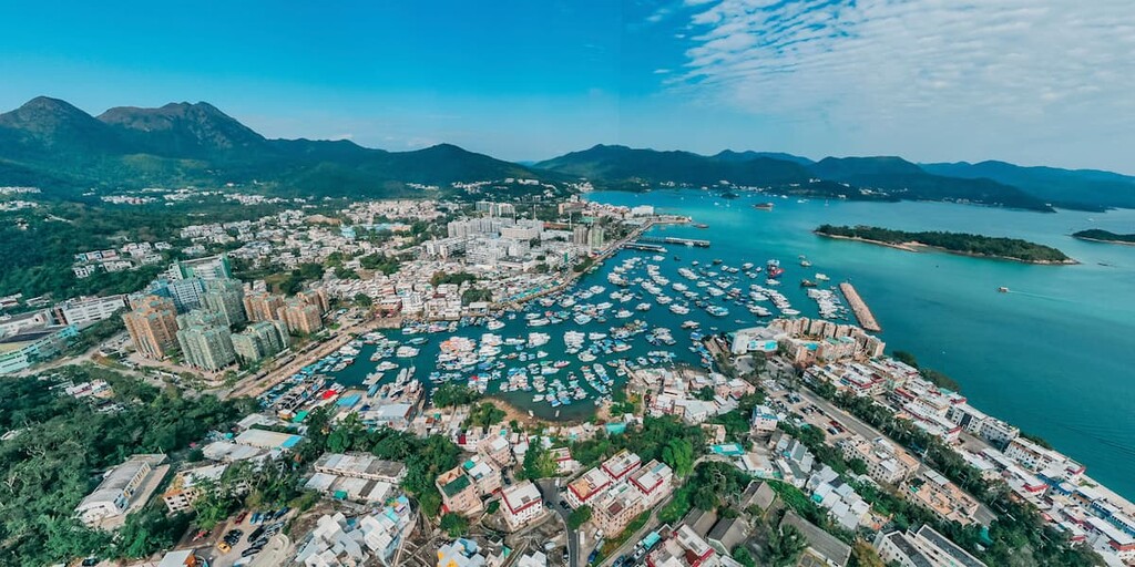
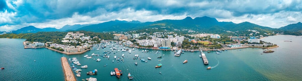
The gateway to the country parks on Sai Kung Peninsula is Sai Kung Town, a neighborhood which has mostly escaped the large-scale developments in urban areas. With its waterfront promenade and age-old villages, the town has a laid-back vibe even when it gets crowded with visitors on weekends and holidays.
The waterfront teems with seafood restaurants, specialty eateries and weekend markets which make it an appealing stopover for hikers.
To reach Sai Kung East Country Park from Sai Kung Town, take bus #94/ #96R* (*Sunday and public holidays only) or minibus #7/ #9 to Pak Tam Chung. Village bus #29R goes to Sai Wan Pavilion but departures are less frequent.