Scan the QR code and open PeakVisor on your phone
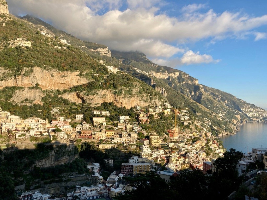
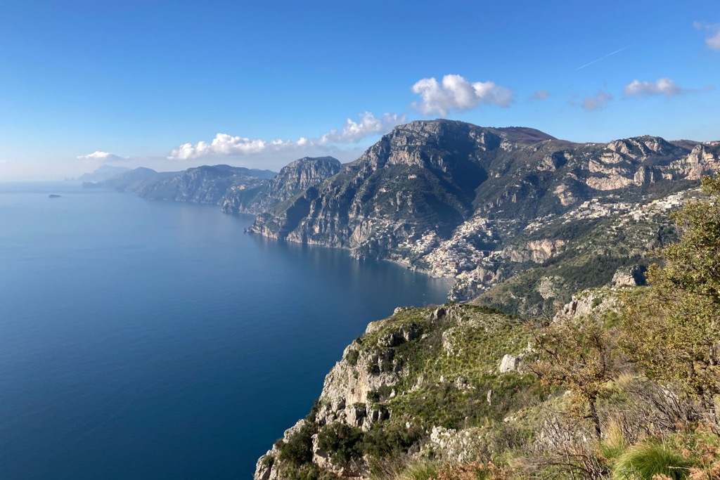
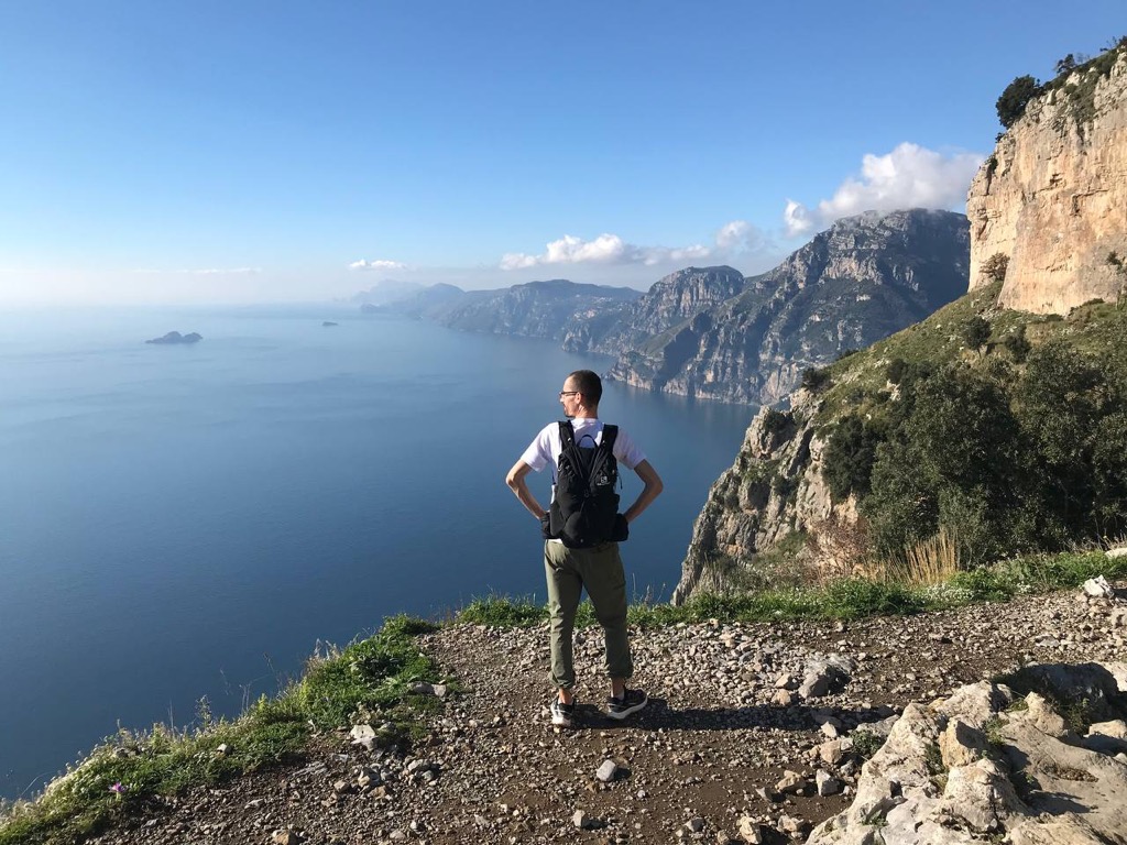
Parco regionale dei Monti Lattari (Lattari Mountains Nature Park) is one of 9 nature parks in the Campania region of southern Italy in the Apennines mountains. It's incredibly hard to pick just one main feature in the park, rather it is its geographical location in general. It covers almost the entire Sorrento Peninsula between Naples and Salerno, known a bit more as the Amalfi Coast, after a village on its southern shore. From here, the main trail of the park, Sentiero degli Dei (The God’s Path), offers the best views. The peninsula literally goes far into the sea with many high mountains one after the other, including the no less famous rocky island of Capri completing one of the best landscapes in all of Italy. There are 78 named mountains in Parco regionale dei Monti Lattari (in Italian). The highest and most prominent peak is Monte San Michele (Molare) of 1,444 m (4,738 ft).
The park gets its name from the Lattari Mountains (Monti Lattari) or Lactarii in Latin, whose name, in turn, translates as “milky” from the Italian word “latte”—the milk. This is explained by a large number of goats and cows in the mountainous areas of the park deep in the peninsula. This is such an unexpected explanation for southern Italy, as the northern Alps, not the Apennines, is much better known for their milk and other dairy products.
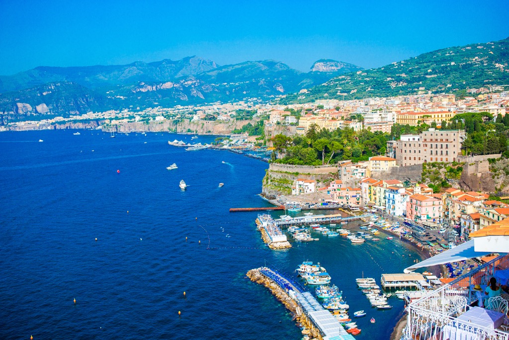
The Lattari Mountains Nature Park covers almost the entire Sorrento Peninsula from the town of Salerno in the southeast to the village of Vico Equense in the northwest. A little further west is Sorrento, which gave its name to the peninsula.
On a separate line once again: S(alern)o and S(orrent)o.
This is the first thing I had to deal with myself to navigate the park and the region because the two names are incredibly similar. More importantly, don’t confuse them—especially Sale(rn)o—with the town of Sale(nt)o. The latter is located not here at all, it is in the even more southern Apulia region between Brindisi and Lecce. So, here they are again in a list:
Remember this to remember: Sorrento has only the "o" letters and a double "rr". Salerno and Salento both begin with "sale" but end with "rno" and "nto," respectively. "Nto" is also the ending of Sorrento. Both are in the distance from Salerno with the difference that the latter is in another region. I hope this helps!
As I also already made it clear, the peninsula has two main coasts—the Sorrento Coast (Costiera sorrentina), which is washed by the Gulf of Napoli (Golfo di Napoli), and the Amalfi Coast (Costiera amalfitana), which is washed by the Gulf of Salerno (Golfo di Salerno), respectively. For this reason, it is also known as the "Peninsula of the Two Bays".
The finale of the peninsula or its most extreme point is Punta Campanella (The Bell Point), beyond which is the island of Capri, in fact, another of its peaks, cut off by water. If the mountains were higher, the peninsula would be a couple of dozen kilometers (miles) longer, that is, even more impressive. Its full length is about 65 km (mi), if you follow the southern coast.
Punta Campanella, as well as the neighboring Ieranto Bay (Baia di Ieranto), are two separate marine protected areas outside the park.
As for the mountains, the park actually covers (and protects) just the most mountainous part of the peninsula. In other words, the height of the mountains decreases as you move away from Salerno, and the highest of them is located approximately in the center of the park.
On the administrative map, the park is located between the two eponymous provinces of Salerno and Naples in the Campania region of Italy.
The easiest, closest and respectively fastest way to get to Amalfi Coast is from the city of Salerno, which can be reached by Trenitalia train from Naples, which, in turn, can also be reached from Rome.
I recommend choosing the Intercity Daytime (Intercity Giorno) train. It has fewer stops than the regional trains, more comfortable seats and generally not many other passengers. The trains also have a huge compartment for bicycles, which can be hung on special holders. But it is better to reserve a seat in advance by contacting Trenitalia by mail or phone. Important: Intercity Night (Intercity Notte) are less comfortable for travel during a daytime because of the carriages with six narrow seats.
From Salerno, there are also big intercity buses from the local Sitasudtrasporti.it across the peninsula at about hourly intervals, even in the middle of winter, which distinguishes this incredibly popular tourist destination from the lesser-known ones, which are difficult to get to in the off-season. In addition, several other companies run small buses between towns on the peninsula, which, among other things, take you to the more remote mountain villages in its interior.
The peninsula is also known as one big bike route. At least on my trip, I saw several hundred cyclists while simultaneously wondering, “How do they even ride here?” The fact is that the peninsula is incredibly populated (yes, the word "incredible" describes Amalfi well) with many villages, but its mountainous landscape does not allow for wide roads here. Hence there is always heavy traffic—cars have to pass each other and are constantly signaling on corners. It takes at least 2.5–3 hours to get from Salerno to Sorrento by car or bus, even though it’s just over 50 km (31 mi) long. I also got very carsick on the bus, and, to be true, sometimes just scary when it drove right by the precipice.
Going back to winter, it is the best season for a trip to Amalfi, because there are far fewer tourists and the weather is better for hiking. During my trip in mid-December, it was +20 degrees Celsius (+68 Fahrenheit). In contrast, during the peak season, it will be +35 degrees Celsius (+95 Fahrenheit), and the trail and buses will be crowded for sure, as well as towns, restaurants and hotels.
To get to Sorrento from Naples is a bit more long and difficult: you need to use local trains and buses—there is also no direct train to the coast.
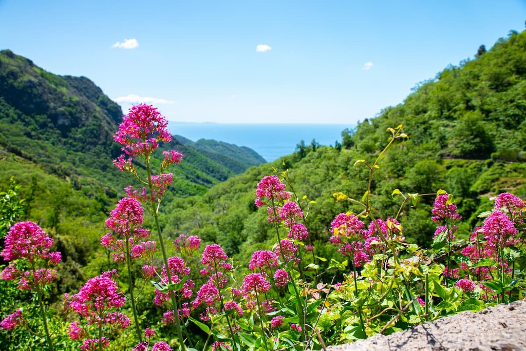
The characteristic flora of this region is largely the same as that found throughout southern Italy: Mediterranean scrubs on the coast, and beech and mixed forests deep in the mountains. There are also many cypresses and olive groves. It's all mostly green, even in winter or just painted in fall colors, when in northern Italy the trees have been standing bare since the end of November. Here too, however, individual species fall off completely.
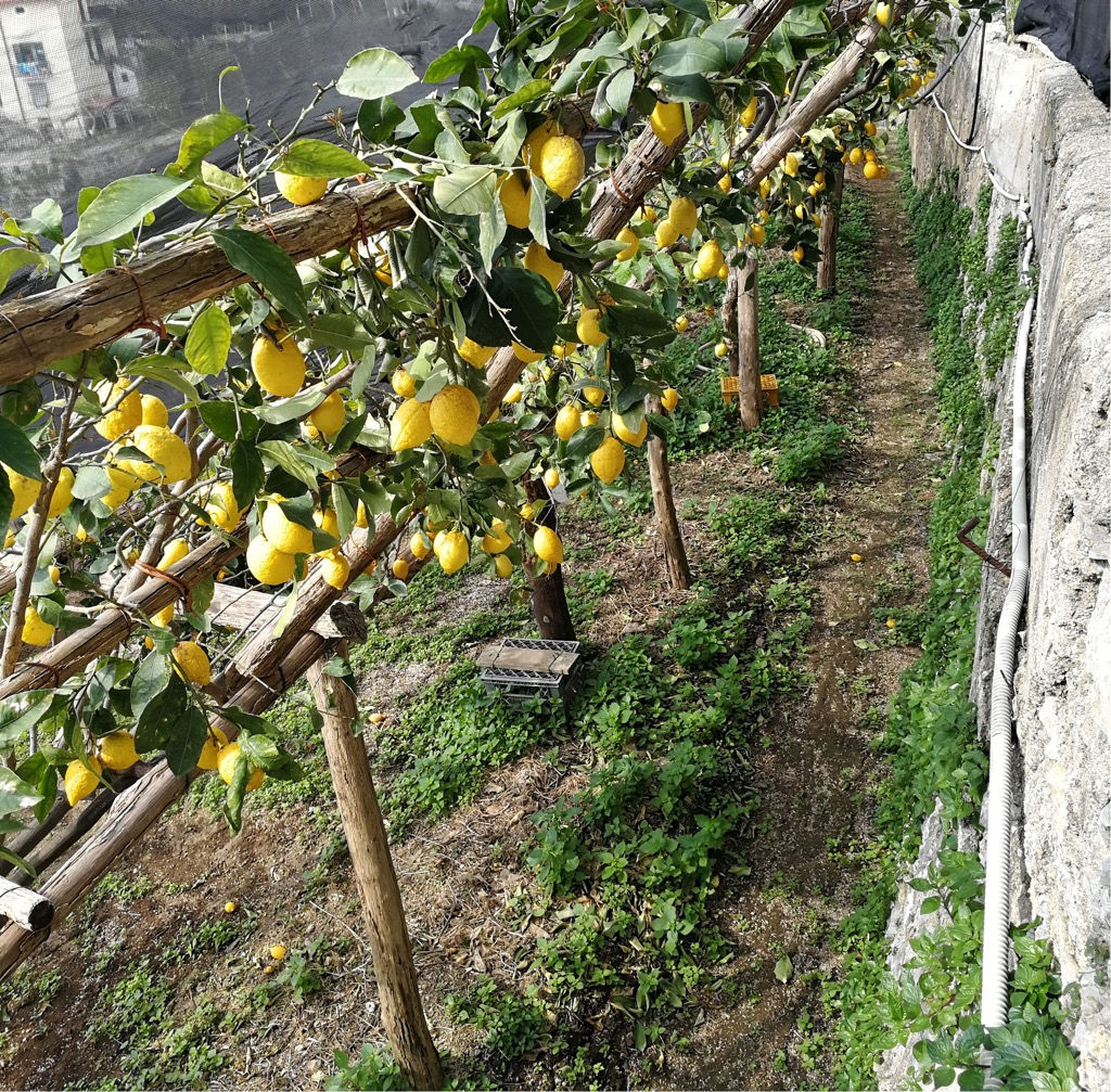
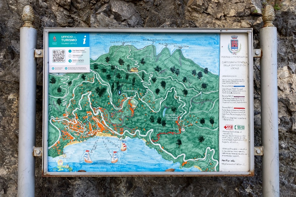
A special feature of the Amalfi Coast is that lemons grow well here. Most of them can be found on the artificial terraces between the neighboring towns of Maiori and Minori, between which there is even The Lemon’s Path (Sentiero dei Limoni), the first and most uncomplicated of the more than five main trails of the park. From the latter, it is also possible to reach Amalfi via city streets and trails.
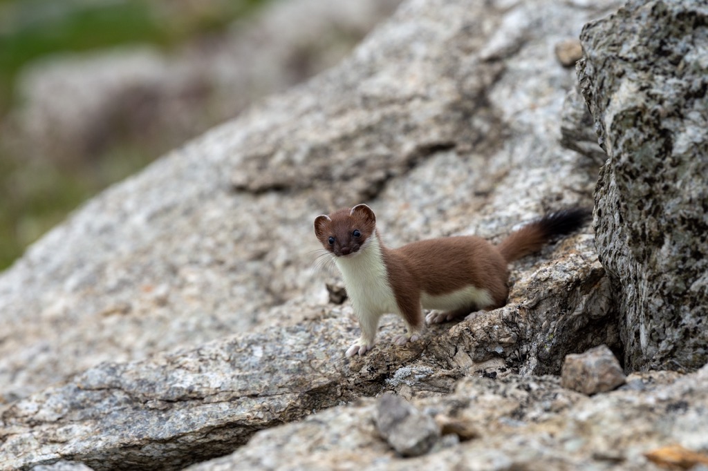
Of the animals in the Lattari Mountains, you have a better chance to meet various birds: buzzard, kestrel, peregrine falcon, herring gull, imperial raven, lonely sparrow, and others. Among the mammals, there are fox, weasel, beech marten, hedgehog, otter, and others. To see some of them, you definitely have to hike deep into the mountains, not along the coast.
The Lattari Mountains are part of the larger Campania Antiappennines (Antiappennino campano), which includes several other subranges and individual mountains such as Vesuvio. These, in turn, are part of the Antiappennines (Antiappennino) in the classification of this mountain system by the longitude (west to east) as opposed to latitude (north to south).
The mountains of the Sorrento Peninsula consist of three pronounced subranges: the central—the highest one; the eastern—the most extensive one; and the western—the "flattest" one, going into the Tyrrhenian Sea. (Although officially the park is divided differently: into eight zones according to the settlements of Agerola, Amalfi, Angri, Corbara, Maiori, Positano, Scala and Vico Equense.)
The central part is a single mountain ridge, stretching north-south across the peninsula between the towns of Castellammare di Stabia and Praiano, respectively. It includes the highest peak of the park and of the entire peninsula, Monte San Michele (Molare) of 1,444 m (4,737 ft), which is located above the town of Arienzo. Other notable peaks in the ridge above 1,000 m (3,280 ft) are Monte Tre Calli (1,222 m / 4,009 ft), Monte Catell (Caldara) (Caldara) of 1,390 m (4,560 ft), Croce della Conocchia (1,387 m / 4,550 ft), Monte Cerasuolo (1,214 m / 3,982 ft), and Monte Faito (1,147 m / 3,763 ft). The latter can be reached by cable car from Castellammare di Stabia, while the former can be reached on foot from the mountain village of Bomerano, a hamlet of Agerola. All the mountains between can also be hiked one after the other except for the section between the two highest peaks (the second is Monte di Mezzo (Canino) of 1,426 m (4,678 ft), so there is no trail at all. Anyway, in the southern part from Monte Tre Calli to Monte di Mezzo it is a very difficult trail for advanced hikers only, as it goes through a narrow ridge on both edges of which is the abyss where you don't want to disappear. But in the northern part the trail to Monte San Michele from the cable car via Monte Faito is considered easy, mostly anyone can do it. Check Caimontilattari.it for a detailed free online map.
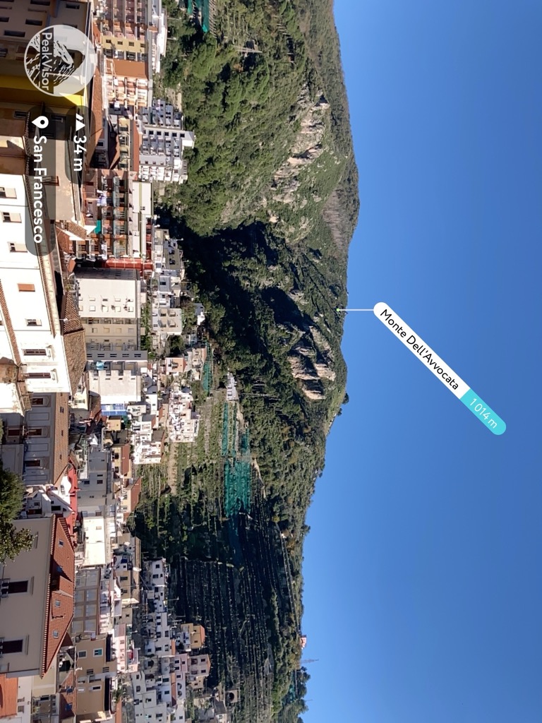
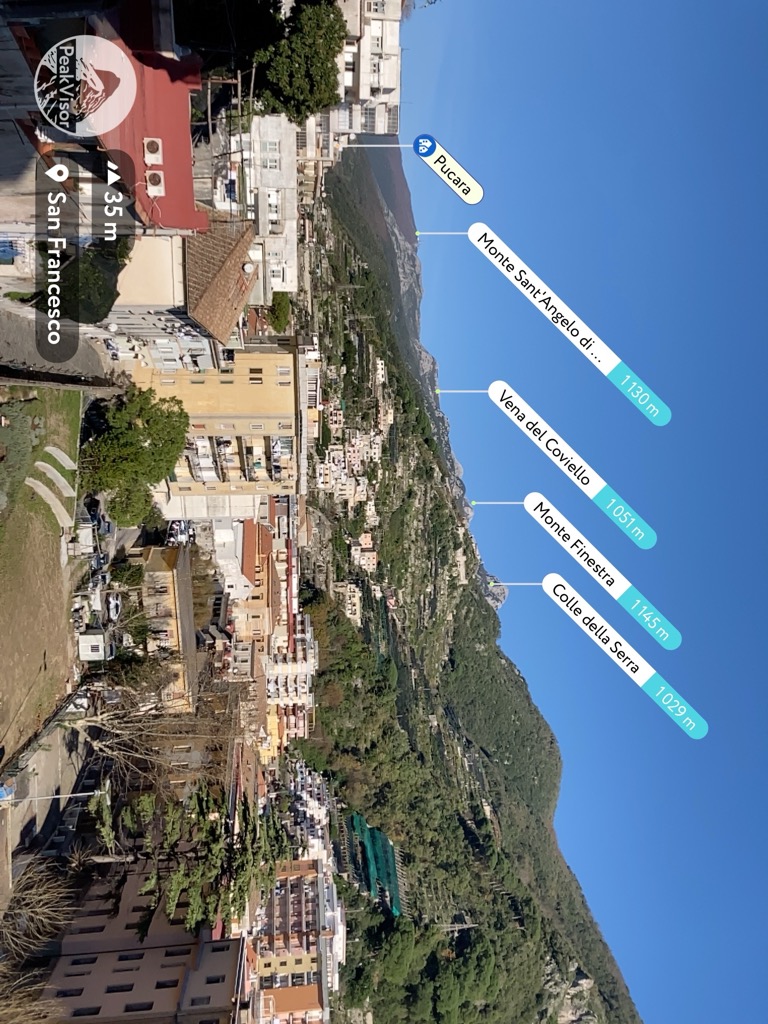
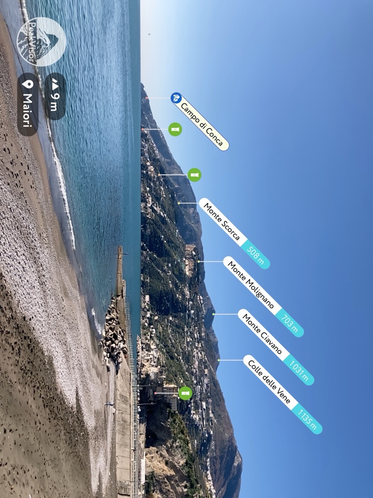
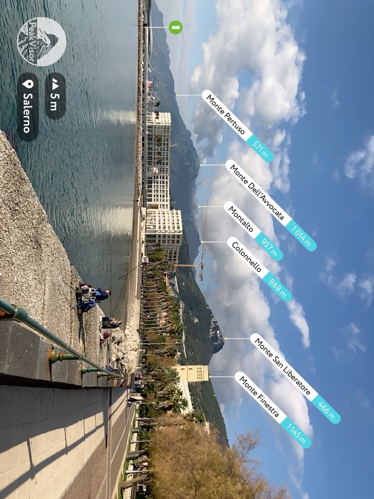
The eastern part of the range is in turn three times wider. It composed of two major parts — the western with the dominant mountains of Monte Cerreto (1,313 m / 4,307 ft) and Monte Candelitto (1,201 m / 3,940 ft), which are accessible for a regular hiker; and the eastern closer to Salerno with the dominant mountains of Monte Finestra (1,145 m / 3,756 ft)—but this one again expert-only, and Monte dell’Avvocata (1,014 m / 3,326 ft), visible from the waterfront of the city of Salerno.
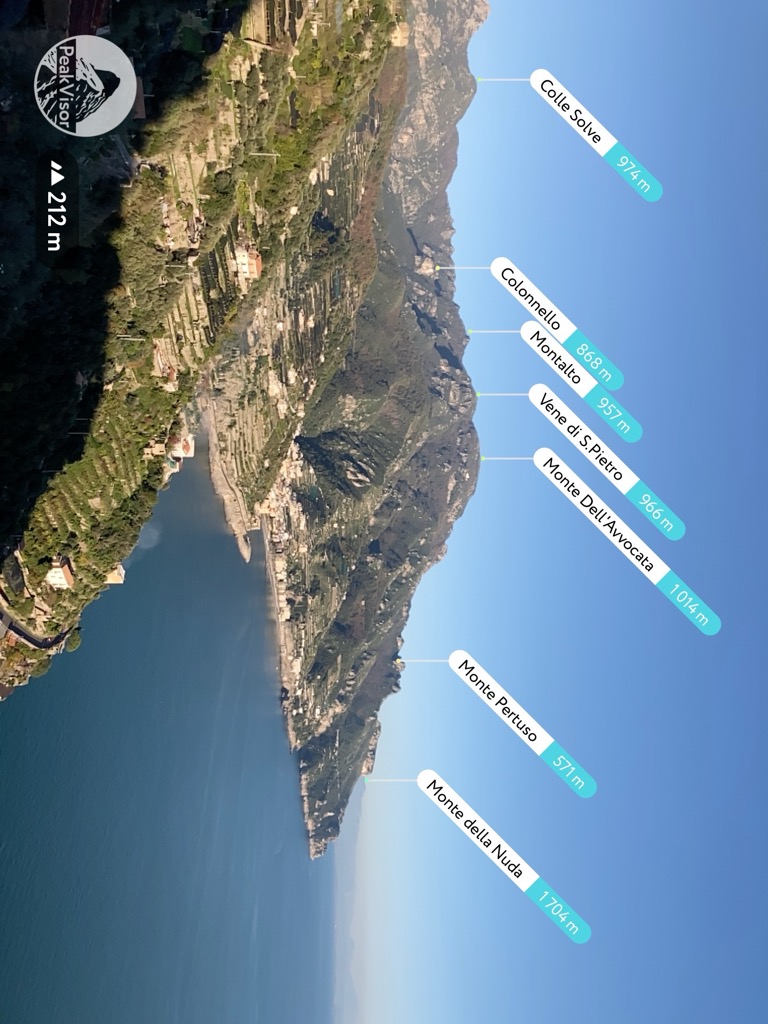
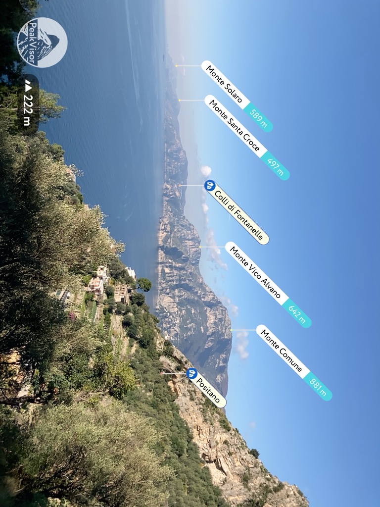
The western part is inferior to the eastern part, but superior to the central part. It is the lowest and mostly out of the park. The westernmost mountains of the peninsula are Monte Santa Croce (497 m / 1,630 ft) and Monte San Costanzo (486 m / 1,535 ft). If you take the boundaries of the park, it is Monte Vico Alvano (642 m / 2,106 ft). The highest mountain on the island of Capri is Monte Solaro (589 m / 1,932 ft).
In summary, the Lattari Mountains are a large and high mountain range with many interesting and beautiful peaks, as well as rich and unique flora and fauna within the nature park, which can be explored for months both virtually by reading guides like this and on foot, which of course is even better. However, it seems like they are unfairly overshadowed by the Amalfi Coast itself, which beckons travelers with sea views. Really, have you heard of Lattari before? But now you do.
The Lattari Mountains has a vast network of trails covering literally the entire park and the entire peninsula. In addition to the aforementioned trails, there are at least three other main ones worth mentioning:
Sentiero degli Dei (The God’s Path) is the main and most popular trail in the park. Its main feature is that it offers the best view of the peninsula, going for many kilometers (miles) into the sea. It has two beginnings and one finish. The trail can either start in the mountains at Bomerano, a hamlet of Agerola, or on the coast at Praiano. The difference is that in the first case you will descend all the way down to the coast, in the second you will climb 500–600 m (1640–1,968 ft). In the second case, you will also pass the religious part of the trail intended for pilgrims, from which its name comes, to the convent of Saint Domenico (Convento di San Domenico)—one of the most impressive churches I’ve seen in my life because of its located on the high plateau. The finish of the trail is at Positano. In both cases, the trail is about 10 km (6 mi) long, which can be hiked leisurely in about 5–6 hours with stops.
Valle delle Ferriere Nature Reserve (Riserva naturale Valle delle Ferriere) is the only separate natural area within the nature park. As its name suggests, it protects the Ferriere, the deepest and one of the largest inland valleys of the Monti Lattari, which begins on the coast from the town of Amalfi. The valley is famous for its rich water sources such as streams with many rapids and waterfalls and its historic paper mills built on it. From the town, the reserve is accessible via four marked trails the shorter of which is 6 km (3.7 mi) of 2–3 hours of hiking. Learn more about it and other features of the reserve in a separate guide following the link.
Hike to Punta Campanella is probably the easiest route of the Parco Regionale dei Monti Lattari, although technically the westernmost tip is not part of the park. It takes more than 20 km (12.4 mi) to get to the cape from Sorrento, so it is better to go to the village of Termini, nearest to it, by local bus. There you can take a circular route of about 10–15 km (6–9 mi), depending on the exact combination of trails. On it, you will also find several other places of particular interest, such as the two watchtowers, Torre di Fossa Papa and Torre di Montalto, a distinctive feature of the maritime architecture of Sorrentino Peninsula in particular but also southern Italy in general.
Before 2016, there was Laceno–Bagnoli Irpino ski resort near Naples but it has been temporarily closed since about 2016, so there are no ski resorts in the Campania region.
The main ski areas near Naples are now located in different regions. These are Campitello Matese with more than 20 km (12.4 mi) of slopes and more than 5 ski lifts in the province of Campobasso of the Molise region to the north of Naples and Monte Sirino with more than 5 km (3 mi) of slopes and more than 5 ski lifts in the province of Potenza in the Basilicata region to the south of the city.
Check the Italy ski resorts map in the World Mountain Lifts section of the site. It includes information about open ski lifts / slopes in Italy in real-time with opening dates and hours. There are also year-round cable cars, funiculars, cog railways, aerial tramways, and all other types of mountain lifts.
If you are at Sorrento Coast, don't miss the official Visit Center of the park where you can take a map, ask advice, buy some presents for your friends, and so on.
Centro Visitatore Parco Regionale dei Monti Lattari
Palazzo Reale, Viale Ippocastani, località Quisisana, Castellammare di Stabia, 80053, Campania, Napoli (NA), Italy
Monday to Friday from 9 am to 4 pm
+39081930247
info@parcoregionaledeimontilattari.it
Parcoregionaledeimontilattari.it
In case of emergency on the trail call 112 or 118 or +39331459777.
Within Lattari Mountains Nature Park, you should have no problem finding lodging. Again considering that this is a densely populated peninsula, there are all kinds of options from hostels and B&Bs to hotels and villas, of which there seem to be as many as regular private homes.
Understandably, for hiking along the coast or nearby mountains like Tre Calli, the best option would be to rent lodging in one of the towns by the sea. For example, during my hikes in the park, I stayed in Amalfi Luxury House, which I highly recommend. To get deep into the mountains and not waste time on the bus, it’s better to find something in one of the villages in the center of the peninsula.
You can also make the lodging a base for hiking and stay there for several days, or you can spend the night in a new place each time and come to it literally on foot from the previous one, walking along the entire coast or across it. This is also one of the great features of Amalfi, which has many settlements almost uninterruptedly connected to each other by a network of roads and streets.
So, as it is already clear, the Parco Regionale dei Monti Lattari and the whole Sorrento Peninsula are covered by a series of small towns and villages. In addition to what I have already told you, I will add a few insights from my personal experience of hiking on the Amalfi Coast:
As a result, Amalfi is considered the premier city on the coast for a reason. It is optimal in terms of location, size, and attractions of both types: natural and cultural.