Scan the QR code and open PeakVisor on your phone
Scale the peaks of the Simbruini mountains and experience vast beech woodlands, karst plateaus, spring waters, and historical towns in Parco Naturale Regionale dei Monti Simbruini, a protected haven in the Italian Apennines. There are 110 named mountains in Parco Naturale Regionale dei Monti Simbruini. The highest and most prominent mountain is Monte Viglio.
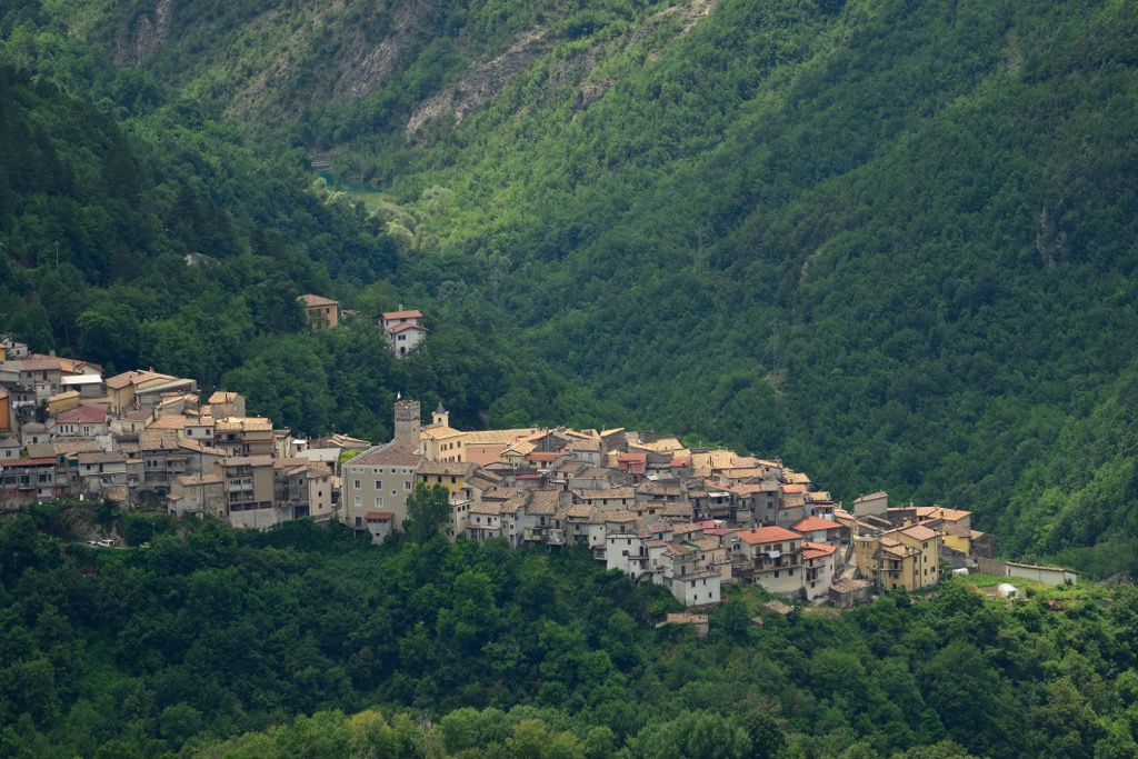
Located in central Italy, Parco Naturale Regionale dei Monti Simbruini spans 300 sq. km (116 sq. mi) across the provinces of Frosinone and Rome in the region of Lazio. It encompasses the seven municipalities of Cervara di Roma, Camerata Nuova, Subiaco, Jenne, Vallepietra, Trevi nel Lazio, and Filettino.
The park is located between the Aniene valley to the northwest and the Sacco valley to the southwest. The eastern border of Parco Naturale Regionale dei Monti Simbruini runs along the regional border with Abruzzo, and the Ernici mountains are found towards the southeastern border of the park.
The park’s territory is mainly mountainous and characterized by two rivers, the Aniene and Simbrivio. The most notable summits of the Simbruini mountains are Monte Viglio, Monte Tarino, and Monte Autore.
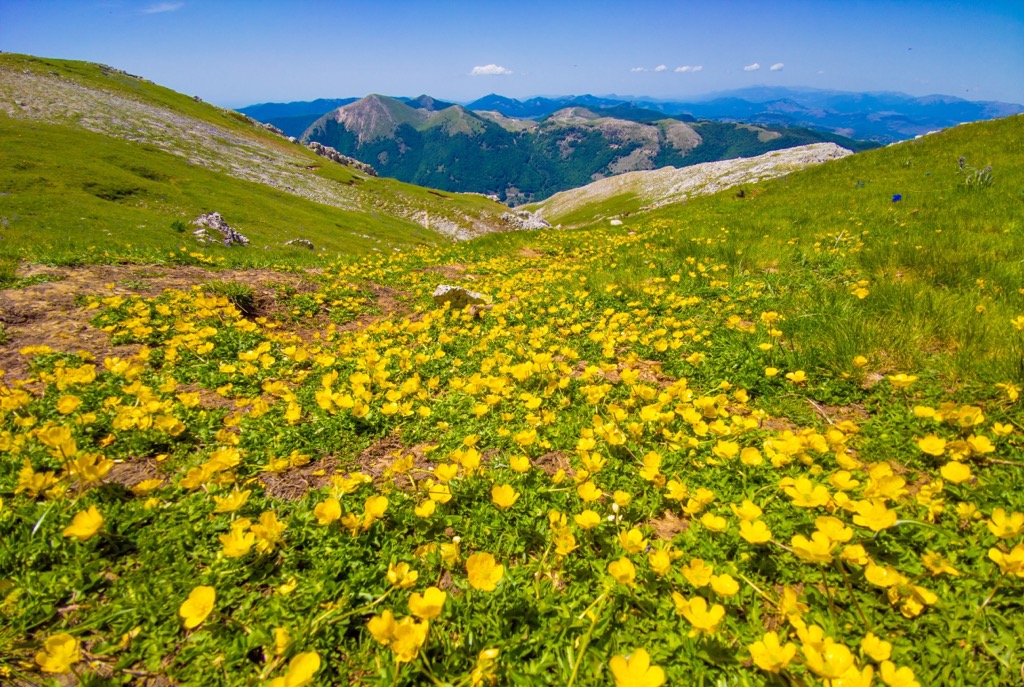
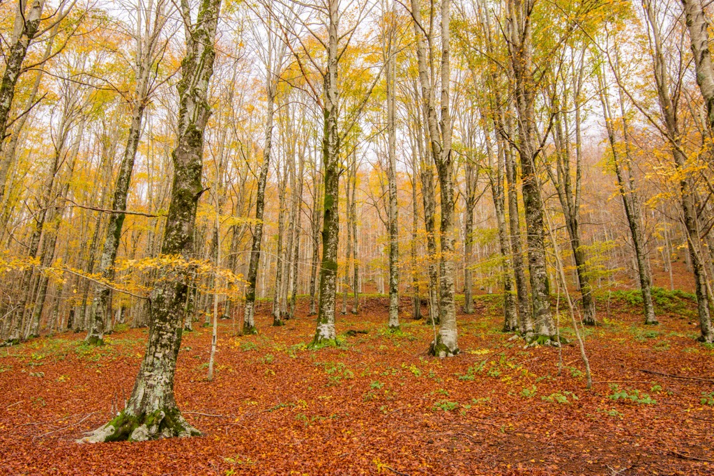
The mountain chain alternates between karstic plateaus, flat areas, and gentle slopes covered in beech woods where you can find sinkholes, thanks to water erosion over the centuries. Simbruini derives from the Latin Sub Imbribus, which translates as “under the rain”, referencing the important role water plays in the area.
The Simbruini Mountains were formed between 220 and 60 million years ago and consist almost exclusively of outcrops of Mesozoic units in carbonate platform facies. There are some outcrops of more recent deposits and different limestones can be found on the northern periphery of the ridge. There are siliciclastic deposits in the southeastern part of the Aniene valley northeast of the Roveto valley, and north of the Carsoli plain.
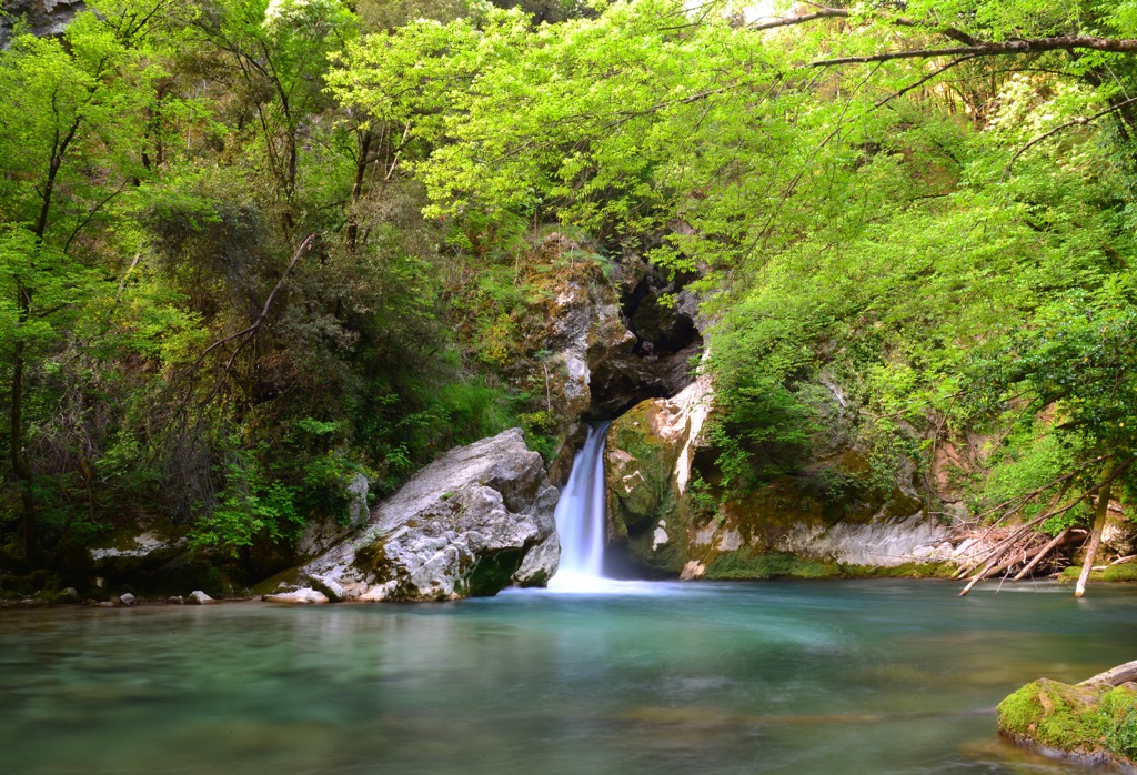
Thanks to its abundance of water, the park is characterized by numerous karstic depressions and sinkholes where water flows underground leading to numerous springs and waterfalls lower down the valley.

This in turn has meant that the park is a hotspot for speleological activity. Lazio’s speleological groups have massively contributed to the speleological knowledge of the area in recent years and one of the best-known caves in the park is Grotta dell’Inferniglio in Jenne.
Although it's just an hour away from Italy’s bustling capital city, Parco Naturale Regionale dei Monti Simbriuni provides an abundance of flora and fauna. The park is home to several animal species that are characteristic of the Apennines, as well as vegetation of great environmental value.
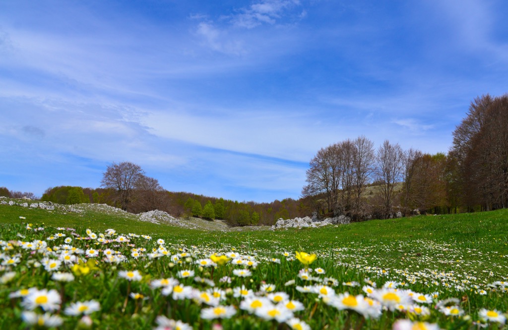
The flora in Parco Naturale Regionale dei Monti Simbruini is characteristic of both central Europe and the Mediterranean coast. The highest summits in the park are covered with subalpine vegetation and most of the territory is dominated by woodlands, the largest of which are the beech woods that grow between 900 m and 1,900 m (2,950 to 6,200 ft).
Here beech trees grow alongside European rowan, sycamore maple, Norway maple, yew, and holly. Below the vast beech woods are a variety of pure and mixed woodlands comprised of deciduous oaks such as Turkey oak, downy oak, and hop hornbeam. You can also find other species here such as the flowering ash, field maple, and Italian maple.
Wild boar, roe deer, two wolf packs, and sometimes the very rare brown bear roam the vast woodlands and peaks of the park. There is also an active program to slowly start introducing red deer to rebalance the population in favor of the two big carnivores. In total there are around 57 protected species in Parco Naturale Regionale dei Monti Simbruini.
The park also provides nesting sites for 105 bird species, 12 of which are birds of prey. Among the birds of prey are the sparrowhawk, buzzard, goshawk, tawny owl, barn owl, and little owl. Other birds you may spot in the park include the jay, great spotted woodpecker, and white-backed woodpecker. Rock partridges also roam the park close to the mountain peaks.
The park’s wetlands are populated by amphibians such as the spectacled salamander and fire salamander, along with the spotted newt and crested newt. Here you’ll also find bird species including herons, yellow wagtails, dippers, and mallards, as well as mammals such as the water shrew.

Humans have lived in Lazio and the Apennines for centuries, with evidence in the park dating back to the fourth and fifth century BCE. This is demonstrated by the ancient walls of Filettino and the ruins of the town of Camerata, which was destroyed by a fire in 1859.
The area is best known for its ancient Roman history, evidenced by a villa built by Emperor Nero near Subiaco along the river Aniene where he also built three artificial lakes and aqueducts to supply Ancient Rome with water. The park’s springs still provide Italy’s capital with fresh drinking water today.
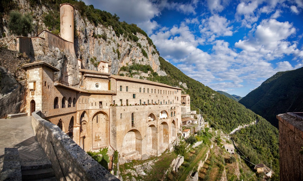
Subiaco is also home to St. Francis abbey (1327), a Medieval bridge (1356), the triumphant arch (1787), Basilica Sant'Andrea Apostolo (1789), and the district where Cesare and Lucrezia Borgia were born. Finally, the nearby village of Cervara is an open-air museum with a variety of sculptures carved into the rock, alleys, and staircases.
The Santuario della Santissima Trinità, a sanctuary built into the rock of the mountainside in Vallepietra, is also an important site and destination for pilgrims and hikers alike.
Experience beech woods, karst plateaus, and a wealth of history when hiking in Parco Naturale Regionale dei Monti Simbruini. A network of over 40 paths covers the park allowing hikers to experience all of the different natural environments.
All paths are marked with white-red flags and each path corresponds to a number on the path guide map. Opt for multi-day treks crossing the park, a variety of day hikes, mountain biking, horse riding, or even snowshoeing and skiing in the winter. There are two ski resorts in the park with 15 km of ski pistes.
Here are some of the biggest routes that cross the park:
The high route can be carried out in three different stages:
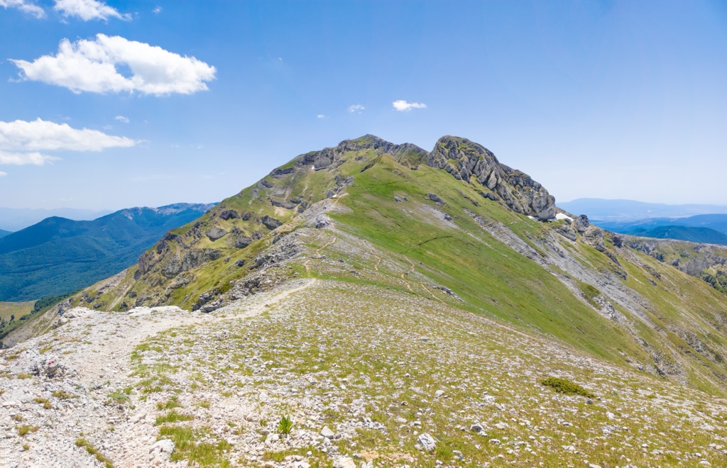
This route offers panoramic views over the park and is almost entirely on the ridge. The best time to hike this route is from late spring to early fall to enjoy the surrounding nature. Snow equipment is required during the winter months. Each section is relatively easy with a good base level of fitness, although the last stage is longer and more arduous.
The Grande Anello del Faito (Great Faito Loop) is a three-day hike around the heart of Parco Naturale Regionale dei Monti Simbruini. Slow down and take in the beautiful panoramas over the park while enjoying the local nature. The route crosses the three villages of Vallepietra, Trevi nel Lazio, and Filettino.
Start in Vallepietra in the direction of Trevi nel Lazio to warm up with the first two stages before tackling the trickier final stage from Filettino.
The way of the Abbeys (Il Cammino delle Abbazie), is set over nine stages and follows in the footsteps of Saint Benedict, the Patron Saint of Europe. The route passes through several historical villages such as Subiaco, Alatri, Veroli, Monte San Giovanni Campano, and Arpino. It also passes by seven important religious monuments: the Monastery of St. Scolastica, Sacro Speco, the Charterhouse of Trisulti, the Abbey of St. Sebastian in Alatri, the Abbey of Casamari, the Abbey of San Domenico in Sora, and finally the Abbey of Montecassino in Cassino.
Each stage is around 15 km (9.5 mi) and highlights the typical environments of the Apennine mountains, as well as the historic and religious heritage of the area. You can walk, bike, or horseback ride along the route, which spans a total of 150 km ( 93 mi).
The way of the wolves (via dei lupi) is a 14-stage journey across Lazio and Abruzzo that follows in the footsteps of the area's best-known but rarely-seen mammals. The route starts in Tivoli, just outside Rome, and travels through Parco Naturale Regionale dei Monti Simbruini and The National Park of Abruzzo, Lazio, and Molise (Parco Nazionale di Abruzzo, Lazio e Molise) before ending in San Donato in Valle di Comino. Following this route, you’ll experience the Roman countryside, the wide plains of the Tiber, mixed woodlands, karst plateaus, pastures, and mountain peaks.
Pick from a wide range of accommodation within the park to get a better sense of the surrounding nature. There are plenty of options from farm stays and guesthouses to hotels, bed and breakfasts, and holiday rentals. Check out some of the main towns to use as a base when visiting the park:
Built on a rocky cliff, the medieval town of Subiaco offers spectacular views over the Aniene valley. From here you can visit two Benedictine monasteries, Santuario del Sacro Speco, and Abbazia di Santa Scolastica, and explore the town’s ancient streets and churches. Head just outside the town to visit the remains of Roman Emperor Nero’s villa, or lace up your hiking boots and head out for a walk in the Apennines.
Vallepietra is a great base to explore the park’s hiking network and visit the nearby Sanctuary of the Holy Trinity (Santuario della Santissima Trinità), built into the cliffside. If you’re looking to relax, you can also reach the nearby healing thermal waters of Fiuggi.
Rome is the perfect base if you’re planning on visiting the park for a day trip. There’s plenty to keep you occupied within the city itself, from visiting the Roman Forum, Pantheon, and colosseum, to stumbling upon beautiful piazzas, indulging in the delicious local cuisine, and people-watching from one of the many bars. Or if you want to escape the crowds and experience the nearby nature, you can reach the park by car within an hour, or visit the nearby Parco dei Castelli Romani.