
Scan the QR code and open PeakVisor on your phone
The beauty is in the eyes of the beholder, yet Synevyr is so pretty that it would be a feast to any eyes however fastidious they might be. The National Nature Park Synevyr (the Carpathians) attracts tourists not only from nearby countries but even from the USA, France, Great Britain, Austria and Canada – the countries that enjoy plenty of natural attractions themselves. People are ready to travel halfway around the world to visit the Synevyr.
Who knows what draws people here, it might be the famous legend of alpine lake Synevyr, or ancient architectural sights, or the beauty of the Ukrainian Carpathians. Here you can enjoy the silence of the pristine world, breathe pure fresh air filled with the aroma of pine trees and various herbs, drink crystal clear water from mountain rivers and springs, and enjoy the fabulous scenery.
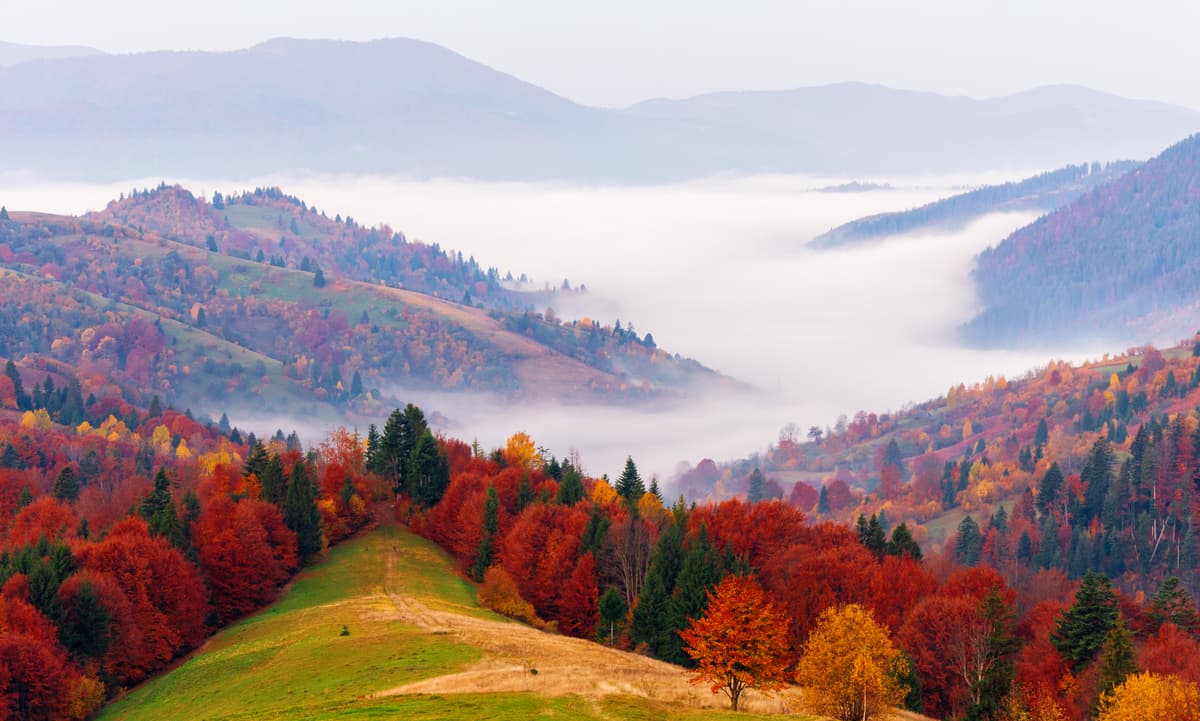
The Carpathians are a mountain system in Eastern Europe in the Czech Republic, Slovakia, Hungary, Poland, Romania, Serbia, partly Austria, and Ukraine. It is about 1,500 km long and up to 2,655 m high (Gerlachovský štít aka Gerlach Peak is the highest peak in the High Tatras, Slovakia). The Carpathians stretch from the outskirts of Bratislava to the Iron Gates in Romania thus forming a convex northeastward arc. The Eastern Carpathians are in Ukraine. The Ukrainian Carpathians are located in the west of Ukraine mainly in Lviv, Ivano-Frankivsk, Zakarpattya and Chernivtsi regions. The Ukrainian Carpathians consist of five main ridges: the Marmorochynska, the Chernogor, the Svidovetskiy, the Gorgan, and the Borzhav ridges. The highest of them is the Chernogor with an average height of 1,800 m. Close to villages of Yasinya and Yablunitsa there is the highest point of the Ukrainian Carpathians – Hoverla Mountain and nearby is Petros and Pop Ivan.
The Ukrainian Carpathians stretch from north-west to south-east for almost 280 km with an average width of 100 km. The absolute heights of the mountain range vary from 120-400 m at the foot of the mountains to 500-800 m in intermountain depressions and to 1500-2000 m along the main ridges. The highest peaks are a part of the Chernogor massif: Hoverla (2,061 m), Brebeneskul (2,032 m), Pop Ivan (2,020 m), Petros (2,020 m), Gutin-Tomnatik (2,016 m), and Rebra (2,010 m).
The Synevyr National Park is located on the territory of the Ukrainian Carpathians. The name to the park was given by a gorgeous mountain lake Synevyr. Firstly, the authorities created the landscape reserve in 1974 around the lake, then in 1989, National Nature Park Synevyr took under protection a number of other valuable natural sites in the upper Terebovlyansky valley of the Mizhhirya district of the Zakarpattya region.
The area of the National Park is 43 hectares. There are 53 species of plants and 43 species of animals listed in the Red Book of Ukraine. The nature park is located in the western part of the Gorgan and most of it belongs to the highlands (440-1,719 m). The relief of the park is varied, there are alpine meadows and sharp peaks and ridges. The highest mountains are Strymba (1,719 m), Nehrovets (1,707 m), Kanch (1,579 m), Tapesh (1,324 m), Darvayka (1,502 m), Ozirna (1,496 m), Barvinok (1,461 m), Popadia (1,448 m), Velyky Gorgan (1,438 m), and Sekul (1,389 m).
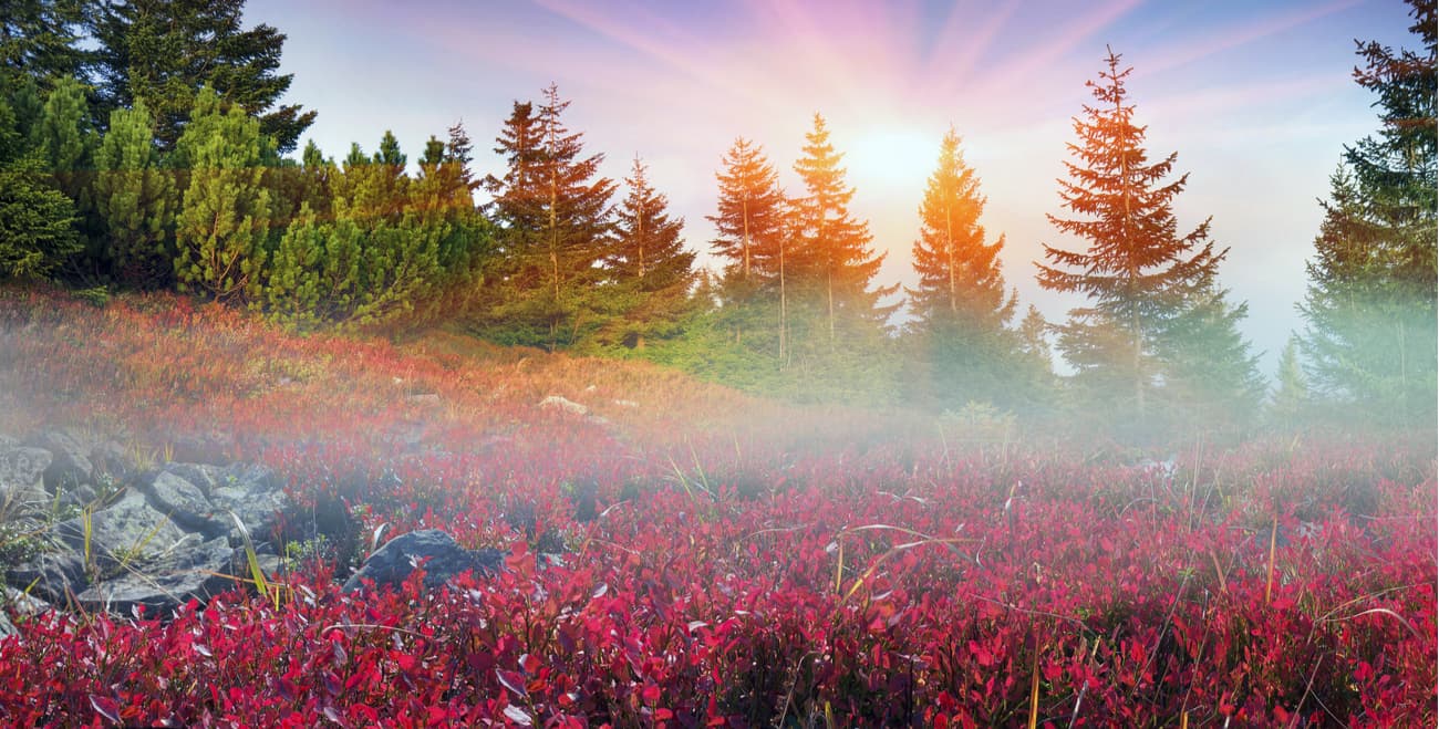
Apart from good mountains, there are gorgeous water basins here, i.e. lakes Synevyr and Ozirtse (aka Wild Lake). Wetlands cover an area of 36.4 hectares. Oligotrophic bog Hlukhanya is the largest sphagnum bog in the Gorgan mountains, that marshland covers an area of 17 hectares, and is located at an altitude of 620 m. There is another oligotrophic sphagnum bog in Synevyr — Zamshatka (4,2 hectares), which due to its vegetation composition and type of nutrition is considered to be a raised bog of a spherical shape. Picturesque landscapes, jolly brooks, powerful waterfalls, evergreen forests, you name it, the Synevyr has it! All these mighty nature frolics attract travellers from around the world.
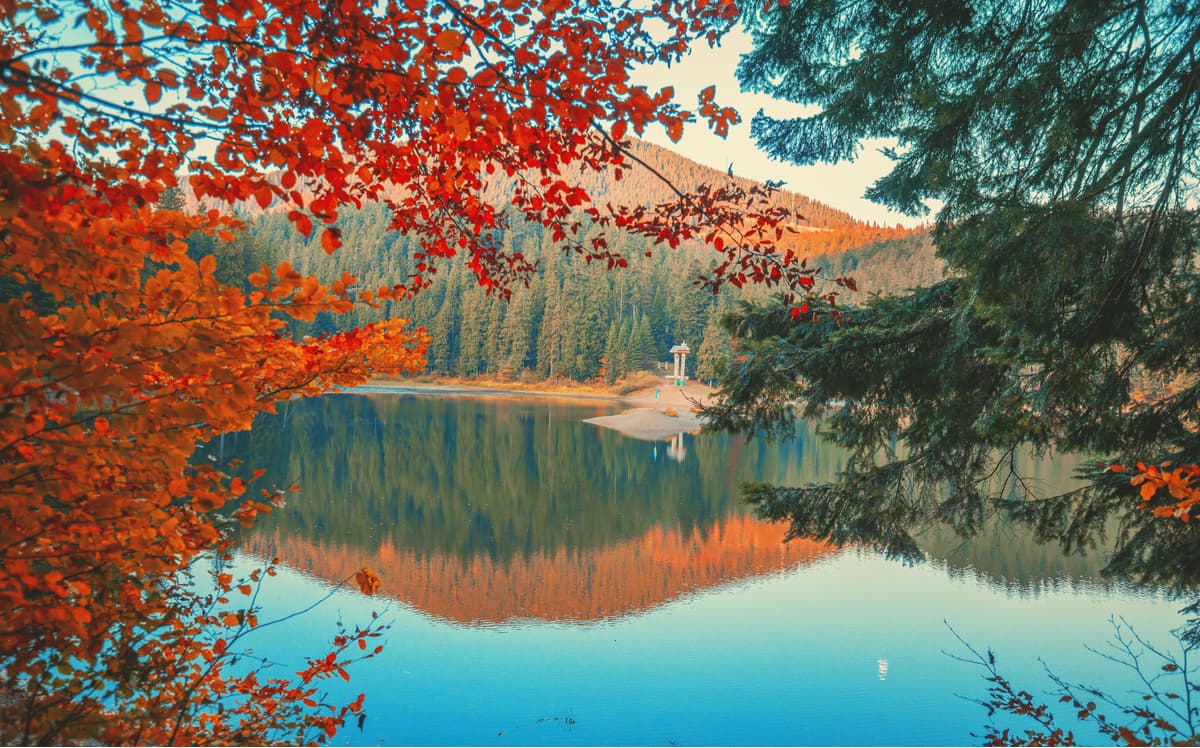
Lake Synevyr is the largest lake in the Ukrainian Carpathians and one of the Seven Wonders of Ukraine. It is snuggly tucked between the mountains, in the middle of a spruce forest at an altitude of 989 m above sea level on the southern slopes of Gorgan in the hollow formed by mountains Ozirna (1,495 m) and Slenizor (1,235 m) and the spur of the watershed ridge. The area of the lake is 7 hectares, the average depth is 16-17 m and the maximum depth is 24 m. The lake is fed by surface and atmospheric waters. The water is clean, transparent and slightly mineralized. The lake is home to a number of freshwater crustaceans. The crystal clear waters of the lake create the perfect ambience for many trout species, viz. the lake, rainbow, and brook trouts.
There is a legend according to which the picturesque lake was formed by a flood of tears shed by the Count's daughter Sin (it is just a name, nothing vicious here) in the place where her beloved, called Vir, a commoner and a shepherd from Verkhovna, was killed with a stone block by the orders of the treacherous Count. In fact, Lake Synevyr was formed by a powerful landslide caused by an earthquake about ten thousand years ago. At an altitude of 989 m, the stony rocks cluttered the way of a fast stream thus forming a dam and completely blocking the narrow valley. The giant gorge that emerged in the process was filled with water from three mountain streams.
Lake Synevyr is called The Pearl of the Carpathians. Indeed, if you climb any of the nearby mountains and cast a glance over the lake from a bird's eye view, you can see a picturesque landscape, the bright blue water surface is reflecting the green thick of the surrounding forests, and there is a small island in the middle. The lake is surrounded by beeches and firs. The trunks are thick; it would take more than one person to measure their circumference. The water in the lake is so clean that you can see the bottom. From far away, the water seems bright blue. The area of the water cover is 5 hectares. In the middle, there is a tiny island that looks like the apple of a huge eye, hence the popular name of the lake - Sea Eye. At the bottom of lake Synevyr, there is an opening which serves as a kind of natural regulator of water level and thanks to which the lake does not overflow its shores even during floods. The lake has an observation deck from which you can enjoy all the beauty of nature.
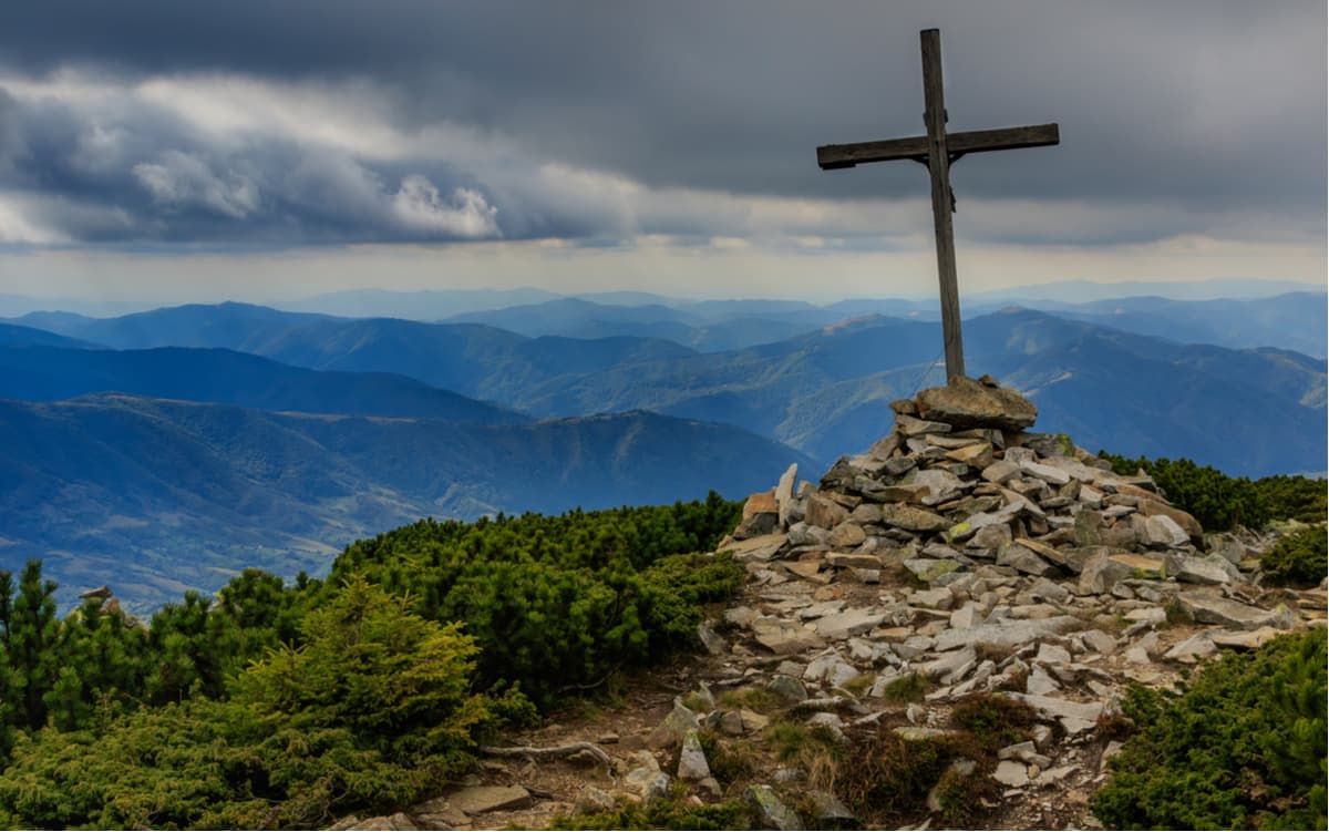
Mount Strymba (1,719m) is one of the largest mountains in the Carpathians and the most beautiful peaks of Mizhhirya district in the Zakarpattya region. It is very popular with tourists. The conquest of the mountain will be remembered for a long time thanks to the picturesque landscapes, unique natural phenomena seen here, amazing animals, and plant diversity. The route to the mountain starts in the village of Kolochava, and goes through beech and spruce forests. The length of the route is 15 km. On the way there are places for rest oftentimes located next to water springs with delicious water.
The Strymba Ridge is a part of the Gorgan Massif, it consists of several hills and is 3 km long overall. Strymba is translated from Romanian as "skewed", "crooked" or "curved". The locals also call the mountain yew, breathtaking and two-faced.
On the eastern part of the Strymba Ridge at an altitude of 1600 meters above sea level, there is a picturesque lake, 8 meters long and 4 meters wide. The water in the lake is silty, there are no fish, but there lives a Carpathian triton which is listed in the Red Book of Ukraine and is protected by law. This tailed amphibian animal actually lives well in mountain conditions even at an altitude of two thousand meters, so Strymba is not the limit for it.
You can hardly call the route to the top difficult, but climbing is not easy. Thanks to the beautiful conical shape of the peak, this mountain is extremely popular among hikers, photographers and simply connoisseurs and lovers of nature. The mountain is breathtaking indeed.
The Hlukhanya bog is a notorious sphagnum oligotrophic bog, the home to 15 species of rare and endangered plants, including representatives of northern species, inhabitants of tundra and taiga rarely found in the Carpathians. The area of the marsh is 17 hectares and it is located at an altitude of 620 m. It is the largest sphagnum bog in the Gorgan. There is another sphagnum oligotrophic bog in the park - Zamshatka (4.2 ha). Its main feature is the sphagnum moss, which covers the bog peat. The moss expands and grows day by day. Now the thickness of the moss is 40 cm. In terms of flora composition, the swamp is the so-called high-moor raised bog of a spherical shape. Along with mosses, coniferous and shrub plants also grow here. This bog, together with the largest bog Hlukhanya is an interesting and valuable scientific object. White and black storks come to play to the peat bogs as well.
Ozirtse (Wild Lake) is located on the slope of Gropa mountain. It has an area of 1 hectare and a depth of 8 meters. In the middle of the lake, there is a unique islet which is actually afloat and never sinking. There are small firs and various grass species growing on it.
The Brown Bear Rehabilitation Centre was established in 2011 to care for brown bears and provide shelter to those animals that have been illegally brought into the country or confiscated. The centre is actively working to expand the population of brown bears. Brown bears are free to move around the 12-hectare area. They are regularly fed and cared for.
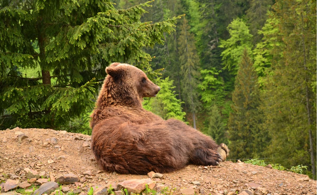
The Rehabilitation Centre for brown bears is located between the villages of Synevyr and Synevyrska Polyana (there is a sign near the road). Coordinates — N 48.557611 E 23.653139.
The museum Staroye Selo in Kolochava exhibits the diverse culture not only of the park but of the region as a whole. The village of Kolochava is an example of multiculturalism of the Transcarpathia region. Here you will see a holistic symbiosis of the cultures of the peoples living here, the Huzuls, the Boykas, the Lemkas, the Jews, the Romanians, the Slovaks, the Czechs, the Hungarians, the Germans, and the Ukrainians. Those ethnic groups form a unique mosaic of traditions, tastes and views. The museum exhibits the old houses of local residents and a variety of estates, ethnic clothes, elements of everyday life, agricultural tools and much more. The main attraction of the museum is that all exhibits presented here belonged to peasants. They lived in houses, worked on sewing machines, and studied at the old desks. So here you can see the real tea of the Verkhovinska life.
The Museum of Forestry and Timber Floating is the only one in Europe that acquaints you with the history of forestry, logging and transportation of timber by borash - men rafters who rafted huge logs via wild rivers of the Carpathians. The museum shows the tools of this ancient craft, models of knots, clothes of rafters, as well as insights into their everyday life. The museum is located near the village of Synevyr on the Black River which was once used to raft timber to Hungary.
Ivan Olbracht’s Museum is dedicated to the life and work of a Czech writer and director, journalist and publicist during his stay in Transcarpathia. The museum is widely known in the Czech Republic and Slovakia.
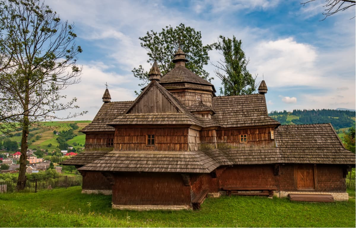
You can still see in the Carpathians wooden churches built without a single nail, those edifices usually belong to the Boyaks culture.
Located in the village of Synevyr, the Synevyr Visitor Centre introduces visitors to the Park, tells about the main objects, features, and routes. It provides necessary information about places to see and visit, the current situation on the routes. Therefore, it is worth starting your journey here.
The Office/Visitor Centre of the National Park:
Zakarpattya region
Mizhhirya district
Synevyr village
Phone.: +38 (03146) 2-76-18
+38 (03146) 2-76-90
Phone./fax: +38 (03146) 2-77-40
E-mail: npp-synevyr@rambler.ru
npp-synevyr.net.ua
Working hours: 9:00-18:00
The Synevyr National Nature Park offers the following organized routes.
Three basic one-day trails:
Eight longer routes:
On the territory of the park near the main routes, there are 5 authentic motel houses.
It is better to start a trip to the Synevyr National Park from the regional and district centres: Uzhgorod, Lviv, Ivano-Frankivsk, Khust, Mizhhorie, Volovets. You can take a shuttle bus to Synevyr, Kolochava, Olshan or Torunya. Most of these towns organize multi-day tours and excursions to the Carpathians, including the Synevyr National Park.
In case of travelling by public transport, it is worth noting that there is only one bus on this route from Khust, so it is better to go to Mizhhorie where buses run every one and a half hours in the direction of Synevyr and Kolochava. You can also get to Volovets by train and from there take a bus or hitchhike to your destination.
The most popular base camp for all trips in the Park is the village of Kolochava. The population of Kolochava is over 7 thousand people, and the length from one end of the village to the other is 15 km. You can often hear that Kolochava is a village of 10 museums and 20 monuments. Staying there you'll definitely have something to do in between the mountain hikes.


