Scan the QR code and open PeakVisor on your phone
Lam Tsuen Country Park is an expanse of green rugged ridges that’s located in the Hong Kong Special Administrative Region of China. The park has 8 named mountains, the highest and most prominent of which is Lo Tin Teng (585 m/ 1,919 ft).
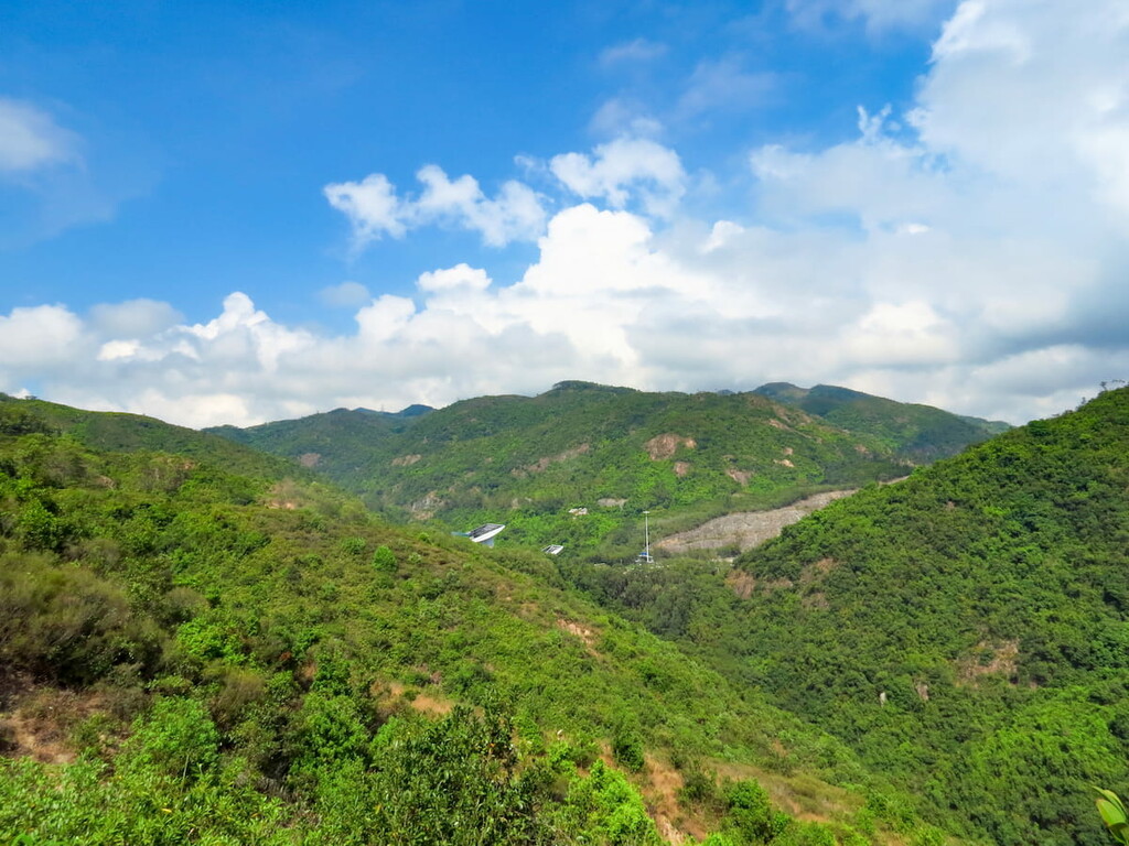
Occupying an area of 1,520 hectares (3,756 acres) in the northwestern New Territories of Hong Kong, the Lam Tsuen Country Park sprawls across the districts of Fanling, Tai Po and Yuen Long. It is dissected into two parts by Fan Kam Road, with the eastern part containing the ridge of Tai To Yan and the western part dominated by the ridge of Kai Kung Leng.
Tai To Yan trends in a northeast to southwest direction while Kai Kung Leng runs in a largely east to west direction. A network of streams on the hills flow down to Lam Tsuen River to the east, the Kam Tin River to the west, and the Sheung Yue River to the north.
Lam Tsuen Country Park is surrounded mostly by rural areas, including the villages at Kam Tin and Lam Tsuen. The southeastern side of the park is adjacent to the extensive Kadoorie Farm and Botanic Garden, while the northeastern corner borders on the urbanized area of Fanling, which is the most convenient gateway to the park.
Lam Tsuen Country Park is geologically classified as containing part of the Tai Mo Shan Formation, which includes the highest peak of the city, Tai Mo Shan. It is a volcanic formation that was created about 165 million years ago during the Middle Jurassic.
While the exact source of volcanic activity that created the Tai Mo Shan Formation is uncertain, one theory points to Pak Tai To Yan at the northeastern portion of the park, where an outcrop of tuff with a thicker volcanic sequence may have also arisen from an eruption.
The rocks in the park are mainly coarse ash crystal tuffs that are rich in volcanic glass and are mixed with some sandstones and metamorphic rocks. Their mostly homogeneous nature suggests that there were massive pyroclastic flows that accumulated quickly when these rocks formed.
The vegetation in the park is a mixture of woodlands, shrublands, and grasslands. Common trees include Taiwan acacia (Acacia confusa), Brisbane Box (Lophostemon confertus) and Chekiang machilus (Machilus chekiangensis).
The creeping psychotria (Psychotria serpens) is a vine that can often be seen on rocks and tree trunks in the park. Growing up to 6 m (20 ft) in height, it has fleshy leaves that store moisture and aerial roots that cling to the substrate.
Pak Tai To Yan in the park has been designated a Site of Special Scientific Interest, mainly because of a number of rare ferns found in its ravine, including Pronephrium triphyllum and Colysis wrightii.
That said, the slopes on Kai Kung Leng have suffered serious degradation in the past few years because of fires and cross-country motorcycling, the latter of which is prohibited in country parks. These motorbikes have left behind a crisscross of dusty tracks devoid of vegetation and top soil.
The park provides essential habitats for butterflies such as great orange tip, common mormon, peacock pansy, and red helen. It also shelters many bird species, including black kites, white-rumped munias, Chinese bulbuls, and crested bulbuls.
Wild mammals also roam the wilderness but are harder to spot. Some of the mammals found in the park that have conservation importance include the Chinese pangolin, Chinese ferret badger, and Chinese leopard cat.
Abundant fresh water and fertile soil in the area have supported human cultures for centuries. In fact, Lam Tsuen Country Park is named after the settlement of Lam Tsuen, which lies just beyond the eastern border of the park.
Lam Tsuen is a collection of 26 villages, the oldest of which is Chung Uk Tsuen. The name of the community means “the village of the Chung family,” and the community’s history dates back over 700 years. To this day, Chung is still the most common family name among Lam Tsuen’s villagers.
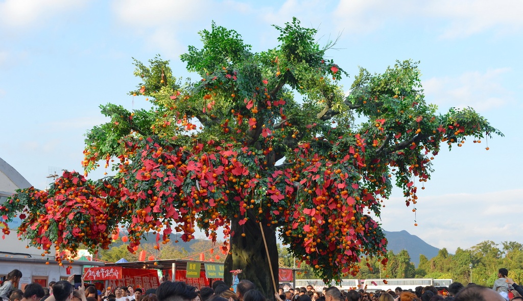
Lam Tsuen is most famous for its Wishing Trees, which are two banyan trees in Fong Ma Po Village that are reputed to have the magical power to make people’s wishes come true. Wishes are written on red joss paper, which is tied to an orange and then thrown up to the tree branches. It is said that the wishes will be granted if they can stay high up on the tree.
The ritual used to be practiced only by the villagers but is now popular among people from all over the city and even foreign tourists. Over the years, the accumulated wishes weighed down the trees so much that they were dying. Currently the banyan trees are protected for recovery, and wishes are thrown up to wooden racks and a fiberglass replica tree instead.
Under the southern foothills of the park is the basin of Kam Tin, which has also been inhabited for some 700 years. It is the ancestral home of the Tang clan, one of the Five Great Clans of New Territories.
Some of the villages in Kam Tin have or used to have defensive walls and watchtowers that protected them against pirates and bandits in the old times. The best known village is Kat Hing Wai, which has preserved its thick walls and the remains of a moat.
When the British took over New Territories from China in 1899, they encountered fierce resistance from the villagers of Kam Tin, and were not able to fight past the walls and moat until they used explosives. Some of the hundreds of villagers who died defending their home were buried in a communal martyrs' grave that’s located nearby.
Lam Tsuen Country Park is home to a number of excellent hikes. Here are some of the best trails to check out in the park during your next visit.
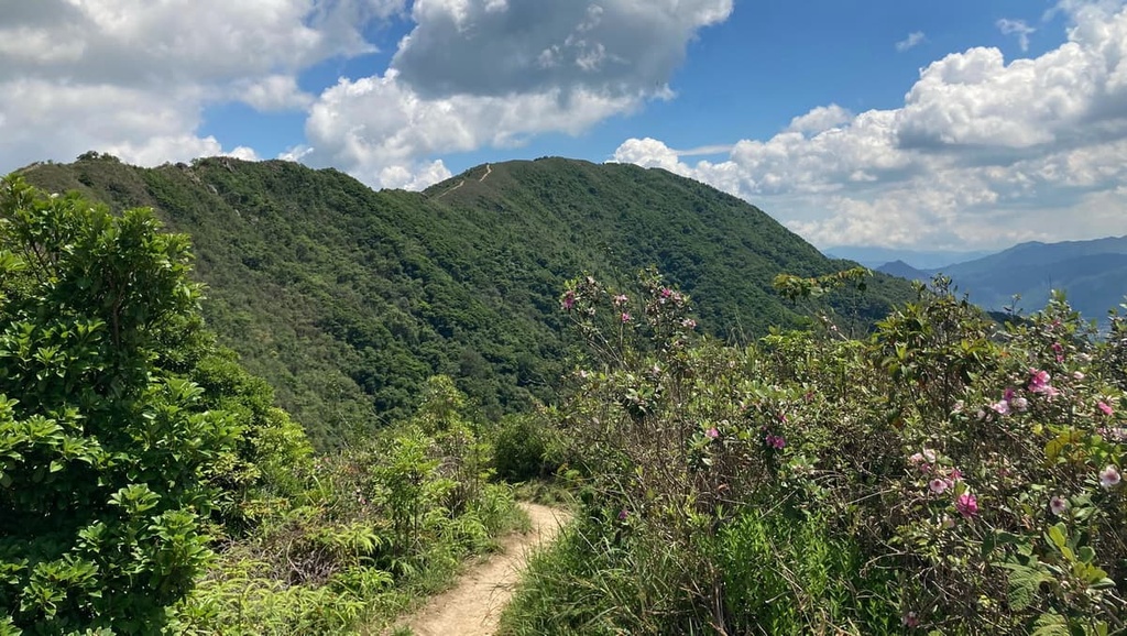
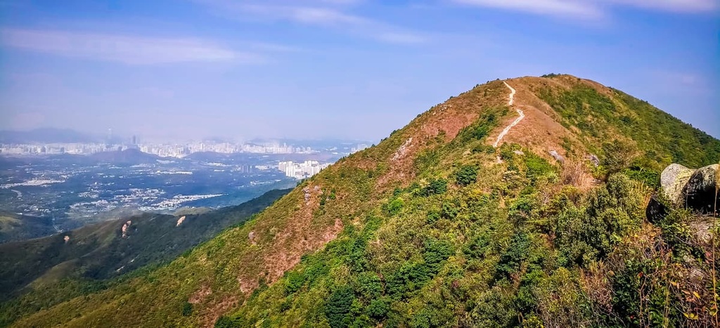
Also known as Razor’s Edge, the ridge of Tai To Yan has a sheer, chiseled profile that’s easily recognizable from a distance. It is a challenging 9.5-km (5.9-mi) hike between the Taoist temple of Fung Ying Seen Koon in Fanling and Kadoorie Farm & Botanic Garden in Tai Po.
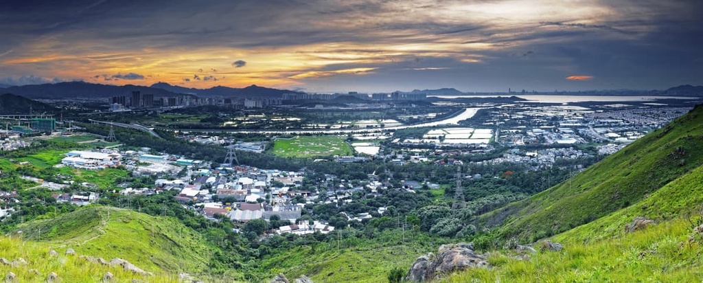
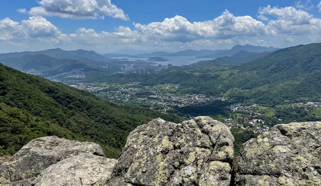
After a steep ascent, the trail becomes very narrow on the top with nearly vertical drops on both sides just like a razor’s edge. It commands panoramic views of the idyllic countryside of Kam Tin basin, Lam Tsuen valley, and Kai Kung Leng.
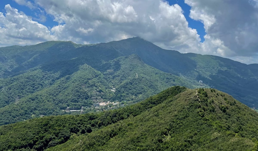
Compared to the more popular Tai To Yan, the trail to Kai Kung Leng is slightly higher with a softer profile, and it leads to three peaks on a ridge. It is for experienced hikers only as the trail is not only steep but also littered with loose gravel. Hikers should beware of mountain bikes and motorcycles that sometimes also come roaring down the path.
The ridge affords unimpeded views of the low-rise landscape and wetlands that are located close to the city’s border, the high-rise skyline of Shenzhen in Mainland China, as well as the bay in between.

The southern side of Tai To Yan is accessed from Tai Po, a district with a history that extends back at least one thousand years. Once an important market town, the urban area of Tai Po remains a vibrant community with busy streets. It is a popular base for outdoor activities because of its many nearby nature reserves and beautiful coves.
The northern side of Tai To Yan is located in Fanling, a traditionally rural area that’s home to a number of Indigenous communities. Today, historic villages and farms co-exist with modern apartment complexes. Sights include the imposing Taoist temple of Fung Ying Seen Koon, the walled village of Fanling Wai, and the Lung Yeuk Tau Heritage Trail.
Both ends of Kai Kung Leng lie in Yuen Long, which is also a major agricultural area as it contains the largest alluvial plain in Hong Kong. Despite rapid urbanization, you can still find sizable wetlands in Nam Sang Wai, oyster beds in Lau Fau Shan, and old villages with fish ponds and farms.