
Scan the QR code and open PeakVisor on your phone
iSimangaliso Wetland Park has 26 named peaks. The highest is Mpilo at 326 m. Other notable peaks include Bumbeni, Nxwala and Ntambama.
The iSimangaliso Wetland Park is one of Africa's most diverse ecosystems, with a wide range of marine, coastal, wetland, estuarine, and terrestrial environments. There are 26 named mountains in iSimangaliso Wetland Park; the highest and the most prominent is Mpilo, measuring 326 meters (1,070 ft).
The iSimangaliso Wetland Park is a World Heritage Site covering 328,000 ha (810,506 ac) along the eastern coast of South Africa in the Kwa-Zulu Natal province. The park spans 220 km (137 mi) of coastline, from the border of Mozambique in the north to Mapelane, south of the Lake St. Lucia estuary.
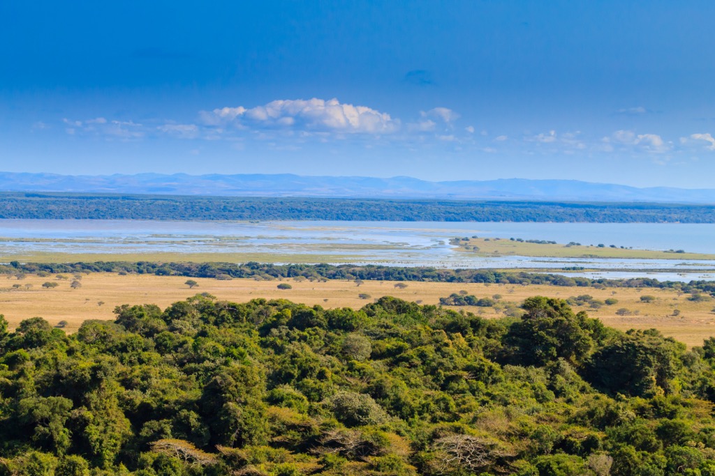
The park’s geography features a variety of landforms, such as coral reefs, long sandy beaches, coastal dunes, lake systems, swamps, and extensive reed and papyrus wetlands. The park also includes the Lebombo Mountains, which form a rocky ridge along the park's western boundary.
Among the lake systems within the iSimangaliso Wetland Park are the three major lakes of Lake St Lucia, Lake Sibhaiy, and Kosi Bay, as well as eight interlinking ecosystems. The largest and most famous is Lake St Lucia, the largest estuarine lake in Africa, covering an area of 32,500 ha (80,309 ac).
Due to its location between sub-tropical and tropical Africa combined with its coastal setting, the iSimangaliso Wetland Park boasts exceptional species diversity and ongoing speciation. The park serves as a critical habitat for a broad range of species originating from Africa's seas, wetlands, and savannahs.
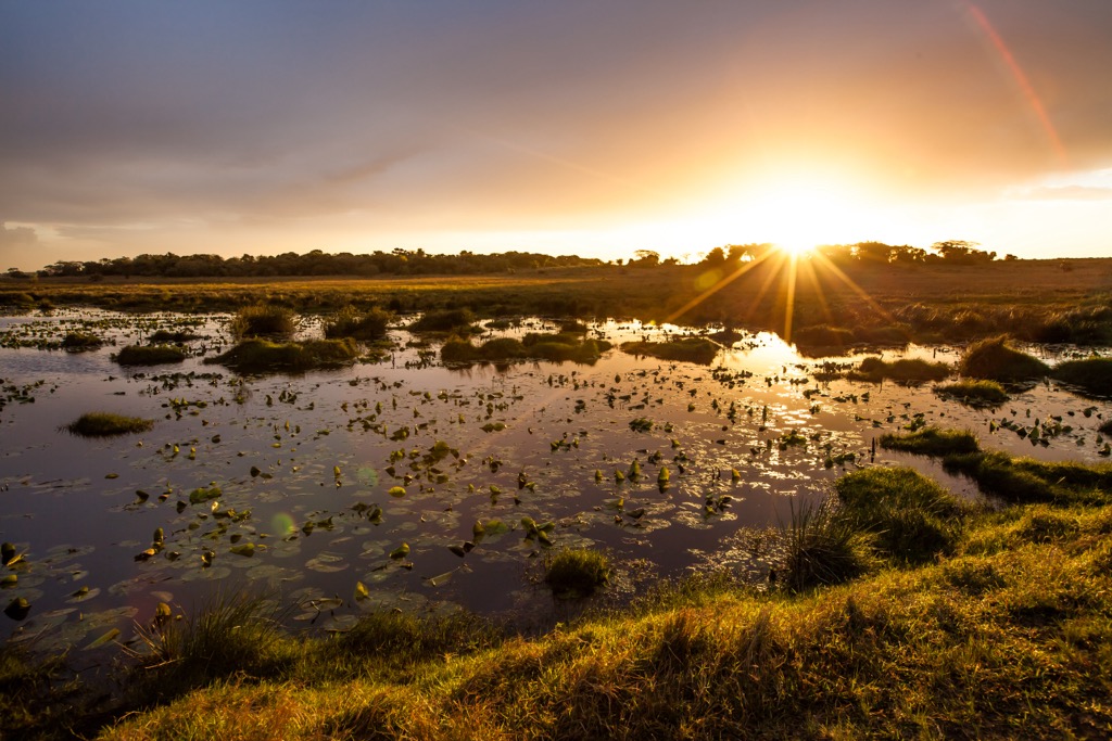
Several notable natural phenomena contribute to the park's significance, including Lake St. Lucia's dynamic salinity states, turtles' nesting activities, and the migration of whales and whale sharks along the coastal areas. The wetlands also host large populations of waterfowl, along with breeding colonies of pelicans, storks, herons, and terns.
The park has a long geological history dates back to the early Pleistocene. The coral reefs are among the most diverse in the world and are formed by the growth of coral polyps on the continental shelf, which the warm Agulhas Current influences.
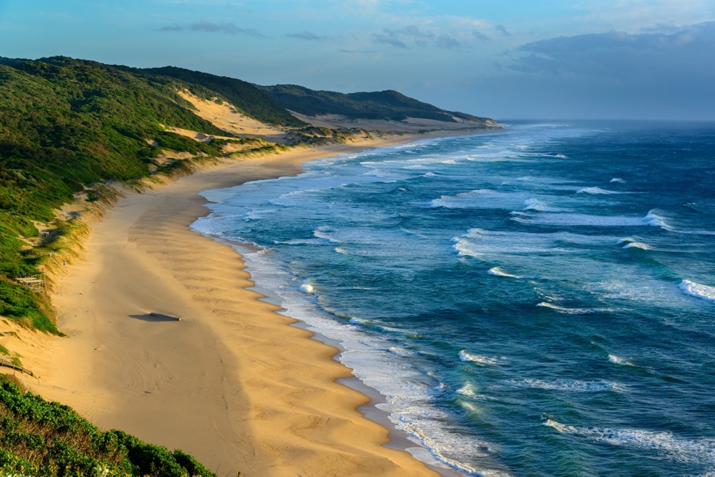
Along the coastal land, long sandy beaches result from the accumulation of sand transported by waves and currents from the continental shelf and the erosion of the coastal dunes. The coastal dunes are the highest vegetated dunes in the world, reaching up to 180 meters (590 ft).
The swamps and wetlands are the most extensive in South Africa, covering about 80,000 ha (197,684 ac). They are a product of accumulated organic matter in low-lying areas flooded by water from rivers, lakes, and rainfall. The swamps and wetlands provide critical ecological functions, such as water purification, flood control, and carbon sequestration.
Within iSimangaliso Wetland Park's boundaries thrive an extensive array of over 2,000 plant species, many of which are endemic or threatened. Notable amongst these diverse plant groups are mangroves that grow in saline coastal habitats, such as estuaries and lagoons.
The soil also nurtures the growth of the endemic Maputaland cycad, an ancient plant that resembles a palm tree but is more closely related to conifers as they produce cones. Various trees further enrich the park's canopy, some rare or exclusive, such as the dune sweet thorn, white milkwood, coast strelitzia, coast red milkwood, and Cape ash.
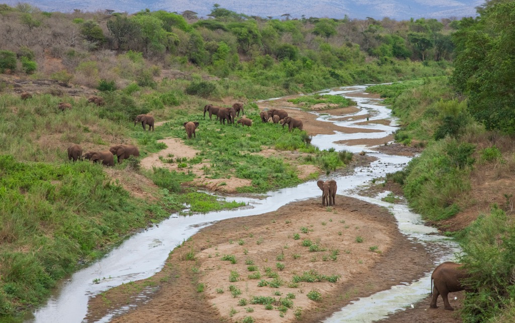
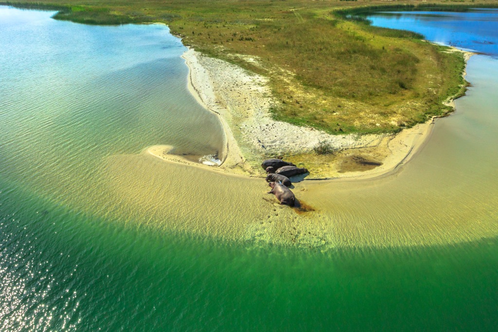
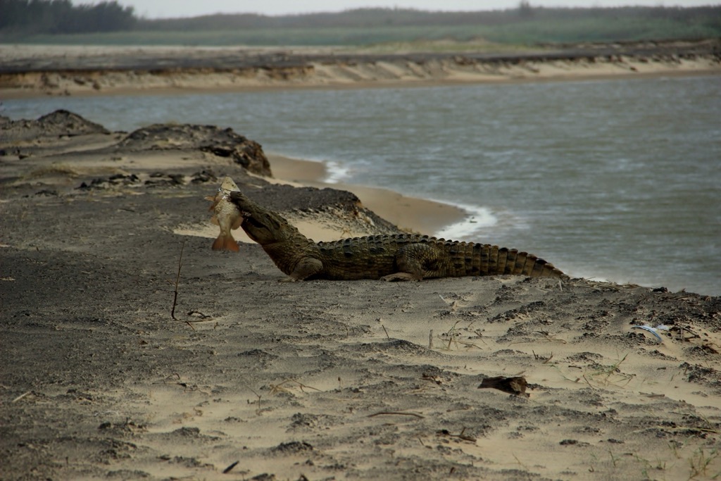
Some of the most iconic animals of the park are hippopotamuses and Nile crocodiles, which inhabit Lake St Lucia. The park also hosts the largest population of leatherback and loggerhead turtles in Africa, which nest on the sandy beaches between October and February. The park's coral reefs are rich in marine life, including tropical fish, sharks, dolphins, humpback whales, and southern right whales.
iSimangaliso Wetland Park also boasts a high diversity of mammals, such as elephants, rhinos, buffalos, giraffes, leopards, and various antelopes. In addition, the park is also a birdwatcher's paradise, with over 530 species of birds, including flamingos, pelicans, eagles, storks, cranes, and kingfishers.
The human history of iSimangaliso Wetland Park dates back to the later Stone Age when people used decorative pierced seashells found in Border Cave in the Lebombo Mountains. More recently, Iron Age sites at Enkwazini, east of Lake St Lucia, date back to 290 AD.
The first Bantu peoples arrived around 1440 and influenced the landscape through livestock grazing, hunting, and bush clearance. The area was also visited by Arab traders, European explorers, hunters, ivory traders, and missionaries over the centuries.
The first conservation efforts in the area began in 1895 when the Hluhluwe-iMfolozi region was established as the oldest conservation area in South Africa. The park was declared a World Heritage Site in 1999 and was renamed iSimangaliso Wetland Park in 2007. The park’s management aims to protect the area's natural and cultural heritage while promoting community development and tourism.
The Ingwe Trail is a 6.8 km (4.2 mi) loop tracing the course of the Mfolozi River, from where hikers observe crocodiles, hippos, and various waterbirds in their natural habitat. As the trail progresses, it ascends to a ridge that affords panoramic views of the Indian Ocean, coastal forest, surrounding wetlands, and the coastal hills of Mjakaja, Sokhulu, and Red Hill.
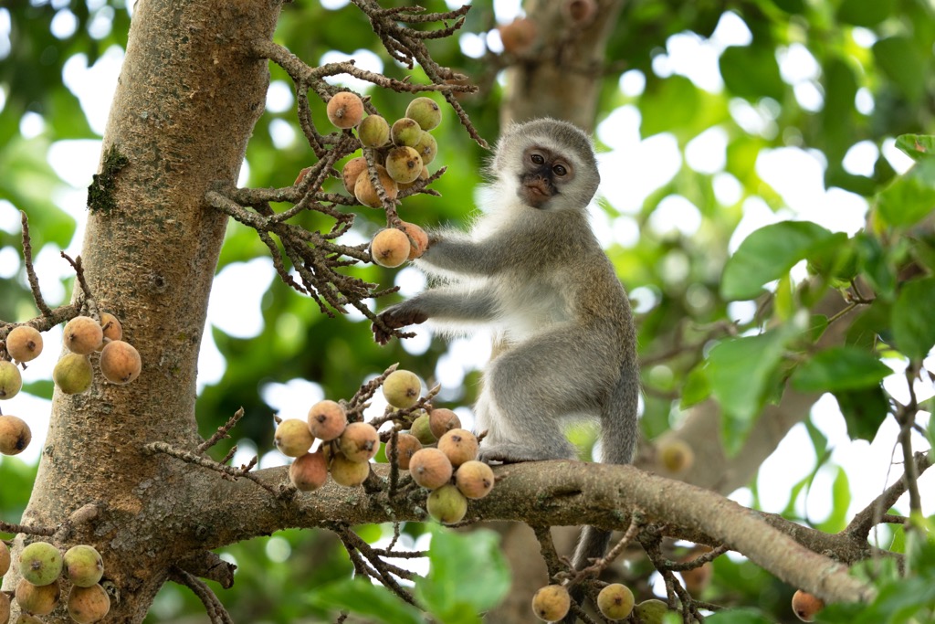
En route, hikers may encounter a variety of wildlife, including antelopes, monkeys, and other species. Optimal conditions for tackling the Ingwe Trail are during the dry season, from May to October, when temperatures are milder and the vegetation is less dense.
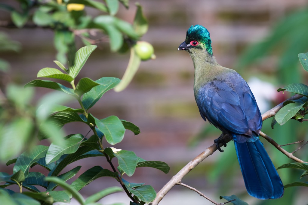
The Gwalagwala Trail is a 2.3 km (1.4 mi) route suitable for birdwatchers and nature enthusiasts. The Zulu name for the trail, iGwalagwala, translates to 'the place of the Purple-crested Turaco,' a colorful bird often seen along the trail. Hikers may also encounter other birdlife, such as the White-eared Barbet, the Red-capped Robin-chat, and the Southern Boubou.
Commencing at the southern end of St. Lucia, the trail meanders through the coastal forest, offering hikers glimpses of wildlife, such as vervet monkeys, tree squirrels, and bushbuck. The trail concludes at the edge of the St. Lucia Estuary, a habitat for crocodiles and hippos.
The iNgwe Beach Walk is a linear trail that guides hikers from the coastal forest to the sandy shoreline. It spans a distance of 3.5 km (2.2 mi) long and has an elevation gain of 16 meters (52 ft).
The trail commences at the parking area near the Dukuduku gate, progressing along a dirt road within the forest. Along this route, hikers may encounter monkeys and diverse bird species. The trail eventually leads to a wooden boardwalk that spans a small stream, guiding hikers toward the beach. The coast offers views of the Indian Ocean, the dunes, and the estuary mouth, home to seabirds and dolphins.
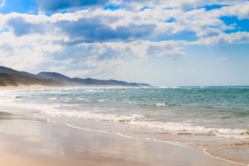
The Main Beach Walk is a coastal walk, starting from the parking lot near the beach. The path follows the shore for about 15 km (9.3 mi), offering views of the Indian Ocean and coastal dunes. Hikers may encounter birds, crabs, turtles, and even whales and dolphins throughout the journey. The trail is suitable for walking, running, or cycling, but be prepared for soft sand and strong coastal winds.
Richards Bay is a coastal town in the KwaZulu-Natal province of South Africa. It is situated on the country's northeastern coast and is a significant industrial port. The town itself is quite industrial, but the surrounding region has plenty of activities.
Alkantstrand is a popular beach in Richards Bay that is great for swimming, sunbathing, and beach walks. The Indian Ocean’s warm waters make it an ideal spot for water activities.
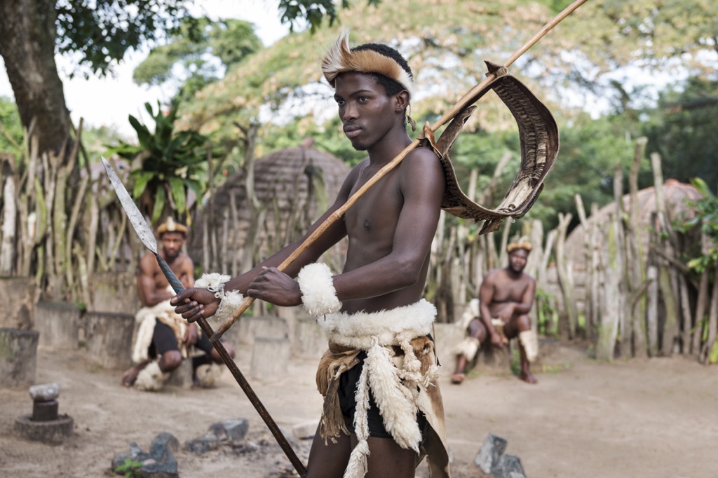
DumaZulu Cultural Village is a living museum that showcases the traditional culture and lifestyle of the Zulu people. Visitors can watch Zulu dancers, visit the craft market, taste the local cuisine, and learn about the history and customs of the Zulu nation.
Hluhluwe-iMfolozi Park is the oldest proclaimed nature reserve in Africa and home to the Big Five, such as the lion, leopard, rhino, elephant, buffalo, and many other wildlife species. Visitors can go on a safari tour and see the animals in their natural habitat.
St. Lucia is a small town north of Richards Bay, located within the iSimangaliso Wetland Park. St. Lucia is a popular tourist destination for its rich biodiversity, scenic beauty, and diverse activities.
St. Lucia Estuary offers boat tours, where visitors can observe hundreds of hippos, crocodiles, and birds and learn about the area's history and ecology from guides.
The protected bay of Cape Vidal encompasses an underwater world where snorkelers can encounter colorful fish, coral, turtles, dolphins, and whales. The best time to snorkel is during low tide when the water is calm and clear.
Finally, visitors can discover the ancient history of the Lebombo Mountains, which bear rock paintings and display stone tools and human remains dating back to 130,000 years ago. The mountains also offer spectacular views of the landscape and the lake.


The highest peak in iSimangaliso Wetland Park is Mpilo, at 326 m.
Notable peaks in iSimangaliso Wetland Park include Mpilo, Bumbeni, Nxwala, Ntambama and Nyathikazi.


