
Scan the QR code and open PeakVisor on your phone
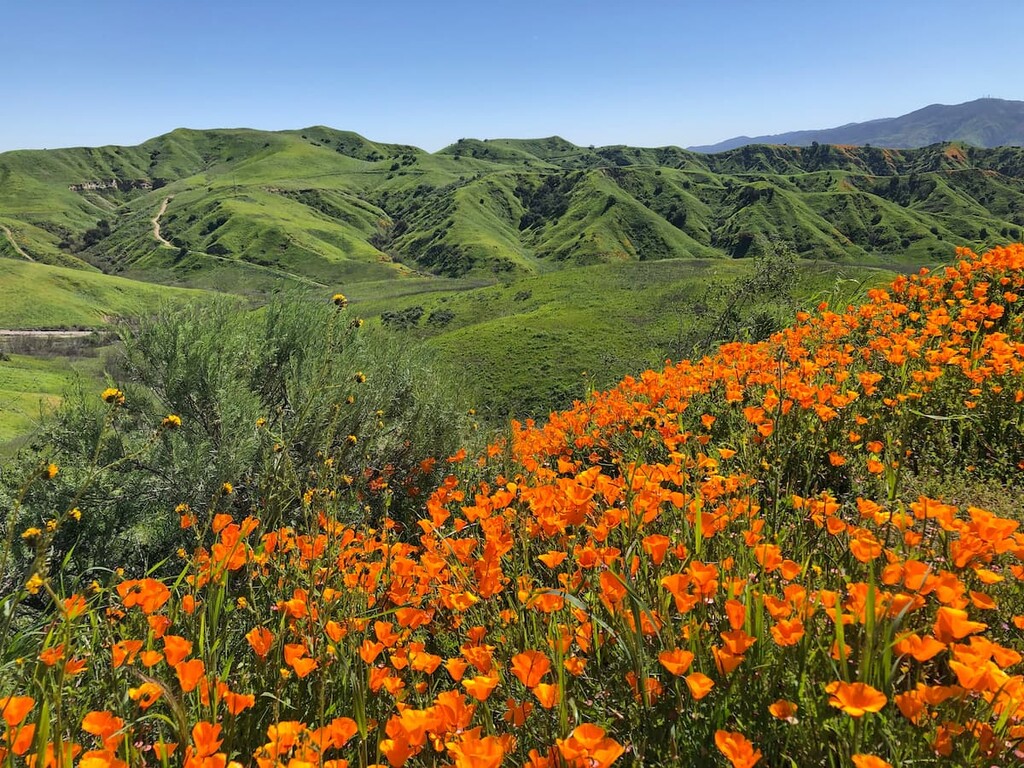
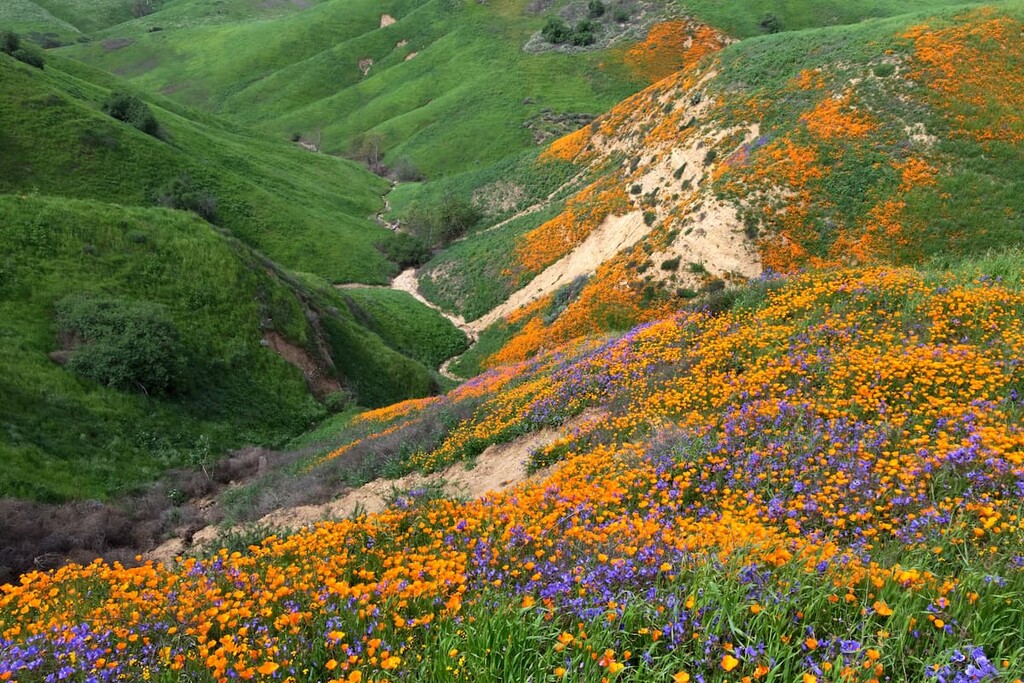
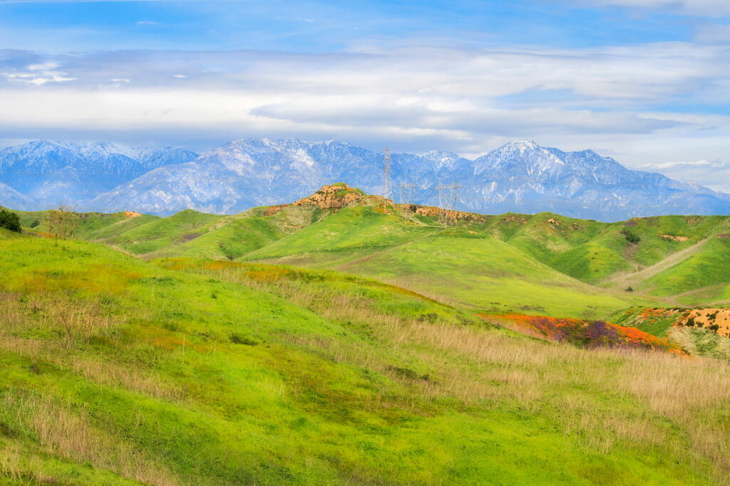
Chino Hills State Park is surrounded by the suburban communities of Corona, Chino Hills, Yorba Linda, and Brea and is about 45 minutes to an hour away from Los Angeles. This hilly open-space recreational area is a calm juxtaposition to many of he surrounding state parks and national forests, which often attract visitors for their foliage or rock formation. Chino Hills State Park, however, draws in visitors for its wide expansive views of the regional San Gabriel and Santa Ana Mountain ranges and Angeles National Forest, as well as its wildflower blooms in the spring. Ranging from 400 to 1,781 feet in elevation, the park sits between the north end of the Santa Ana Mountains and the southeast portion of the Puente-Chino Hills.
Chino Hills State Park has more than 14,000 acres of rolling, grassy hills and valleys, dotted with stands of oaks and sycamores. The park also has around 90 miles of trails that offer excellent opportunities for viewing wildlife and native plants. Given its size, this park is perfect for trail runners and mountain bikers. There is also camping and equestrian stables for horse riding on some of the trails.
The State Routes 57, 71, 91, and 142 border or are the near the park for easy travelling and accessibility from almost anywhere in Southern California. Entry into the park can either be done on foot at no cost, with ample parking on the outskirts of the park, or visitors can pay $5 per vehicle entry.
There are more than 200 species of birds and mammals, numerous reptiles and amphibians, and thousands of kinds of insects and other invertebrates living in the park, such as; Bell’s vireo, the California gnatcatcher, and the coastal cactus wren, which are considered rare, threatened, or endangered. The diversity of native plants and animals found in this region is ranked one of the highest in the United States.
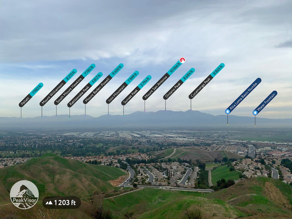
From the park you will see a variety of mountain peaks and landmarks including; Strawberry Peak (6155 ft) Heaps Peak (6414 ft), Butler Peak (8517 ft), Harrison Mountain (4738 ft), Sugarloaf Mountain (9938 ft), Anderson Peak (10,873 ft), San Gorgonio Mountain (11, 490 ft), Snow Peak (7923 ft), Kitching Peak (6575 ft), Mount Edna (4341 ft), San Jacinto Peak (10,827 ft), Palm View Peak (7165 ft), Pallett (7982 ft), Mount Williamson (8215 ft), South Mount Hawkins (7785 ft), Rattlesnake Peak (5817 ft), Mount Baden-Powell (9400 ft), Iron Mountain (7999 ft), Sunset Peak (5794 ft), Mount San Antonio (10,066 ft), Ontario Peak (8684 ft), Cucamonga Peak (8865 ft), Alta Loma Basin, Little Cahuilla Mountain (5039 ft), Gavilan Peak (2339 ft), Monument Peak (2339 ft), Estelle Mountain (2766 ft), Agua Tibia Mountain (4777 ft), Trabuco Peak (4616 ft), Santiago Peak (5696 ft), Pleasants Peak (4012 ft), Sierra Peak (3051 ft), Bald Peak (3940 ft), Palm View Peak (7165 ft), and Thomas Mountain (6814 ft), among others.
The Chino Hills State Park area was originally home to the Tongva (Gabrielino) Indians, who lived along the Santa Ana River basin, and set up temporary camps here for gathering food. After the Spanish founded Mission San Gabriel in 1771, the Chino Hills were used extensively as grazing land for cattle, which continued through the Mexican Republic era, and past 1848 after Mexico ceded California to the United States. In the 1870s to the 1890s private land acquisition began. There was also oil exploration and mining activity in the area in the late 19th and early 20th centuries. In 1948 the 1,720-acre Rolling M Ranch was established, and the land was leased to nearby landowners for cattle grazing. A ranch house, historic barn, and several windmills and watering troughs still exist in the park and serve as reminders of the area’s cattle ranching days.
In 1977 the California Legislature passed a resolution directing California State Parks to conduct a study on acquiring Chino Hills land for park purposes and initially acquired 2,237 acres. In 1984, the California Legislature officially designated the space a state park and the land area grew to the approximately 14,000 acres it is now.
Chino Hills State Park is home to two types of rattlesnakes; the Southern Pacific Rattlesnake (Crotalus helleri) and the Red Diamond Rattlesnake (Crotalus ruber). The Southern Pacfiic Rattlesnake has a pale brown, gray-brown, or yellowish brown ground color overlaid with a series of large, dark brown dorsal diamond shaped blotches that may or may not have pale centers. The Red Diamond Rattlesnake is a moderately large pit viper with a similar pattern to the Southern Pacific Rattlesnake, but that is reddish in color.
These more often shy and misunderstood creatures rarely bite or bother humans and prefer to be left alone. In fact, if you run into one in the park they are likely heading away from you as they can feel hikers coming due to the vibration of the ground. Additionally, Chino Hills State Park has very little ground cover so it is much easier to spot a snake before you get too close. If you see a poisonous snake, leave it alone until it passes off the trail. If the snake does not seem to be leaving a pathway, contact a local ranger.
Chino Hills State Park is a pick your own adventure location when it comes to hiking, trail running, horseback riding, or mountain biking. Due to its mostly treeless wide expanses it is immensely easy to see where you are going and keep your bearings. Many hikers can go into the state park without much of a plan and feel confident that they can make their way back to their car without any issue at all. However, there are a number of named trails to consider when planning your trip.
Some of the named trails in the park include; the Butterfield Trail, Community Park Trail, Fairfield Ranch Trail, Grand Avenue Park Trail, Hickory Creek Trail, La Sierra Trail, Madrugada Trail, McCoy Trail, Oakridge Trail, Overlook Trail, Ridgeview Trail, Sunset Trail, Torrey Pines Trail, Veterans Park Trail, Vellano Trail, and the Vila Borba Trail.
Chino Hills State Park has recently started a number of trail enhancement projects to address damaged signage, as well as damage and increased erosion due to burn recess. Like much of southern California, Chino Hills State park has been affected by the increase in wildfires in recent years, which has become apparent when you see the burn state of many of the state park’s trees in the valleys and along the steep hills. It should be noted that due to the steepness of the Chino Hills, the state park is closed immediately following moderate or heavy rains.


