
Scan the QR code and open PeakVisor on your phone
Anhui is home to 1,673 named mountains. The highest is Lotus Peak at 1,864 m.
Anhui (安徽, Ānhuī ) is a mountainous, landlocked province in eastern China that’s home to 1673 named peaks. The highest and most prominent mountain in the province is Lotus Peak (莲花峰, Liánhuā fēng), one of China’s most famous and beautiful mountains.
While Anhui is one of China’s smallest provinces by area, it covers diverse landscapes including wide plains, sprawling lakes, and high mountain peaks. The province is home to over 60 million people.
The highest point in Anhui is Lotus Peak at 1,864 m (6,115 ft). The mountain and its surrounding area are more commonly referred to collectively as Huangshan (黄山, Huángshān), which translates to Yellow Mountain. Huangshan has been famous throughout Chinese history as a subject of art and poetry, and it’s one of the most popular tourist attractions in the country today.
Outside of the mountainous areas in the southern part of the province, Anhui is dominated by lakes, wide plains, and the Yangtze River 长江 (Cháng Jiāng), which divides the province into northern and southern halves. The Huai River (淮河, Huái Hé) crosses the plains in the northern half of the province.

Most of Anhui’s major cities are located on the Yangtze River, with the exception of the capital Hefei (合肥, Héféi), which lies on the plains in the center of the province. Anhui is bordered by six provinces: Jiangsu (江苏, Jiāngsū) to the east, Zhejiang (浙江, Zhèjiāng) and, Jiangxi (江西, Jiāngxī) to the south, Hubei (湖北, Húběi) to the west, and Henan (河南, Hénán) and Shandong (山东, Shāndōng) to the north.
Anhui is known for its food. In fact, Anhui cuisine (often called Huīcài, 徽菜) is one of the eight great culinary traditions of China. Anhui chefs are known to frequently use wild plants and herbs and to cook with lots of oil.
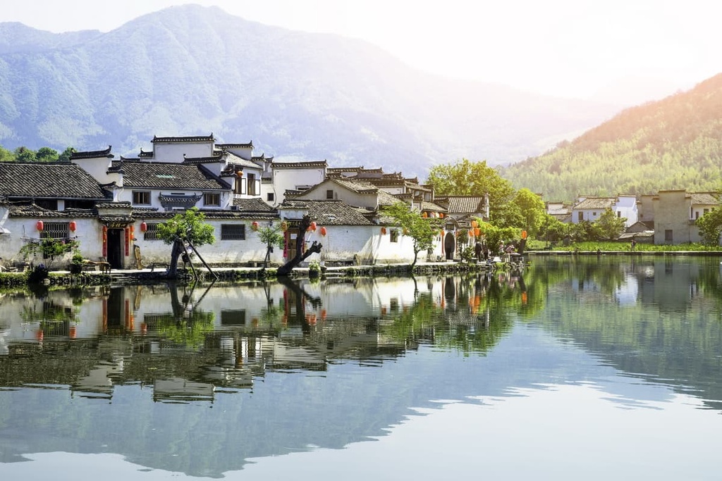
The province is also known for Huizhou architecture, which is considered one of the most important schools of traditional Chinese architecture. Villages with well-preserved Huizhou buildings have become major tourist attractions.
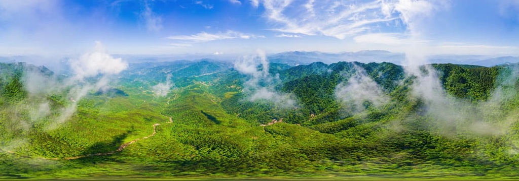
While most of the northern area of Anhui consists of wide plains, there are two major mountain ranges in the southern part of the province.
The Dabie Mountains (大别山, Dàbié Shān) run southwest to northeast from Anhui into Henan and Hubei, forming part of the border between southwestern Anhui and Hubei.
The tallest mountain in the range is Tianzhu Shan (天柱山, Tiānzhù Shān), which was called Mount Wan (皖山, Wǎn Shān) in ancient China. The mountain became associated with the province and the character “Wan” is still used as the abbreviation today (on license plates and road signs, for example) for the province of Anhui.
The Dabie Mountains form the main dividing watershed between the Huai River in the northern half of Anhui and the Yangtze in the southern half. They’re a heavily forested range featuring extensive bamboo and cork oak stores.
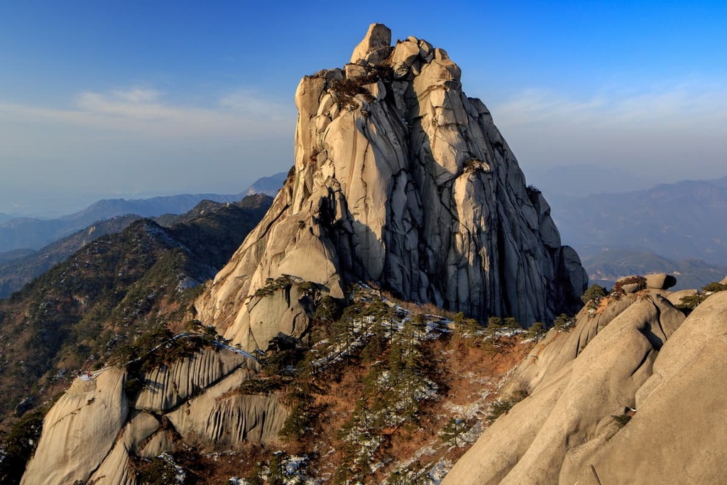
The highest mountains in Anhui lie in the Baiji Range, which occupies the southern and eastern corners of the province, along the border with Zhejiang. The range is home to Huangshan, the most famous mountain in Anhui.
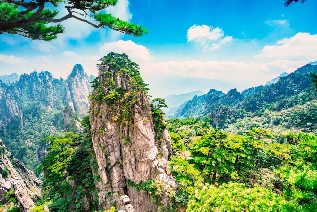
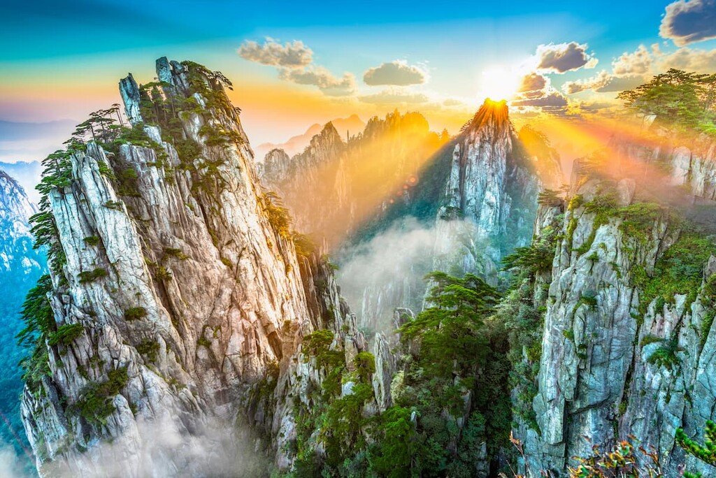
The Baiji Mountains are known for their Mesozoic granite formations, which are best seen in the towering granite spires at Huangshan. Some of these granite spires are over 1,000 m (3,280 ft) tall.
As is the case with its geology and topography, Anhui features different ecology in the northern plains and mountainous southern areas of the province.
The northern plains of the province have been heavily deforested by agricultural and industrial activities, resulting in soil erosion. Since the 1950’s, efforts have been underway to restore the large bamboo forests that used to cover the province.
The mountainous areas of southern and eastern Anhui still preserve some of the original bamboo forests. In the area around Huangshan, which is preserved as a UNESCO Geopark, there are over 1,400 endemic species of plants.
One of the most notable animals in the province is the endangered Yangtze alligator (historically called “the muddy dragon”). It’s the only species of alligator native to China, and it’s only found in Anhui.
While the province of Anhui has existed for less than 500 years (making it fairly new, in terms of Chinese history), people have been living in the area for thousands of years.
The oldest evidence of human settlement in Anhui goes back 20,000 years, and there are more extensive neolithic Yangshao and Longshan archaeological sites in the province that date back up to 10,000 years.
From the time of China’s first imperial unification in 221 BC through most of the next 2,000 years, Anhui was considered part of its neighboring provinces or broken up into separate counties. In 1667, during the Qing dynasty, Anhui was separated from the neighboring Jiangsu province and created as its own entity.
The name “Anhui” comes from combining the names of the cities Anqing and Huizhou, which were the major population centers when the province was established.
While the premier hiking destination in Anhui is undoubtedly Huangshan, it’s not the only sacred, historical mountain in Anhui.
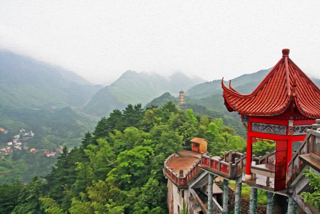
Jiuhua Shan (九华山, Jǐuhuà Shān), along with Wutai Shan in Shanxi, Emei Shan in Sichuan, and Putuo Shan in Zhejiang, is one of the four great Buddhist mountains of China. It’s been a center of Buddhism for over 1,000 years. During the Ming and Qing dynasties, there were over 300 temples and several thousand monks and nuns living on the mountain.
Today, Jiuhua Shan is famous as a tourist attraction. In addition to beautiful scenery and numerous historic temples, the mountain features a massive, 99 m (325 ft) tall gold statue of the Buddha.
Jiuhua Shan isn’t just one mountain but a series of over a hundred peaks. There are numerous hiking trails, temples and summits that could keep you occupied for several days. The mountain park is located southeast of Chizhou city (池州, Chízhōu), about 150 km (95 mi) north of Huangshan, so it’s easy to visit both mountains.
Tianzhu Shan (天柱山, Tiānzhù Shān) is another Anhui peak that’s been well-known throughout Chinese history. It was originally called Mount Wan ( 皖山, Wǎn Shān), which became the modern abbreviation for Anhui province.
While the landscape isn’t as dramatic as Huangshan, Tianzhu Shan has some of the same granite spire formations as the more famous mountain. It has a total of 45 peaks over 1,000 m (3,280 ft), the highest of which tops out at 1,760 m (5,774 ft).
Tianzhu Shan is also famous for its waterfalls and temples. It’s even home to a valley that contains over 50 caves.
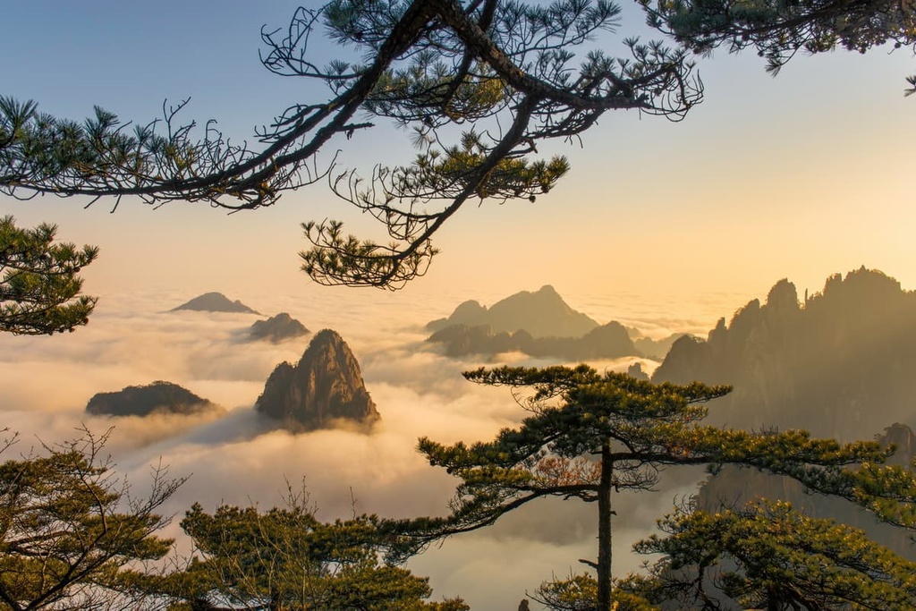
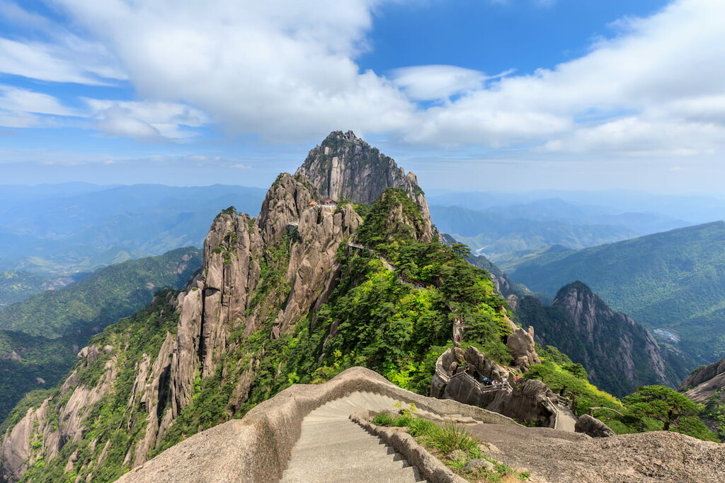
Huangshan is a UNESCO Global Geopark and a near-mythical location throughout Chinese history. The mountain was officially named by royal decree in 747 CE, and it’s been a frequent subject of painting, poetry, and folk legends ever since.
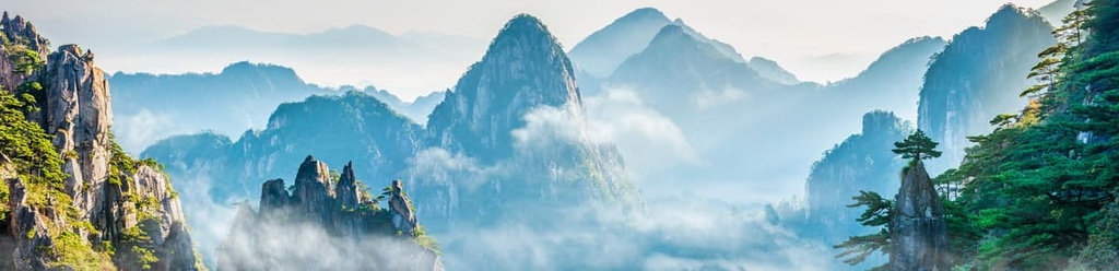
The park as a whole contains dozens of individual peaks, 77 of which reach over 1,000 m (3,280 ft). The area is known for its frequent inversions, where the peaks reach above the clouds, and for its ancient pine trees that grow out of the near-vertical rock walls.
Huangshan is a developed mountain park, so there are cable cars, hotels, restaurants, and stone stairs as opposed to dirt paths. Most people opt to spend at least one night in one of the hotels on the mountain in order to catch Huangshan’s famous sunrise and sunset. If you want to see the “sea of clouds,” where the peaks rise above the cloud cover, you have the best chance of catching it during the winter months.
If you do want to hike the whole mountain, climbing the eastern steps will take about three and half hours, while the western steps take around seven hours. Be aware that even if you do take the cable cars, there’s no way to see Anhui without stairs and climbing. Once you’re on the ridge, nearly everything is up and down.
Also note that the hot springs at the base of the mountain are a great place to relax after a long day of hiking.
In addition to bustling cities, Anhui has a number of beautiful small towns and villages that are well worth a visit.
Located just outside Huangshan, Hongcun (宏村, Hóngcūn) is a well-preserved (albeit touristy) traditional village featuring beautiful Huizhou architecture. It’s often visited together with neighboring Xidi, a smaller but similarly well-preserved village.
Most people visit for a few hours before heading on to Huangshan, but you can spend the night in one of the village’s small inns if you want to see a quieter side of Hongcun. The area is known for its “sea of flowers” in the spring and bright foliage in the fall.
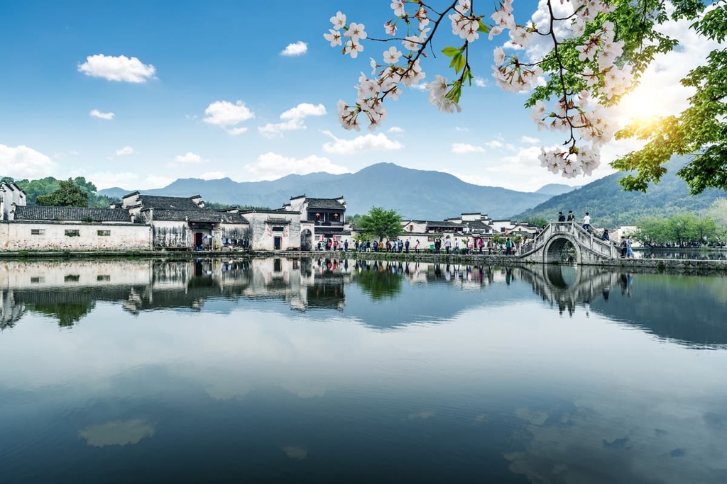
If you’re interested in learning more about Chinese life, or if you just want to see China outside its major cities, Hongcun is a great place to stop.
If you’re visiting the peak of Huangshan, you’ll almost certainly have to transit through Huangshan city. While it might not be much of a destination in itself, Huangshan has a reconstructed “old town” that makes for a nice stroll (especially if you couldn’t make it to Hongcun).
Beyond the Tunxi Old Street, Huangshan is a great place to sample Anhui cuisine without the tourist hotspot markup. It’s also a great place to buy the famous Huangshan Maofeng green tea.
Hefei (合肥, Héféi) is Anhui’s capital and largest city, with nearly 8 million inhabitants in the broader metro area. It has a number of universities and laboratories, and it is considered a center of scientific research within China.
While Hefei isn’t usually on foreign tourists’ radar, it does have a few attractions, including a botanical garden, a rebuilt “historic town,” and several beautiful municipal parks. The main attraction is Chao Lake (巢湖, Cháohú), one of the largest freshwater lakes in China, which is located just southeast of the city center.


Yes. Anhui has 1,673 named mountains. The highest is Lotus Peak at 1,864 m.
The highest mountain in Anhui is Lotus Peak, at 1,864 m.
Anhui has 1,673 named mountains.


