Share

Scan the QR code and open PeakVisor on your phone
Scan the QR code and open PeakVisor on your phone
There are 85 named mountains in Mosquito Range. The highest and the most prominent mountain is Mount Lincoln.
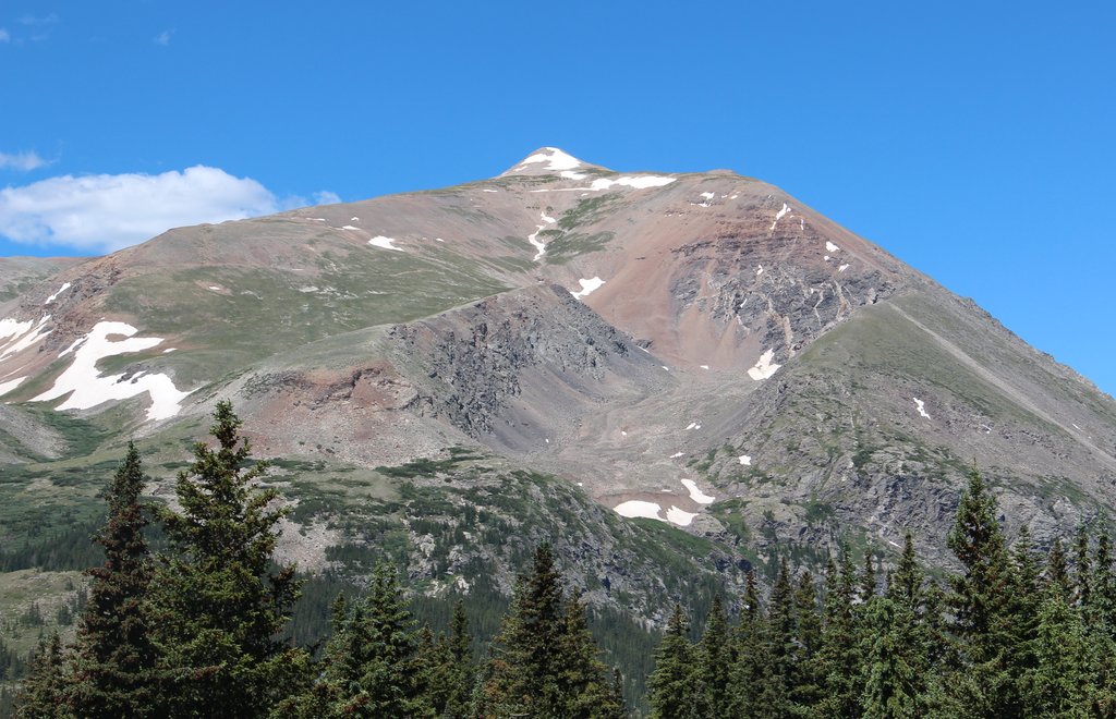
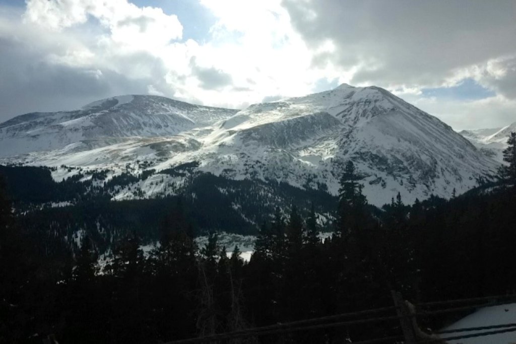
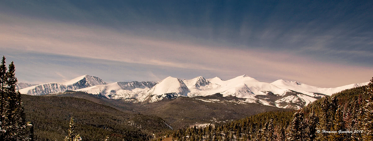
The Mosquito Range is a sub-range of the Rocky Mountains and is located in central Colorado. It extends approximately 50 miles from Buena Vista in the south to Frisco, on the shore of Dillon Reservoir, in the north. From the west end at Leadville, it extends only about 15 miles to the east at the town of Fairplay. The north one-third of the range lies in Pacific watershed while the southern portion is on the Atlantic side of the Continental Divide, which crosses the range from Hoosier Pass on the east to Fremont Pass on the west. It is home to six mountains over 14,000 feet in elevation of which one, Mt. Cameron, is not an official fourteener since its prominence does not qualify its inclusion.
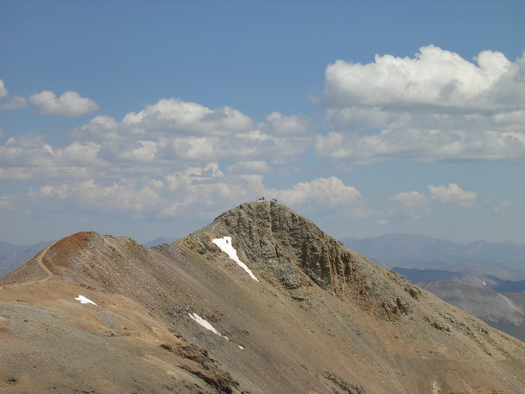
The five official fourteeners are Mount Lincoln, the highest in the range, Mount Bross, Mount Democrat, Mount Sherman and Quandary Peak. The connecting ridge between Bross and Lincoln crosses over Cameron which is therefore usually traversed when these peaks are climbed. All of these peaks are relatively easy and can be negotiated by any hiker in reasonably fit condition. But they are high such that acclimatization to the altitude is a necessary prerequisite for anyone attempting to climb them. There are also several high thirteeners, that may in fact present more challenge to climbers than do the fourteeners, which are more popular and more commonly climbed. Climbing access to these mountains is generally easier from the east side since there are a number of forest roads that can be reached from State Highway 9.
The Mosquito Range also encompasses a minor sub-range known as the Tenmile Range. Beginning at Frisco in the north, the first ten peaks are numbered Peak 1 through Peak 10 at the Breckenridge ski area, with the higher peaks at the south end. Peak 4 is alternatively known as Tenmile Peak. The traverse of these peaks from Frisco to Breckenridge would be a challenging undertaking involving some Class 3 and Class 4 technical segments and should only be attempted by seasoned hikers. The total trail distance from town to town is 19 miles and involves over 7,000 feet of total ascent. Continuing south from Breckenridge, the Tenmile Range ends at Quandary Peak, its highest point. The straight-line distance from the summit of Peak 1 to the summit of Quandary Peak is almost exactly ten miles - hence the name of the range presumably.
The major access points for hiking in the Mosquito Range are along the east side of the range, all of them from State Highway 9. While there are access points from the west side of the range, the most popular hiking areas can best be reached from the stretch of Highway 9 between Breckenridge in the north and Fairplay in the south. But there are some access points and trails on the west that should not be ignored.
When driving west on Interstate 70 from Frisco toward Copper Mountain at Wheeler Junction - the highway actually heads south in this stretch - the western slopes of the Tenmile Range look very imposing and intimidating. One would not want to try to access this range here - nor would one want to bail from the ridge here in bad weather. So that leaves the east side as the only viable access to this range. However, once one reaches Wheeler Junction and leaves I-70 to continue south on State Highway 91 toward Leadville, there are limited access points into the Mosquito Range.
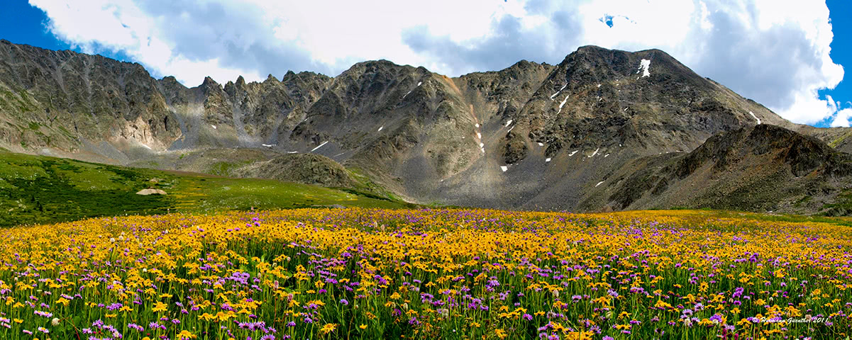
Mayflower Gulch - This is a scenic and popular trail that penetrates the Mosquito Range, and can be used to stage an assault on some high thirteeners, though that is not advisable for casual hikers. The real attraction here is an easy high-country hike (beginning at around 11,000 feet) to an old mining area that sits at the very base of Fletcher Mountain (elevation 13,958 feet). It is even possible to drive part of the way up with a high-clearance vehicle, though most people prefer to walk since this is a short hike to begin with. Aside from the old mining relics, the real attraction in mid-summer is the vast expanse of wildflowers to be found here. It is said that there have been at least 50 varieties identified here.
It is possible to walk all over this large basin, right up to where the steep slopes of Fletcher Mountain drop into the gulch. At this point, a less obvious trail continues up the mountain. On the southwest side of Mayflower Gulch is a trail that goes to a ridge from where there are good views to the west and south. Mount Elbert, the highest mountain in the Rockies, can be seen from here. Below the ridge is the Clinton Gulch Reservoir and the tailings ponds of a major mining operation nearby.
Mohawk Lakes Trailhead - About 2.5 miles south of Breckenridge along Highway 9 is Spruce Creek Road which provides access to the Mohawk Lakes (also called Spruce Creek) trailhead. This is a popular access point into the Mosquito Range. The trail passes a number of lakes and waterfalls, including the beautiful Continental Falls, on the way to lower and upper Mohawk Lakes, which is where most hikers will turn around. The more adventurous can continue walking up the valley another mile to several other ponds and tarns. This trailhead is also used to access Pacific Peak and Crystal Peak, two of the high thirteeners in the area. The latter two mountains are best left for more experienced climbers.
Quandary Peak - About 8miles south of Breckenridge is the Monte Cristo Trailhead (also known as the McCollough Gulch trailhead). This where most hikers will start their climb of Quandary Peak. The route to the peak only follows the McCollough Gulch Trail for a short distance before it starts to climb through the forest to the open east shoulder of the mountain from where it follows the ridge all the way to the summit. It is not a difficult hike, although hikers will have to overcome about 3,500 feet of elevation gain. For those who wish to climb some of the other high peaks nearby such as Fletcher Mountain, Atlantic Peak or Pacific Peak, continuing on the McCollough Gulch Trail can provide access. This trail is also used for cross-country skiing, but care must be taken not to venture too far when there is a potential for avalanche danger.
Lincoln, Bross and Democrat - These three fourteeners, which are usually climbed together, provide a popular day hike since they are not particularly difficult. There are two trailheads from which to access these peaks, both of which are reached from State Highway 9 south of Hoosier Pass. The Quartzville trailhead can be reached on a somewhat confusing system of roads starting at a point about 3.5 miles south of Hoosier Pass. The trail starting here approaches the mountains from the east and follows a old mining road to the top of Mount Lincoln. From there, a ridge walk follows generally south over Mount Cameron to Mount Bross. To include Mount Democrat, the hiker would backtrack to Cameron and then proceed west on the connecting ridge to Mount Democrat. But the more popular staging point for these peaks is the Kite Lake Trailhead. It is easily reached on a gravel road (Kite Lake Road) that begins in the middle of the town of Alma. It is six miles to the lake although the last half mile may not be passable for ordinary passenger vehicles. The elevation of Kite Lake is at 12,000 feet, thus making this an easier approach to Mount Democrat.
Fourmile Creek Trailhead - This trailhead provides the most popular staging point to climb Mount Sherman, reputed to be the easiest fourteener in Colorado. Some people look down upon Sherman because it is so easy to climb, and other love it for the same reason. The trailhead is located west of the junction of U.S Highway 285 and State Highway 9 in the center of the town of Fairplay. The normal parking spot for passenger vehicles is at an elevation of 11,250 feet, although four-wheel drive vehicles can continue up the rough road to 12,000 feet, leaving an ascent of only about 2,000 vertical feet to the summit of Sherman.
Buffalo Peaks Wilderness - Located at the south end of the Mosquito Range is the new Buffalo Peaks Wilderness, named after the two peaks of the same name (East peak 13,000 feet and West peak 13,326). It is the only designated wilderness area in the Mosquito Range. Because of highly visited and more glamorous areas nearby, such as the Collegiate Peaks, this wilderness area offers a more enjoyable experience, where human visitors are relatively few. The whole wilderness area only has 18 miles of trails, most of which is the lovely Buffalo Peaks Wilderness Loop. The trailhead for this 12-mile hike is located on the Weston Pass Road which connects U.S Highway 285 south of Fairplay with Leadville at the upper end of the Arkansas Valley. Trail access to the two peaks is relatively limited, in most cases involving a need for a four-wheel drive vehicle. The peaks themselves, especially the west peak, offer fine views.
The most recognized town on the eastern side of the Mosquito Range is Breckenridge. A combination of major ski resort and charming restored Victorian town, this is a place to spend some time enjoying the great restaurants, galleries and boutiques. Lodging opportunities abound here, offering a wide range of inns, hotels and condominiums. It is an excellent base for exploring the Tenmile Range as well as the higher peaks of the Mosquito Range. It is an easy 10-mile drive from Interstate Highway 70 which provides high-speed access from Denver and its international airport. In winter, the town hosts the International Snow Sculpture Championships, which is a free event open to the public. Teams come from around the world, including places as far away as Mongolia.
Just off Interstate 70 north of Breckenridge is the charming town of Frisco located on the shores of Dillon Reservoir, the main water supply source for Denver, 70 miles away. It is centrally located with easy access to four major ski areas - Breckenridge, Copper Mountain, Keystone and Arapahoe Basin. Even the famous resort of Vail is only 30 minutes away. In addition to skiing, there are unlimited recreational opportunities available the rest of the year here including camping, hiking, biking fishing, rafting and boating. In summer, Dillon Reservoir can be seen studded with countless sailboats, many of them based at the Frisco Marina. The Frisco Nordic Center is just a few minutes outside of town and offers 16 miles of ski trails and 6 miles of snowshoe trails. There is no shortage of accommodations and restaurants in this beautiful spot in the Rockies.
Situated at an elevation of 10,152 feet, Leadville is the highest incorporated town in the United States. Lake County Airport just outside of town is the highest airport in North America, at 9,924 feet. A general aviation facility, it does not have scheduled passenger service, which was discontinued a number of years ago. Historically, Leadville was a major silver mining center and in the late 1890's was second in population to only Denver. Today, it retains its historic charm contains many historic buildings and sites. The two highest peaks in the Rocky Mountains of North America, Mounts Elbert and Massive, can be easily seen from most parts of the town. The summit of Elbert is only 12 miles away. Needless to say, at this elevation, Leadville is a cold place, but that does not deter visitors from enjoying the many recreational activities available here. At the head of the Arkansas River Valley, Leadville is tucked between two major mountain ranges - the Sawatch and the Mosquito Range - which makes the town a handy base for mountaineering nearby.
While Buena Vista sits at the southern end of the Mosquito Range, its role in mountain recreation is more oriented toward the Sawatch Range, especially the Collegiate Peaks sub range, than it is toward the Mosquito Range. Yet visitors who prefer to stay in this town can easily access some of the southern expanses of the latter. It is located at the junction of two major north-south highways in central Colorado - US-285 and US-24. Therefore, Buena Vista is likely to capture visitors destined for the southern Mosquito Mountains. It is a more low-key resort than Breckenridge, for example, yet it offers a range of accommodations and eating establishments. The town can be reached on good roads in just over two hours from Denver.
Explore Mosquito Range with the PeakVisor 3D Map and identify its summits.