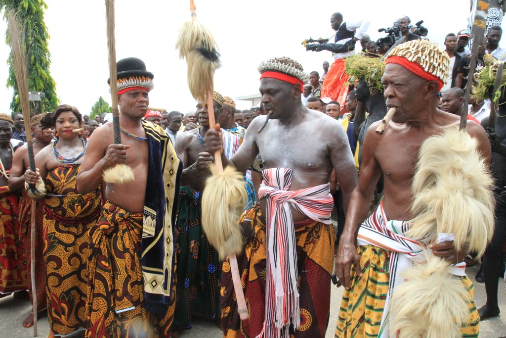
Ugep (also Umor) is a town in the Yakurr Local Government Area in Cross River State, southern Nigeria. The village is populated by the Yakurr people. Ugep as it is popularly known is one of the unit that constitute Yakurr, its indigenes speak the Lokaa Language which is the general language spoken in Yakurr. Ugep originated from a place or village called “Akpa” in the Eastern Ejagham race in the Central senatorial district of Cross River State, Nigeria. The reason why the people of Ugep left Akpa was due to a religious clash between the two paternal families that makes up Akpa in the ritual rites performance in the death of a person from either of the tribe. However, failure of the Ugep people to do the ritual performance for the deceased person is what led to “The Great Trek” where the people of Akpa pursued the people of Ugep out of the village, a man called Edem Omilakpa who was tired and weak with his pregnant wife, pushed a stone from the apex of a hill down to the Apka warriors and the stone killed all the warriors and landed at the feet of the King of Akpa that ends the war between Akpa and the people of Ugep, but the great trek continues. The stone is referred to as: “Ancient wonder and saviour stone ” The people of Ugep did not just leave Akpa without any cultural heritage, they left with most of the cultures that were being practiced in Akpa, and that is the culture they practice till date. Ugep is administered and controlled by the Obol Lopon of Ugep who is the chief priest of Ojokobi (A fertility spirit) he is the central figure in the administrative system with powerful priest called Bi-Nah with their religious role like the Atewa Wu-kang - kang and Opebelede as the chief celebrant of the Ugep New yam festival.
Show more
Sun and Moon
Mon
Tue
Wed
Thu
Fri
Sat
Sun
May 2022
Date and time
00:00
06:00
12:00
18:00
Today
--
--
Sunrise
--
Sunset
--
Moonrise
--
Moonset
Phase
🌔 Waxing Gibbous
The perfect light time for beautiful photos:
--
Sunrise
--
Sunset
PeakVisor app
Get the app on your smartphone
New Panorama Tools
Trace location on the map
Measure distances
All the instruments are available in the context menu as well.
We use GPS information embedded into the photo when it is available.
3D mountains overlay
Adjust mountain panorama to perfectly match your photos because recorded by camera photo position might be imprecise.
Move tool
Rotate tool
Zoom
More customization
Choose which peak labels should make into the final photo and what photo title should be.
Next
Photo Location
Satellitte
Flat map
Relief map
Latitude
Longitude
Altitude
OR
Latitude
°'''
Longitude
°'''
Apply
Register Peak
Peak Name
Latitude
Longitude
Altitude
Register
Teleport
PeakVisor
This 3D model of Sagarmatha National Park in Nepal was made using the PeakVisor app topographic data. The mobile app features higher precision models worldwide, more topographic details, and works offline. Download PeakVisor maps today.
Download OBJ model
PeakVisor
The download should start shortly. If you find it useful please consider supporting the PeakVisor app.
PeakVisor for iOS and Android
Be a superhero of outdoor navigation with state-of-the-art 3D maps and mountain identification in the palm of your hand!