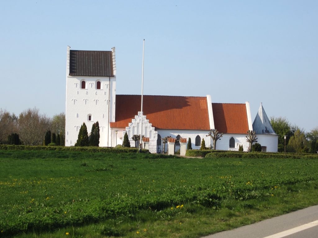
Taulov is a town located in Fredericia Municipality in the eastern part of the Jutland peninsula in Denmark. The town is, with a population of 3,498 (1 January 2024), the second largest in the municipality. Taulov's history is not that well known and it was nothing more than a village until the first railroads in Jutland were built in the 1860s during the industrial revolution. It is now divided into Gammel Taulov (Old Taulov) and Taulov by the motorway, despite Taulov Church being located in Taulov. Old Taulov grew up around the train station and the new main street while the majority of Taulov is squeezed in between the E20 motorway and Kolding Landevej, the old main road between Kolding and Snoghøj, which was the main way to access Eastern Denmark for many centuries. Taulov Church is a medieval church in traditional Danish style, and was constructed in the 13th century. It functioned as a seamark for sailors on Kolding Fjord and Little Belt until modern navigation was introduced. As the natural centre of Taulov, it is located approximate 9 km (5.6 mi) from Fredericia, 10 km (6.2 mi) from Kolding and 20 km (12 mi) from Vejle.
Show more
Sun and Moon
Mon
Tue
Wed
Thu
Fri
Sat
Sun
May 2022
Date and time
00:00
06:00
12:00
18:00
Today
--
--
Sunrise
--
Sunset
--
Moonrise
--
Moonset
Phase
🌔 Waxing Gibbous
The perfect light time for beautiful photos:
--
Sunrise
--
Sunset
PeakVisor app
Get the app on your smartphone
New Panorama Tools
Trace location on the map
Measure distances
All the instruments are available in the context menu as well.
We use GPS information embedded into the photo when it is available.
3D mountains overlay
Adjust mountain panorama to perfectly match your photos because recorded by camera photo position might be imprecise.
Move tool
Rotate tool
Zoom
More customization
Choose which peak labels should make into the final photo and what photo title should be.
Next
Photo Location
Satellitte
Flat map
Relief map
Latitude
Longitude
Altitude
OR
Latitude
°'''
Longitude
°'''
Apply
Register Peak
Peak Name
Latitude
Longitude
Altitude
Register
Teleport
PeakVisor
This 3D model of Sagarmatha National Park in Nepal was made using the PeakVisor app topographic data. The mobile app features higher precision models worldwide, more topographic details, and works offline. Download PeakVisor maps today.
Download OBJ model
PeakVisor
The download should start shortly. If you find it useful please consider supporting the PeakVisor app.
PeakVisor for iOS and Android
Be a superhero of outdoor navigation with state-of-the-art 3D maps and mountain identification in the palm of your hand!