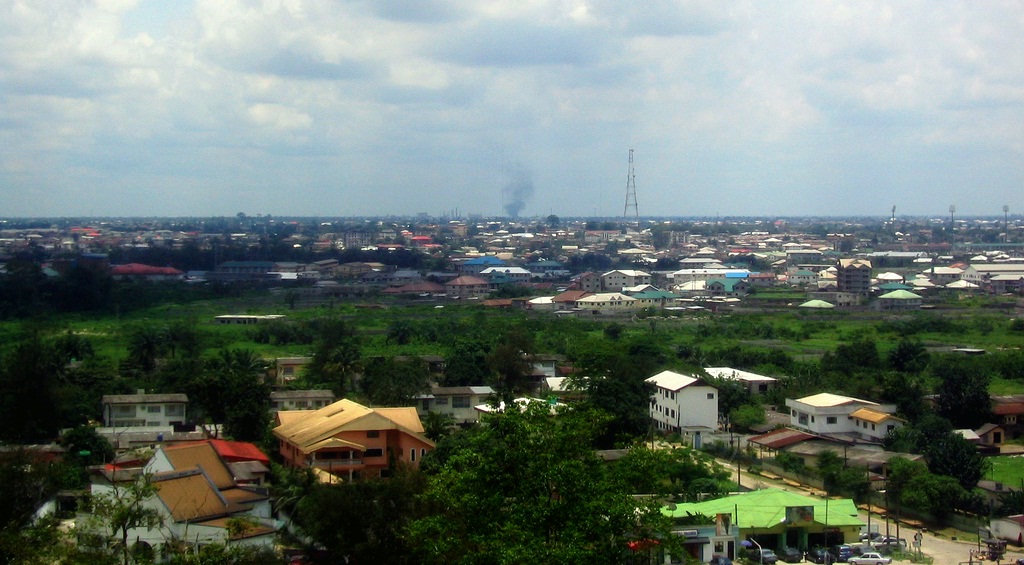
Port Harcourt (Pidgin: Po-ta-kot or Pi-ta-kwa) is the capital and largest city of Rivers State in Nigeria. It is the fifth most populous city in Nigeria after Lagos, Kano, Ibadan and Benin. It lies along the Bonny River and is located in the oil rich Niger Delta. As of 2023, Port Harcourt's urban population is estimated at 3,480,000. The population of the metropolitan area of Port Harcourt is almost twice its urban area population with a 2015 United Nations estimate of 2,344,000. In 1950, the population of Port Harcourt was 59,752. Port Harcourt has grown by 150,844 since 2015, which represents a 4.99% annual change. The area that became Port Harcourt in 1912 was before that of a farmland of people of Rebisi (Ikwerre). The colonial administration of Nigeria created the port to export coal from the collieries of Enugu located 243 kilometres (151 mi) north of Port Harcourt, to which it was linked by a railway called the Eastern Line, also built by the British. Port Harcourt's economy turned to petroleum when the first shipment of Nigerian crude oil was exported through the city in 1958. Through the benefits of the Nigerian petroleum industry, Port Harcourt was further developed, with aspects of modernization such as overpasses, city blocks, and taller and more substantial buildings. Oil firms that currently have offices in the city include Shell and Chevron. There are a number of public and private tertiary institutions in Port Harcourt. These institutions include Rivers State University, University of Port Harcourt, Ken Saro Wiwa Polytechnic, Captain Elechi Amadi Polytechnic, Ignatius Ajuru University, Rivers State College of Health Science and Technology, Madonna University, PAMO University of Medical Sciences, National Open University of Nigeria. The current mayor is Victor Ihunwo. Port Harcourt's primary airport is Port Harcourt International Airport, located on the outskirts of the city; the NAF base is the location of the only other airport and is used by commercial airlines Aero Contractors and Air Nigeria for domestic flights.
Show more
Sun and Moon
Mon
Tue
Wed
Thu
Fri
Sat
Sun
May 2022
Date and time
00:00
06:00
12:00
18:00
Today
--
--
Sunrise
--
Sunset
--
Moonrise
--
Moonset
Phase
🌔 Waxing Gibbous
The perfect light time for beautiful photos:
--
Sunrise
--
Sunset
PeakVisor app
Get the app on your smartphone
New Panorama Tools
Trace location on the map
Measure distances
All the instruments are available in the context menu as well.
We use GPS information embedded into the photo when it is available.
3D mountains overlay
Adjust mountain panorama to perfectly match your photos because recorded by camera photo position might be imprecise.
Move tool
Rotate tool
Zoom
More customization
Choose which peak labels should make into the final photo and what photo title should be.
Next
Photo Location
Satellitte
Flat map
Relief map
Latitude
Longitude
Altitude
OR
Latitude
°'''
Longitude
°'''
Apply
Register Peak
Peak Name
Latitude
Longitude
Altitude
Register
Teleport
PeakVisor
This 3D model of Sagarmatha National Park in Nepal was made using the PeakVisor app topographic data. The mobile app features higher precision models worldwide, more topographic details, and works offline. Download PeakVisor maps today.
Download OBJ model
PeakVisor
The download should start shortly. If you find it useful please consider supporting the PeakVisor app.
PeakVisor for iOS and Android
Be a superhero of outdoor navigation with state-of-the-art 3D maps and mountain identification in the palm of your hand!