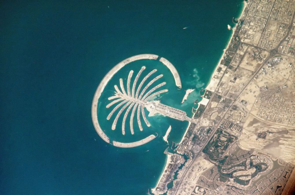
The Palm Jumeirah is an archipelago of artificial islands on the Persian Gulf in Jumeirah, Dubai, United Arab Emirates. It is part of a larger series of developments called the Palm Islands, including Palm Jebel Ali and the Dubai Islands, which, when completed, will together increase Dubai's shoreline by a total of 520 kilometres (320 mi). It has a population of over 25,000 as of 2022. The islands were created using land reclamation. As the name implies, they were created to resemble a palm tree and are roughly divided into three areas: "trunk", "fronds", and "outer crescent". The trunk is a mixed commercial and residential area, the fronds are reserved for residential homes and villas, while the outer crescent is used for luxury and upscale resorts. The Palm Jumeirah construction was done by a Dutch specialist dredging company, Van Oord. The same company also created The World.
Show more
Sun and Moon
Mon
Tue
Wed
Thu
Fri
Sat
Sun
May 2022
Date and time
00:00
06:00
12:00
18:00
Today
--
--
Sunrise
--
Sunset
--
Moonrise
--
Moonset
Phase
🌔 Waxing Gibbous
The perfect light time for beautiful photos:
--
Sunrise
--
Sunset
PeakVisor app
Get the app on your smartphone
New Panorama Tools
Trace location on the map
Measure distances
All the instruments are available in the context menu as well.
We use GPS information embedded into the photo when it is available.
3D mountains overlay
Adjust mountain panorama to perfectly match your photos because recorded by camera photo position might be imprecise.
Move tool
Rotate tool
Zoom
More customization
Choose which peak labels should make into the final photo and what photo title should be.
Next
Photo Location
Satellitte
Flat map
Relief map
Latitude
Longitude
Altitude
OR
Latitude
°'''
Longitude
°'''
Apply
Register Peak
Peak Name
Latitude
Longitude
Altitude
Register
Teleport
PeakVisor
This 3D model of Sagarmatha National Park in Nepal was made using the PeakVisor app topographic data. The mobile app features higher precision models worldwide, more topographic details, and works offline. Download PeakVisor maps today.
Download OBJ model
PeakVisor
The download should start shortly. If you find it useful please consider supporting the PeakVisor app.
PeakVisor for iOS and Android
Be a superhero of outdoor navigation with state-of-the-art 3D maps and mountain identification in the palm of your hand!


.jpg)
.jpg)
.jpg)


