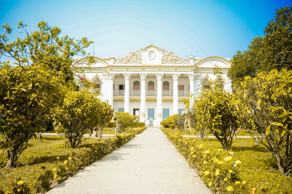
Tangail District is quite famous for its zamindari rule with three of the largest zamindars in the region believed to have been established during the Mughal period. In addition, several small zamindar classes developed in this area, whose reputation is still evident. One of such zamindar is Mohera Zamindar Bari. Mohera Zamindar Bari is a 19th-century Zamidari residence in Mirzapur, Tangail District, Bangladesh. It is used as a police training school. The zamindar house was established in the mirzapur before the 1890s. Mohera zamindar Bari is the most preserved and maintained zamindari Bari of Bangladesh locally. There is no such zamindari Bari as preserved and maintained as it is in the country. The zamindari Bari represents our culture, lifestyle, and history during British time. Mohera Zamindar Bari is spread over an area of about eight (8) acres, about 18 km away from Tangail Sadar in the Dhaka Division of Bangladesh. Mohera Zamindar Bari is located on the Dhaka-Tangail Highway, about 4 km east of Natiapara Bazar. In front of the entrance of this zamindar's house, there is a huge lake called ' Bishakha Sagar' and there are two beautiful gates to enter the house. There are also two more ponds at the back of the main building called Pasra Pond and Rani Pond and there is a beautiful flower garden in the decoration. Adjacent to the Vishakha Sagar, on the south side, there is a huge Amr Kanan and three huge main buildings with Naib Saheb's house, Kachari's house, Gomstad's house, Dighi, and three more lodges.
We use GPS information embedded into the photo when it is available.
3D mountains overlay
Adjust mountain panorama to perfectly match your photos because recorded by camera photo position might be imprecise.
Move tool
Rotate tool
Zoom
More customization
Choose which peak labels should make into the final photo and what photo title should be.
Next
Photo Location
Satellitte
Flat map
Relief map
Latitude
Longitude
Altitude
OR
Latitude
°'''
Longitude
°'''
Apply
Register Peak
Peak Name
Latitude
Longitude
Altitude
Register
Teleport
PeakVisor
This 3D model of Sagarmatha National Park in Nepal was made using the PeakVisor app topographic data. The mobile app features higher precision models worldwide, more topographic details, and works offline. Download PeakVisor maps today.
Download OBJ model
PeakVisor
The download should start shortly. If you find it useful please consider supporting the PeakVisor app.
PeakVisor for iOS and Android
Be a superhero of outdoor navigation with state-of-the-art 3D maps and mountain identification in the palm of your hand!