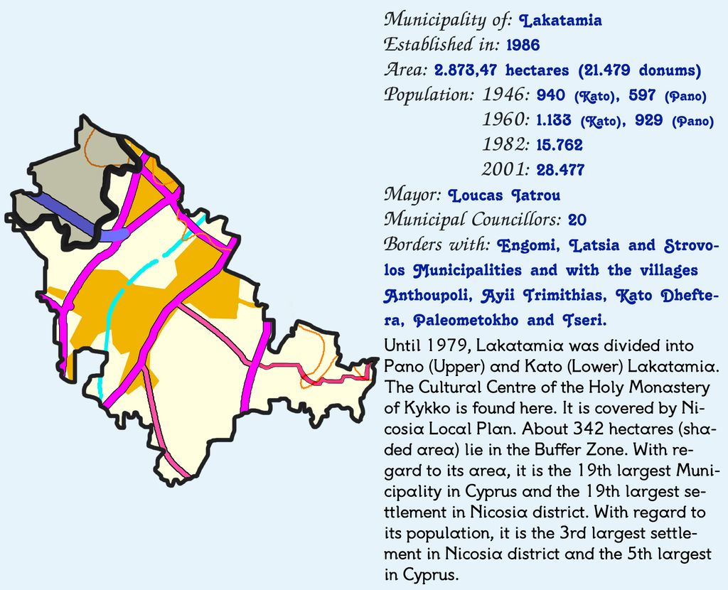
Lakatamia (Greek: Λακατάμια [lakaˈtamɳa]; Turkish: Lakadamya) is a southwestern suburb of Nicosia, Cyprus. In terms of population, Lakatamia municipality is the third largest municipality in Nicosia district and the fifth largest municipality in Cyprus (after Limassol, Strovolos, Nicosia and Larnaca). In 2011 Lakatamia had a population of 38,345. Due to the expansion of the Nicosia urban area, Lakatamia has grown from two small villages (Upper and Lower Lakatamia) into a sizeable suburb. Lower Lakatamia used to be inhabited by both Greek and Turkish Cypriots until the mid-1950s. Its name originates from "alakatia", i.e. wells, which were apparently abundant in the old village. Lakatamia Airfield, an airstrip used by the Cypriot National Guard, is located to the east of Lakatamia. Lakatamia is also home to a football club EN THOI Lakatamia who has played in the Cypriot First Division, however for only one season in their history. THOI usually play in the lower leagues and are currently in the Cypriot Third Division. Cypriot international Valentinos Sielis used to play at the club
Show more
Sun and Moon
Mon
Tue
Wed
Thu
Fri
Sat
Sun
May 2022
Date and time
00:00
06:00
12:00
18:00
Today
--
--
Sunrise
--
Sunset
--
Moonrise
--
Moonset
Phase
🌔 Waxing Gibbous
The perfect light time for beautiful photos:
--
Sunrise
--
Sunset
PeakVisor app
Get the app on your smartphone
New Panorama Tools
Trace location on the map
Measure distances
All the instruments are available in the context menu as well.
We use GPS information embedded into the photo when it is available.
3D mountains overlay
Adjust mountain panorama to perfectly match your photos because recorded by camera photo position might be imprecise.
Move tool
Rotate tool
Zoom
More customization
Choose which peak labels should make into the final photo and what photo title should be.
Next
Photo Location
Satellitte
Flat map
Relief map
Latitude
Longitude
Altitude
OR
Latitude
°'''
Longitude
°'''
Apply
Register Peak
Peak Name
Latitude
Longitude
Altitude
Register
Teleport
PeakVisor
This 3D model of Sagarmatha National Park in Nepal was made using the PeakVisor app topographic data. The mobile app features higher precision models worldwide, more topographic details, and works offline. Download PeakVisor maps today.
Download OBJ model
PeakVisor
The download should start shortly. If you find it useful please consider supporting the PeakVisor app.
PeakVisor for iOS and Android
Be a superhero of outdoor navigation with state-of-the-art 3D maps and mountain identification in the palm of your hand!