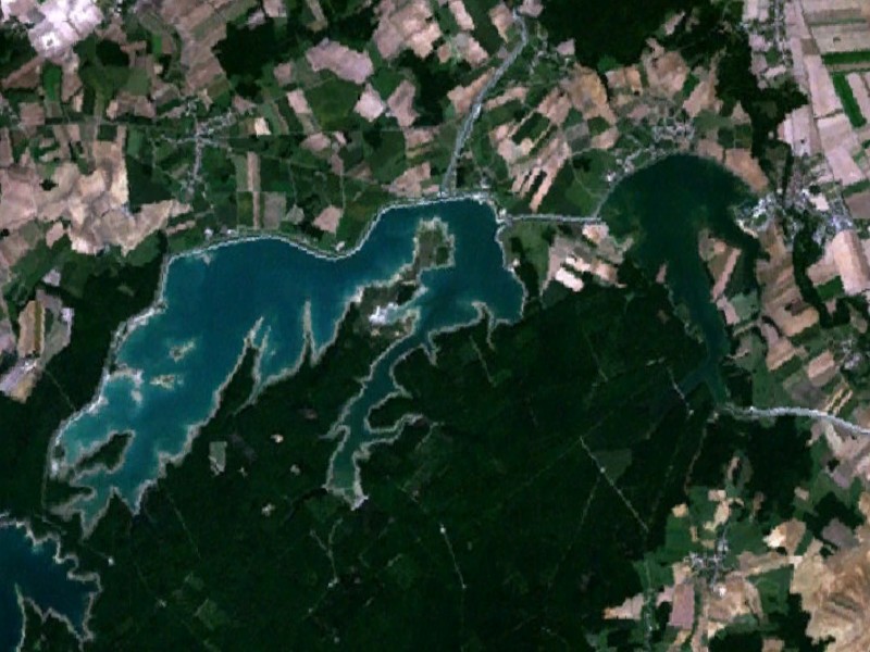
Lakes Amance and du Temple are the two human-made lakes that together form the Aube reservoir. They are located in the Aube department, in the Grand Est region of France. The former is Europe's largest lake reserved for motorboating, and the latter is Europe's largest non-nautical lake. While their normal capacity is 170 hm3, with a total surface area of 23.2 km2 they could, if combined as a single lake, be the third largest man-made lake in France, matching the size of Lac d'Orient. Completed and commissioned in 1989, they are among the last of the great Seine lakes to have been built. Like the neighboring Lac d'Orient, they are part of the Orient Forest Regional Natural Park, created in 1970, twenty years before the project was completed. The two lakes, linked by a channel, were designed to protect Paris and its conurbation from the devastating floods of the Seine, into which the Aube flows. They were also given secondary functions: while Lake Amance, to the east, was dedicated to motorboating, Lac du Temple, to the west, was given over to nature discovery.
We use GPS information embedded into the photo when it is available.
3D mountains overlay
Adjust mountain panorama to perfectly match your photos because recorded by camera photo position might be imprecise.
Move tool
Rotate tool
Zoom
More customization
Choose which peak labels should make into the final photo and what photo title should be.
Next
Photo Location
Satellitte
Flat map
Relief map
Latitude
Longitude
Altitude
OR
Latitude
°'''
Longitude
°'''
Apply
Register Peak
Peak Name
Latitude
Longitude
Altitude
Register
Teleport
PeakVisor
This 3D model of Sagarmatha National Park in Nepal was made using the PeakVisor app topographic data. The mobile app features higher precision models worldwide, more topographic details, and works offline. Download PeakVisor maps today.
Download OBJ model
PeakVisor
The download should start shortly. If you find it useful please consider supporting the PeakVisor app.
PeakVisor for iOS and Android
Be a superhero of outdoor navigation with state-of-the-art 3D maps and mountain identification in the palm of your hand!