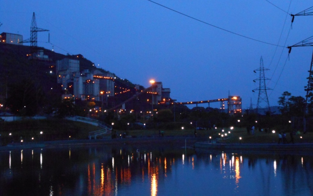
Joda Town is a town and municipality in Keonjhar district, popularly known as Joda Municipality Town in Joda Block, located near Barbil City or Barbil Tahsil which is only 14 km away from. Joda Town is surrounded by the well-known Mahendragiri Parvat Shrunkhala- an ancient series of hills described in history of Bharata Varsha and in the epic Ramayana and Mahabharata, which are spread in from Keonjhar to Sundargarh, Koraput, Kandhamal, Rayagada and Visakhapatnam. Integration of anciently known ‘Joda Village’, ‘Baneikala Village’ and ‘Banspani Village’ is now-a-days so called Joda Municipality Town is strategically created as like a mining camp/base like the temporary military base/camps. Here people used to come or bring by the industries from various places of the country for mining activities/processes only. It can be said the Town is just act like the labour supplier camp to the Mines. The name ‘Joda’ is derived from a small tribal village ‘Joda Village’ which is now known as ‘Joda Basti’ is now located near Bus Stop square. In the past ‘Joda Village’ was one of the beautiful natural areas surrounded by waterfalls and man-mohak deep forests like the heaven on earth. But now-a-days, so called ‘Joda Town’ is a forest destroyed mining camp of labours, started by TATA Group with the help of Britishers. They destroying the beauty of earth by destroying the hills one by one. In past years, only TATA Group was engaged here for earth mining, but now-a-days, multiple red eye industries settled their camps here and started mining in nearby areas. And, central government’s Indian Railways, which is totally based on Britishers Ideas and now also running like the past loot process, interested for vast extraction of Iron Ores to enhance the destruction/mining process. A movie Disney+ Hotstar’s Aar Ya Paar (TV series) is a well described movie on this, based on how the industries are used to grow their money at the cost of destruction of nature in the name of fake development, which indicates the danger situations for entire Human Being Society in future. Once upon a time, the innocent tribals were known as the ‘GUARDIANS OF THE EARTH’ as they protect the beautiful Jewells of earth the forests without any demand/needs as living for Each-Other. The movie cleverly shows the comparison between simplicity and modernity. Joda Municipality Town or Joda Town have a railway station Banspani in its 13-no. ward in Banshapani village. Banspani is the smallest station in the world, just carved out from BSPX Railway Siding with a small retaining wall and having only 1-platform of 280meter length, suitable to cater only 8-LHB coaches. This station is undeveloped because of negligence of Municipal authorities. There is no any direct approach road from Joda Municipality Town to this station, so people hesitate to go there which is the major reason of trains are running through Banspani signs low patronage and Indian Railways hesitates to run any new trains to or through this Town. This also cause that Banspani Station is rejected and Jaroli railway station of Jurudi Gram Panchayat is selected for Amrit Bharat Station development scheme. A second entrance proposed near the pond (Town side location and North-West side from the current station building) but the Indian Railways is hesitating to acquire land from the industries working there. If the new station building will be created, then the people can approach there by a direct proper road from the Town (a direct road from town’s Joda CHC to that town side new planned entrance building near the pond). Also a integrated bus terminal project at opposite of Joda CHC will help to establish a proper communication system of the Town, so everyone can easily reach there. Also a new station is proposed at near JBCN in the name of Joda-Nagar.
Show more
Sun and Moon
Mon
Tue
Wed
Thu
Fri
Sat
Sun
May 2022
Date and time
00:00
06:00
12:00
18:00
Today
--
--
Sunrise
--
Sunset
--
Moonrise
--
Moonset
Phase
🌔 Waxing Gibbous
The perfect light time for beautiful photos:
--
Sunrise
--
Sunset
PeakVisor app
Get the app on your smartphone
New Panorama Tools
Trace location on the map
Measure distances
All the instruments are available in the context menu as well.
We use GPS information embedded into the photo when it is available.
3D mountains overlay
Adjust mountain panorama to perfectly match your photos because recorded by camera photo position might be imprecise.
Move tool
Rotate tool
Zoom
More customization
Choose which peak labels should make into the final photo and what photo title should be.
Next
Photo Location
Satellitte
Flat map
Relief map
Latitude
Longitude
Altitude
OR
Latitude
°'''
Longitude
°'''
Apply
Register Peak
Peak Name
Latitude
Longitude
Altitude
Register
Teleport
PeakVisor
This 3D model of Sagarmatha National Park in Nepal was made using the PeakVisor app topographic data. The mobile app features higher precision models worldwide, more topographic details, and works offline. Download PeakVisor maps today.
Download OBJ model
PeakVisor
The download should start shortly. If you find it useful please consider supporting the PeakVisor app.
PeakVisor for iOS and Android
Be a superhero of outdoor navigation with state-of-the-art 3D maps and mountain identification in the palm of your hand!