Elevation is the altitude of a place above sea level.
About
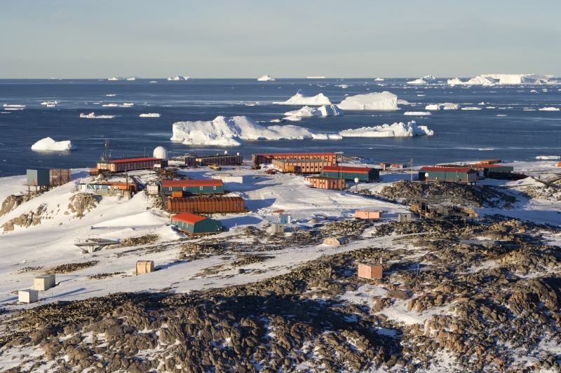
Petrel Island (French: Île des Pétrels) is a rocky island, 900 m long and 45 m in elevation, which lies north-west of Rostand Island and is the largest feature in the cluster of islands at the south-eastern end of Géologie Archipelago. It was photographed from the air by U.S. Navy Operation Highjump, 1946–47, charted by the French Antarctic Expedition, 1949–51, and so named by them because numerous snow petrel nests present. In January 1952, following destruction of the Port Martin base by fire, the French Antarctic Expedition under Marret, 1952–53, enlarged the hut on Petrel Island to serve as the new base site. The island is now the site of Dumont d'Urville Station.
Show more
Sun and Moon
Mon
Tue
Wed
Thu
Fri
Sat
Sun
May 2022
Date and time
00:00
06:00
12:00
18:00
Today
--
--
Sunrise
--
Sunset
--
Moonrise
--
Moonset
Phase
🌔 Waxing Gibbous
The perfect light time for beautiful photos:
--
Sunrise
--
Sunset
PeakVisor app
Get the app on your smartphone
New Panorama Tools
Trace location on the map
Measure distances
All the instruments are available in the context menu as well.
We use GPS information embedded into the photo when it is available.
3D mountains overlay
Adjust mountain panorama to perfectly match your photos because recorded by camera photo position might be imprecise.
Move tool
Rotate tool
Zoom
More customization
Choose which peak labels should make into the final photo and what photo title should be.
Next
Photo Location
Satellitte
Flat map
Relief map
Latitude
Longitude
Altitude
OR
Latitude
°'''
Longitude
°'''
Apply
Register Peak
Peak Name
Latitude
Longitude
Altitude
Register
Teleport
PeakVisor
This 3D model of Sagarmatha National Park in Nepal was made using the PeakVisor app topographic data. The mobile app features higher precision models worldwide, more topographic details, and works offline. Download PeakVisor maps today.
Download OBJ model
PeakVisor
The download should start shortly. If you find it useful please consider supporting the PeakVisor app.
PeakVisor for iOS and Android
Be a superhero of outdoor navigation with state-of-the-art 3D maps and mountain identification in the palm of your hand!