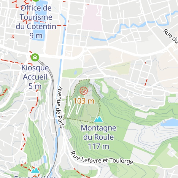
The Fort du Roule is a collection of French and German fortifications built in the nineteenth and twentieth centuries on the Roule mountain in Cherbourg (Cherbourg-en-Cotentin since 2016). The first fortifications were built in 1793 to protect the Bay of Cherbourg from English attacks. The current fort, at the top of the mountain, was built between 1853 and 1857 under Napoleon III. In 1928, the Navy built extensive tunnels under it to store equipment. During the Second World War, the Todt Organisation built several tunnels, installed casemates for artillery, and built gun emplacements. The fort was captured after fierce fighting by the U.S. Army on June 26, 1944. After the war, the Navy took possession of the site and set up its command post in the first maritime region until 1988, when part of the site became a naval communications center. The School of Military Applications of Atomic Energy uses some of the facilities. The fortifications at the top of the mountain now house the Cherbourg Liberation Museum, and the tunnels leading to the German gun emplacements are open to the public.
Show more
Sun and Moon
Mon
Tue
Wed
Thu
Fri
Sat
Sun
May 2022
Date and time
00:00
06:00
12:00
18:00
Today
--
--
Sunrise
--
Sunset
--
Moonrise
--
Moonset
Phase
🌔 Waxing Gibbous
The perfect light time for beautiful photos:
--
Sunrise
--
Sunset
PeakVisor app
Get the app on your smartphone
New Panorama Tools
Trace location on the map
Measure distances
All the instruments are available in the context menu as well.
We use GPS information embedded into the photo when it is available.
3D mountains overlay
Adjust mountain panorama to perfectly match your photos because recorded by camera photo position might be imprecise.
Move tool
Rotate tool
Zoom
More customization
Choose which peak labels should make into the final photo and what photo title should be.
Next
Photo Location
Satellitte
Flat map
Relief map
Latitude
Longitude
Altitude
OR
Latitude
°'''
Longitude
°'''
Apply
Register Peak
Peak Name
Latitude
Longitude
Altitude
Register
Teleport
PeakVisor
This 3D model of Sagarmatha National Park in Nepal was made using the PeakVisor app topographic data. The mobile app features higher precision models worldwide, more topographic details, and works offline. Download PeakVisor maps today.
Download OBJ model
PeakVisor
The download should start shortly. If you find it useful please consider supporting the PeakVisor app.
PeakVisor for iOS and Android
Be a superhero of outdoor navigation with state-of-the-art 3D maps and mountain identification in the palm of your hand!