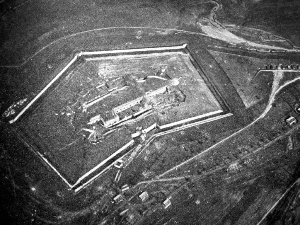
Fort Douaumont (French: Fort de Douaumont) was the largest and highest fort on the ring of 19 large defensive works which had protected the city of Verdun, France, since the 1890s. By 1915, the French General Staff had concluded that even the best-protected forts of Verdun could not withstand bombardments from the German 420 mm (16.5 in) Gamma guns. These new super-heavy howitzers had easily taken several large Belgian forts out of action in August 1914. Fort Douaumont and other Verdun forts were judged ineffective and had been partly disarmed and left virtually undefended since 1915. On 25 February 1916, Fort Douaumont was entered and occupied without a fight by a small German raiding party comprising only 19 officers and 79 men, entering via an open window by the moat. The easy fall of Fort Douaumont, only three days after the beginning of the Battle of Verdun, shocked the French Army. It set the stage for the rest of a battle which lasted nine months, at enormous human cost. Douaumont was finally recaptured by three infantry divisions of the Second Army, during the First Offensive Battle of Verdun on 24 October 1916. This event brought closure to the battle in 1916.
Show more
Sun and Moon
Mon
Tue
Wed
Thu
Fri
Sat
Sun
May 2022
Date and time
00:00
06:00
12:00
18:00
Today
--
--
Sunrise
--
Sunset
--
Moonrise
--
Moonset
Phase
🌔 Waxing Gibbous
The perfect light time for beautiful photos:
--
Sunrise
--
Sunset
PeakVisor app
Get the app on your smartphone
New Panorama Tools
Trace location on the map
Measure distances
All the instruments are available in the context menu as well.
We use GPS information embedded into the photo when it is available.
3D mountains overlay
Adjust mountain panorama to perfectly match your photos because recorded by camera photo position might be imprecise.
Move tool
Rotate tool
Zoom
More customization
Choose which peak labels should make into the final photo and what photo title should be.
Next
Photo Location
Satellitte
Flat map
Relief map
Latitude
Longitude
Altitude
OR
Latitude
°'''
Longitude
°'''
Apply
Register Peak
Peak Name
Latitude
Longitude
Altitude
Register
Teleport
PeakVisor
This 3D model of Sagarmatha National Park in Nepal was made using the PeakVisor app topographic data. The mobile app features higher precision models worldwide, more topographic details, and works offline. Download PeakVisor maps today.
Download OBJ model
PeakVisor
The download should start shortly. If you find it useful please consider supporting the PeakVisor app.
PeakVisor for iOS and Android
Be a superhero of outdoor navigation with state-of-the-art 3D maps and mountain identification in the palm of your hand!