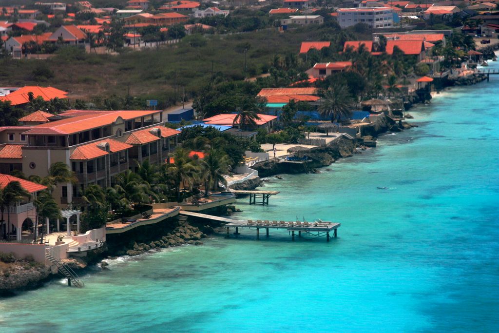
Bonaire ( bon-AIR, Dutch: [boːˈnɛːr(ə)] ; Papiamento: [bʊˈne̝i̯ru]) is a Caribbean island in the Leeward Antilles, and is a special municipality (officially "public body") of the Netherlands. Its capital is the port of Kralendijk, on the west (leeward) coast of the island. Aruba, Bonaire and Curaçao form the ABC islands, 80 km (50 miles) off the coast of Venezuela. The islands have an arid climate that attracts visitors seeking warm, sunny weather all year round, and they lie outside the Main Development Region for tropical cyclones. Bonaire is a popular snorkeling and scuba diving destination because of its multiple shore diving sites, shipwrecks and easy access to the island's fringing reefs. As of 1 January 2023, the island's population totaled 24,090 permanent residents, an increase of over 7,500 (or 45.6%) since 2012. The island's total land area is 288 square kilometres (111 sq mi); it is 38.6 kilometres (24.0 mi) long from north to south, and ranges from 5–8 km (3–5 mi) wide from east to west. A short 800 metres (0.50 mi) west of Bonaire across the sea is the uninhabited islet Klein Bonaire with a total land area of 6 km2 (2.3 sq mi). Klein Bonaire has low-growing vegetation including cactus (Papiamentu: kadushi), with sparse palm trees near the water and is bordered by white sandy beaches and a fringing reef. The reefs, beaches and on-island reserves located on both Bonaire and Klein Bonaire are under the protection of the Bonaire National Marine Park, and managed by Stichting Nationale Parken Bonaire (STINAPA). Bonaire was part of the Netherlands Antilles until the country's dissolution in 2010, when the island became a special municipality (officially, a "Caribbean public body") within the country of the Netherlands. It is one of three special municipalities in the Caribbean; the others are Sint Eustatius and Saba. 80% of Bonaire's population are Dutch nationals, and nearly 60% of its residents were born in the former Netherlands Antilles and Aruba.
Show more
Sun and Moon
Mon
Tue
Wed
Thu
Fri
Sat
Sun
May 2022
Date and time
00:00
06:00
12:00
18:00
Today
--
--
Sunrise
--
Sunset
--
Moonrise
--
Moonset
Phase
🌔 Waxing Gibbous
The perfect light time for beautiful photos:
--
Sunrise
--
Sunset
PeakVisor app
Get the app on your smartphone
New Panorama Tools
Trace location on the map
Measure distances
All the instruments are available in the context menu as well.
We use GPS information embedded into the photo when it is available.
3D mountains overlay
Adjust mountain panorama to perfectly match your photos because recorded by camera photo position might be imprecise.
Move tool
Rotate tool
Zoom
More customization
Choose which peak labels should make into the final photo and what photo title should be.
Next
Photo Location
Satellitte
Flat map
Relief map
Latitude
Longitude
Altitude
OR
Latitude
°'''
Longitude
°'''
Apply
Register Peak
Peak Name
Latitude
Longitude
Altitude
Register
Teleport
PeakVisor
This 3D model of Sagarmatha National Park in Nepal was made using the PeakVisor app topographic data. The mobile app features higher precision models worldwide, more topographic details, and works offline. Download PeakVisor maps today.
Download OBJ model
PeakVisor
The download should start shortly. If you find it useful please consider supporting the PeakVisor app.
PeakVisor for iOS and Android
Be a superhero of outdoor navigation with state-of-the-art 3D maps and mountain identification in the palm of your hand!


.jpg)


