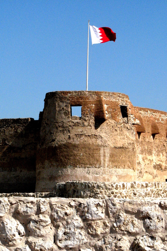
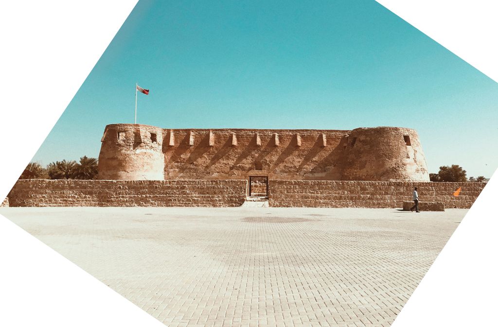
Arad Fort (Arabic: قلعة عراد, Qal'at 'Arad) is a 15th-century fort in Arad, Bahrain. Formerly guarding a separate island of its own, the fort and its surroundings have since been joined to Muharraq Island. Arad Fort was built in the typical style of Islamic forts during the 15th century before the Portuguese invasion of Bahrain in AD 1622. This fort has a beautiful history. A few feuds between the Islamic divisions of Bahrain have taken place here. This fort is one of the compact defensive forts in Bahrain. In its present location, it overlooks various sea passages of Muharraq's shallow seashores. In the past, there was an inaccessible marine channel which was controlled by the local people to prevent ships from breaking through to the island where the fort is located. The fort is square and on every corner there is a cylindrical tower. It is surrounded by a small trench which used to be filled with water from wells that were drilled especially for this purpose. In every corner of the upper wall of the fort there are nose shaped openings for marksmen. Close to the Bahrain International Airport, the fort has been extensively restored and is illuminated at night. Traditional materials have been used in the restoration and maintenance of the fort after making extensive analysis of the original materials such as sea stones, lime, sand, and palm trunks. See Walls, Archibald G., Senior Architect, Ministry of Information, State of Bahrain, Arad Fort: Its restoration, its history and defences, February 1987, Pub. Directorate of Tourism and Archaeology, Ministry of Information, State of Bahrain No cement or any other materials which are not in harmony with the historical building or which reduce its historical value have not been used.
Show more
Sun and Moon
Mon
Tue
Wed
Thu
Fri
Sat
Sun
May 2022
Date and time
00:00
06:00
12:00
18:00
Today
--
--
Sunrise
--
Sunset
--
Moonrise
--
Moonset
Phase
🌔 Waxing Gibbous
The perfect light time for beautiful photos:
--
Sunrise
--
Sunset
PeakVisor app
Get the app on your smartphone
New Panorama Tools
Trace location on the map
Measure distances
All the instruments are available in the context menu as well.
We use GPS information embedded into the photo when it is available.
3D mountains overlay
Adjust mountain panorama to perfectly match your photos because recorded by camera photo position might be imprecise.
Move tool
Rotate tool
Zoom
More customization
Choose which peak labels should make into the final photo and what photo title should be.
Next
Photo Location
Satellitte
Flat map
Relief map
Latitude
Longitude
Altitude
OR
Latitude
°'''
Longitude
°'''
Apply
Register Peak
Peak Name
Latitude
Longitude
Altitude
Register
Teleport
PeakVisor
This 3D model of Sagarmatha National Park in Nepal was made using the PeakVisor app topographic data. The mobile app features higher precision models worldwide, more topographic details, and works offline. Download PeakVisor maps today.
Download OBJ model
PeakVisor
The download should start shortly. If you find it useful please consider supporting the PeakVisor app.
PeakVisor for iOS and Android
Be a superhero of outdoor navigation with state-of-the-art 3D maps and mountain identification in the palm of your hand!


.jpg)


