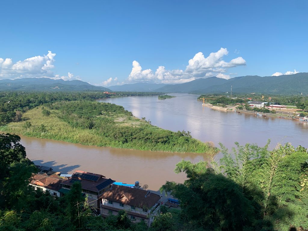
The Golden Triangle is a large, mountainous region of approximately 200,000 km2 (77,000 sq mi) in northeastern Myanmar, northwestern Thailand and northern Laos, centered on the confluence of the Ruak and Mekong rivers. The name "Golden Triangle" was coined by Marshall Green, a U.S. State Department official, in 1971 in a press conference on the opium trade. Today, the Thai side of the river confluence, Sop Ruak, has become a tourist attraction, with the House of Opium Museum, a Hall of Opium, and a Golden Triangle Park, and no opium cultivation. The Golden Triangle has been one of the largest opium-producing areas of the world since the 1950s. Most of the world's heroin came from the Golden Triangle until the early 21st century when opium production in Afghanistan increased. Myanmar was the world's second-largest source of opium after Afghanistan up to 2022, producing some 25% of the world's opium, forming part of the Golden Triangle. While opium poppy cultivation in Myanmar had declined year-on-year since 2015, cultivation area increased by 33% totalling 40,100 ha (99,000 acres) alongside an 88% increase in yield potential to 790 t (780 long tons; 870 short tons) in 2022 according to latest data from the United Nations Office on Drugs and Crime (UNODC) Myanmar Opium Survey 2022. The United Nations Office on Drugs and Crime has also warned that opium production in Myanmar may rise again if the economic crunch brought on by COVID-19 and the country's 2021 Myanmar coup d'état persists, with significant public health and security consequences for much of Asia. In 2023, Myanmar became the world’s largest producer of opium after an estimated 1,080 t (1,060 long tons; 1,190 short tons) of the drug was produced, according to a United Nations Office on Drugs and Crime report, while a crackdown by the Taliban reduced opium production by approximately 95% to 330 t (320 long tons; 360 short tons) in Afghanistan for the same year.
Show more
Sun and Moon
Mon
Tue
Wed
Thu
Fri
Sat
Sun
May 2022
Date and time
00:00
06:00
12:00
18:00
Today
--
--
Sunrise
--
Sunset
--
Moonrise
--
Moonset
Phase
🌔 Waxing Gibbous
The perfect light time for beautiful photos:
--
Sunrise
--
Sunset
PeakVisor app
Get the app on your smartphone
New Panorama Tools
Trace location on the map
Measure distances
All the instruments are available in the context menu as well.
We use GPS information embedded into the photo when it is available.
3D mountains overlay
Adjust mountain panorama to perfectly match your photos because recorded by camera photo position might be imprecise.
Move tool
Rotate tool
Zoom
More customization
Choose which peak labels should make into the final photo and what photo title should be.
Next
Photo Location
Satellitte
Flat map
Relief map
Latitude
Longitude
Altitude
OR
Latitude
°'''
Longitude
°'''
Apply
Register Peak
Peak Name
Latitude
Longitude
Altitude
Register
Teleport
PeakVisor
This 3D model of Sagarmatha National Park in Nepal was made using the PeakVisor app topographic data. The mobile app features higher precision models worldwide, more topographic details, and works offline. Download PeakVisor maps today.
Download OBJ model
PeakVisor
The download should start shortly. If you find it useful please consider supporting the PeakVisor app.
PeakVisor for iOS and Android
Be a superhero of outdoor navigation with state-of-the-art 3D maps and mountain identification in the palm of your hand!