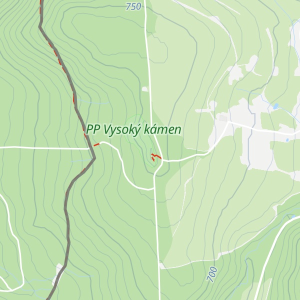
Vysoký kámen (German: Hoher Stein) is a hill and a nature monument in the territory of Kraslice in the Karlovy Vary Region of the Czech Republic. It lies in the Elster Mountains (part of the Fichtel Mountains), 1 km from the Czech-German border.
The ridge of rocks at the summit resemble a ruined castle. It is the western rocks that are used by climbers. They are ideal for beginners, with some low difficulty routes. It is also in the west that one finds the highest point, which rises to 780 m. It can be reached by means of a bridge and steel steps- forming a popular panorama point.
The ridge continues in a wall like formation, terminating at the eastern end with the Felsturm Zobák (Schnabel) and the monumental Felsen Vêtrná skála (Windfelsen). Near these precipitous formations is a Felsenmeer, a sea of free standing boulders that are in parts united with clay. The rocks are Quartz on a bed of slate. Vysoký kámen is protected as a nature monument since 1907. Even so, since then it has been threatened by quarrying four times.
At the end of World War II, countless fleeing German soldiers used Vysoký kámen as their exit route from German Sudetenland, which was reclassified as Czechoslovakia, back into Saxony. They passed through the thick forest from Eubabrunn and Erlbach over the border, avoiding the borderposts of the US Army of Occupation, and thus avoiding imprisonment.
The former restaurant Wirtshaus am Hohen Stein, a well loved daytrip destination was destroyed in 1945 but the 8 m deep well that is hidden in the woods still remains. Vysoký kámen can be reached from Eubabrunn on the Czech side,(using the parking at the Freilichtmuseum). It is about an hour's walk from there. On the German side the path is made up and well signed.
We use GPS information embedded into the photo when it is available.
3D mountains overlay
Adjust mountain panorama to perfectly match your photos because recorded by camera photo position might be imprecise.
Move tool
Rotate tool
Zoom
More customization
Choose which peak labels should make into the final photo and what photo title should be.
Next
Photo Location
Satellitte
Flat map
Relief map
Latitude
Longitude
Altitude
OR
Latitude
°'''
Longitude
°'''
Apply
Register Peak
Peak Name
Latitude
Longitude
Altitude
Register
Teleport
PeakVisor
This 3D model of Sagarmatha National Park in Nepal was made using the PeakVisor app topographic data. The mobile app features higher precision models worldwide, more topographic details, and works offline. Download PeakVisor maps today.
Download OBJ model
PeakVisor
The download should start shortly. If you find it useful please consider supporting the PeakVisor app.
PeakVisor for iOS and Android
Be a superhero of outdoor navigation with state-of-the-art 3D maps and mountain identification in the palm of your hand!


.jpg)
.jpg)
.jpg)
.jpg)
.jpg)
.jpg)
.jpg)
.jpg)
.jpg)