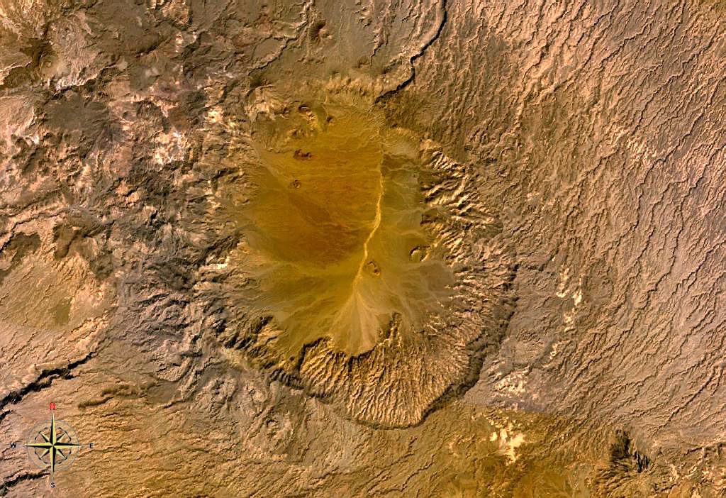
The Tarso Voon is a 3,100-metre (10,200 ft) high stratovolcano in the north of the Republic of Chad. It is located in the western center of the Tibesti Mountains.
The summit of the mountain is dominated by the 14-by-18-kilometre (8.7 mi × 11.2 mi) relatively flat caldera. Extensive basaltic flows lie on the northeastern side in a 180-degree arc and are a result of the high activity in the Quaternary. In the neighborhood in northwestern direction is the Ehi Mousgau, a stratovolcano with the same elevation, 3,100 metres (10,200 ft) above sea level. Deposits from pyroclastic clouds are found 15 to 35 kilometres (9.3 to 21.7 mi) around the caldera. The mountain was constructed over a basement of Precambrian schists.
The well known Soborom Solfataric field is the largest in the Tibesti Mountains, it is located about 5 kilometres (3.1 mi) west of the summit rim. The active fumaroles, mudpots and hot springs are visited by the people of the Tibesti for medical purposes.
By elevation Tarso Voon is
# 12 out of 1734 in Chad # 12 out of 425 in Tibesti # 12 out of 291 in the Tibesti Mountains
By prominence Tarso Voon is
# 30 out of 1734 in Chad # 17 out of 425 in Tibesti # 18 out of 291 in the Tibesti Mountains
We use GPS information embedded into the photo when it is available.
3D mountains overlay
Adjust mountain panorama to perfectly match your photos because recorded by camera photo position might be imprecise.
Move tool
Rotate tool
Zoom
More customization
Choose which peak labels should make into the final photo and what photo title should be.
Next
Photo Location
Satellitte
Flat map
Relief map
Latitude
Longitude
Altitude
OR
Latitude
°'''
Longitude
°'''
Apply
Register Peak
Peak Name
Latitude
Longitude
Altitude
Register
Teleport
PeakVisor
This 3D model of Sagarmatha National Park in Nepal was made using the PeakVisor app topographic data. The mobile app features higher precision models worldwide, more topographic details, and works offline. Download PeakVisor maps today.
Download OBJ model
PeakVisor
The download should start shortly. If you find it useful please consider supporting the PeakVisor app.
PeakVisor for iOS and Android
Be a superhero of outdoor navigation with state-of-the-art 3D maps and mountain identification in the palm of your hand!