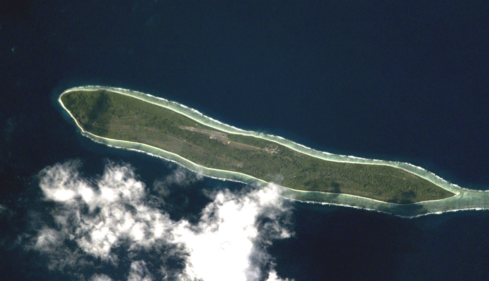
Agaléga (French: îles Agaléga) is a dependency of Mauritius, as defined by the Constitution of Mauritius, which consists of two outer islands located in the Indian Ocean, about 1,050 km (650 mi) north of Mauritius Island.
Similarly to other Mauritian islands such as St. Brandon, Agaléga is run directly by the Prime Minister of Mauritius through the Prime Minister's Office to the Outer Island Development Corporation (OIDC). The population of the islands rose from 289 in 2011 to 330 in 2022.
The islands have a total area of 2,600 ha (6,400 acres). The North island is 12.5 km (7.8 mi) long and 1.5 km (0.9 mi) wide, while the South island is 7 km (4.3 mi) long and 4.5 km (2.8 mi) wide. The North Island is home to the islands' airstrip and the capital Vingt-Cinq. The islands are known for their production of coconuts, their main industry and, also, for the Agalega day gecko.
A 2015 memorandum of understanding on India–Mauritius military cooperation envisaged developing the Agaléga islands for an Indian military base. Local residents vocally opposed construction of the base as being a threat to local employment, self-determination, creole language (Agalega creole) and culture and Mauritian sovereignty. These recent infrastructural development by India, for civil and military use, have significantly transformed the islands' landscape.
There's a trail leading to the summit.
Show more
Sun and Moon
Mon
Tue
Wed
Thu
Fri
Sat
Sun
May 2022
Date and time
00:00
06:00
12:00
18:00
Today
--
--
Sunrise
--
Sunset
--
Moonrise
--
Moonset
Phase
🌔 Waxing Gibbous
The perfect light time for beautiful photos:
--
Sunrise
--
Sunset
PeakVisor app
Get the app on your smartphone
New Panorama Tools
Trace location on the map
Measure distances
All the instruments are available in the context menu as well.
We use GPS information embedded into the photo when it is available.
3D mountains overlay
Adjust mountain panorama to perfectly match your photos because recorded by camera photo position might be imprecise.
Move tool
Rotate tool
Zoom
More customization
Choose which peak labels should make into the final photo and what photo title should be.
Next
Photo Location
Satellitte
Flat map
Relief map
Latitude
Longitude
Altitude
OR
Latitude
°'''
Longitude
°'''
Apply
Register Peak
Peak Name
Latitude
Longitude
Altitude
Register
Teleport
PeakVisor
This 3D model of Sagarmatha National Park in Nepal was made using the PeakVisor app topographic data. The mobile app features higher precision models worldwide, more topographic details, and works offline. Download PeakVisor maps today.
Download OBJ model
PeakVisor
The download should start shortly. If you find it useful please consider supporting the PeakVisor app.
PeakVisor for iOS and Android
Be a superhero of outdoor navigation with state-of-the-art 3D maps and mountain identification in the palm of your hand!