Available for connected Garmin and Suunto accounts.
Scan the QR code and open PeakVisor on your phone
Milton, Mount map
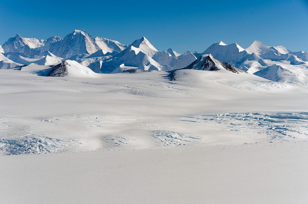
Milton, Mount
N
Add photo
1 773 m
Elevation
Elevation is the altitude of a place above sea level.
About
The Sentinel Range is a major mountain range situated northward of Minnesota Glacier and forming the northern half of the Ellsworth Mountains in Antarctica. The range trends NNW-SSE for about 185 km (115 mi) and is 24 to 48 km (15 to 30 mi) wide. Many peaks rise over 4,000 m (13,100 ft) and Vinson Massif (4892 m) in the southern part of the range is the highest elevation on the continent.
Sentinel Range comprises a main ridge (featuring Vinson Massif in its southern portion) and a number of distinct heights, ridges and mountains on its east side, including (south to north) Owen Ridge, Petvar Heights, Doyran Heights, Veregava Ridge, Flowers Hills, Sullivan Heights, Barnes Ridge, Maglenik Heights, Probuda Ridge, Bangey Heights, Sostra Heights and Gromshin Heights. It is separated from Bastien Range to the southwest by Nimitz Glacier, and from Heritage Range to the south by lower Minnesota Glacier.
The range was first sighted and photographed from the air on November 23, 1935, by Lincoln Ellsworth who in naming it recognized its prominent position as a landmark on an otherwise featureless ice surface. The range was first visited and partially surveyed in January 1958 during the Sentinel Mountains Traverse led by Charles R. Bentley. The entire range was subsequently mapped by USGS from aerial photography taken by the U.S. Navy, 1958-61.
Show more
Sun and Moon
Mon
Tue
Wed
Thu
Fri
Sat
Sun
May 2022
Date and time
00:00
06:00
12:00
18:00
Today
--
--
Sunrise
--
Sunset
--
Moonrise
--
Moonset
Phase
🌔 Waxing Gibbous
The perfect light time for beautiful photos:
--
Sunrise
--
Sunset
PeakVisor app
Get the app on your smartphone
New Panorama Tools
Trace location on the map
Measure distances
All the instruments are available in the context menu as well.
We use GPS information embedded into the photo when it is available.
3D mountains overlay
Adjust mountain panorama to perfectly match your photos because recorded by camera photo position might be imprecise.
Move tool
Rotate tool
Zoom
More customization
Choose which peak labels should make into the final photo and what photo title should be.
Next
Photo Location
Satellitte
Flat map
Relief map
Latitude
Longitude
Altitude
OR
Latitude
°'''
Longitude
°'''
Apply
Register Peak
Peak Name
Latitude
Longitude
Altitude
Register
Teleport
PeakVisor
This 3D model of Sagarmatha National Park in Nepal was made using the PeakVisor app topographic data. The mobile app features higher precision models worldwide, more topographic details, and works offline. Download PeakVisor maps today.
Download OBJ model
PeakVisor
The download should start shortly. If you find it useful please consider supporting the PeakVisor app.
PeakVisor for iOS and Android
Be a superhero of outdoor navigation with state-of-the-art 3D maps and mountain identification in the palm of your hand!