Available for connected Garmin and Suunto accounts.
Scan the QR code and open PeakVisor on your phone
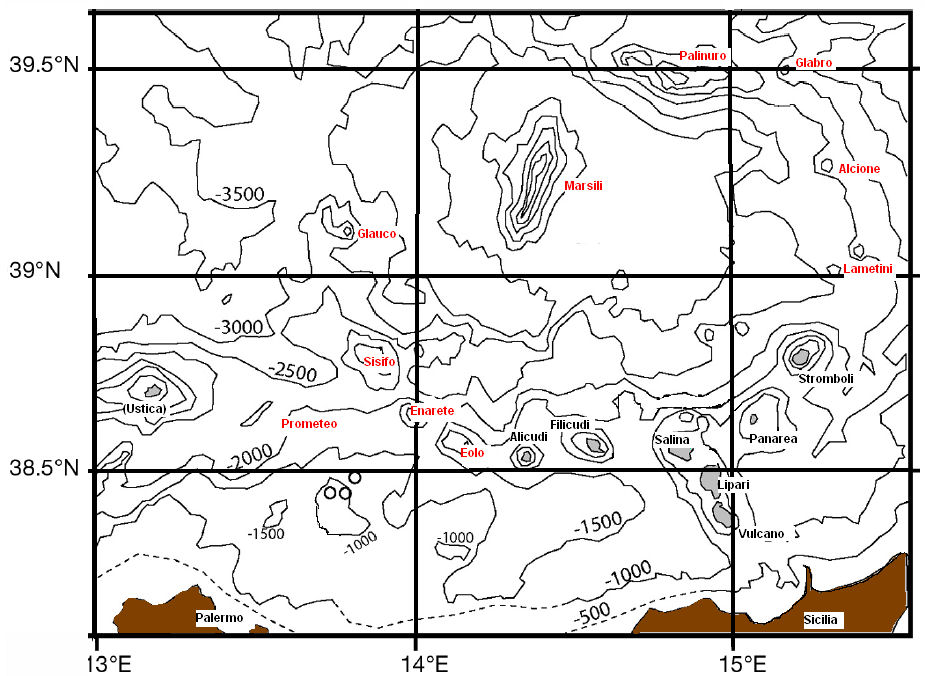
Marsili map
Marsili
F
Add photo
About
Marsili is a large undersea volcano in the Tyrrhenian Sea, about 175 kilometers (109 mi) south of Naples. The seamount is about 3,000 m (9,800 feet) tall; its peak and crater are about 450 m below the sea surface. Though it has not erupted in recorded history, volcanologists believe that Marsili is a relatively fragile-walled structure, made of low-density and unstable rocks, fed by the underlying shallow magma chamber. Volcanologists with the Italian National Institute of Geophysics and Volcanology (INGV) announced on March 29, 2010, that Marsili could erupt at any time, and might experience a catastrophic collapse that would suddenly release vast amounts of magma in an undersea eruption and landslide that could trigger destructive tsunamis on the Italian coast and nearby Mediterranean coastlines.
Show more
Sun and Moon
Mon
Tue
Wed
Thu
Fri
Sat
Sun
May 2022
Date and time
00:00
06:00
12:00
18:00
Today
--
--
Sunrise
--
Sunset
--
Moonrise
--
Moonset
Phase
🌔 Waxing Gibbous
The perfect light time for beautiful photos:
--
Sunrise
--
Sunset
PeakVisor app
Get the app on your smartphone
New Panorama Tools
Trace location on the map
Measure distances
All the instruments are available in the context menu as well.
We use GPS information embedded into the photo when it is available.
3D mountains overlay
Adjust mountain panorama to perfectly match your photos because recorded by camera photo position might be imprecise.
Move tool
Rotate tool
Zoom
More customization
Choose which peak labels should make into the final photo and what photo title should be.
Next
Photo Location
Satellitte
Flat map
Relief map
Latitude
Longitude
Altitude
OR
Latitude
°'''
Longitude
°'''
Apply
Register Peak
Peak Name
Latitude
Longitude
Altitude
Register
Teleport
PeakVisor
This 3D model of Sagarmatha National Park in Nepal was made using the PeakVisor app topographic data. The mobile app features higher precision models worldwide, more topographic details, and works offline. Download PeakVisor maps today.
Download OBJ model
PeakVisor
The download should start shortly. If you find it useful please consider supporting the PeakVisor app.
PeakVisor for iOS and Android
Be a superhero of outdoor navigation with state-of-the-art 3D maps and mountain identification in the palm of your hand!