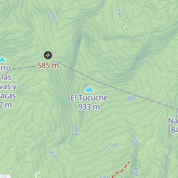
El Tucuche (936 m) is the second highest peak in Trinidad's Northern Range and is noted for its interesting pyramidal shape. It is fabled in Amerindian lore as a sacred mountain. There are Amerindian petroglyphs on a rock outcrop below the mountain. These are the only petroglyphs in country known to archaeologists.
Its summit is home to the golden tree frog (Phytotriades auratus). On the summit of El Tucuche, elfin woodland can be found. The vegetation is usually gnarled and short, due to the high elevation, exposure to clouds and prevailing winds. At the foot of the mountain lies the village of Lluengo, home to approximately 2,000 residents.
Wildlife on El Tucuche includes animals such as the El Tucuche Golden Tree Frog (Phytotriades auratus), the Red Brocket Deer, the Fer-de-lance (Bothrops atrox), the Bearded Bellbird, the Orange-winged Amazon Parrot, the White-bearded Manakin, the Trinidad Stream Frog (Mannophryne trinitatis) and the Emperor Morpho Butterfly (Morpho peleides) to name just a few. Notable vegetation on the higher slopes includes mosses, tree-ferns and bromeliads (including Glomeropitcairnia erectiflora - the microhabitat of the El Tucuche Golden Tree Frog); and Heliconias on the lower to middle slopes. Old abandoned Cocoa estates that are reverting to forest occur in some areas of the lower slopes. The nation's highest waterfall, Maracas falls, lies at the foothills of El Tucuche, and is 91.5 meters (300 feet) high.
El Tucuche is often climbed by hikers. There are two summits, the first summit ascends to above 2,000 feet (610 meters) and displays a 1000 feet sheer-vertical cliff. The second and highest summit is at over 3,000 feet (910 meters) and is pyramid-shaped. When clouds aren't present, the nation's capital, Port Of Spain, the Caroni Swamp and Main Ridge can be viewed from the summit. The mountain also has views of Maracas Beach.
Show more
Sun and Moon
Mon
Tue
Wed
Thu
Fri
Sat
Sun
May 2022
Date and time
00:00
06:00
12:00
18:00
Today
--
--
Sunrise
--
Sunset
--
Moonrise
--
Moonset
Phase
🌔 Waxing Gibbous
The perfect light time for beautiful photos:
--
Sunrise
--
Sunset
PeakVisor app
Get the app on your smartphone
New Panorama Tools
Trace location on the map
Measure distances
All the instruments are available in the context menu as well.
We use GPS information embedded into the photo when it is available.
3D mountains overlay
Adjust mountain panorama to perfectly match your photos because recorded by camera photo position might be imprecise.
Move tool
Rotate tool
Zoom
More customization
Choose which peak labels should make into the final photo and what photo title should be.
Next
Photo Location
Satellitte
Flat map
Relief map
Latitude
Longitude
Altitude
OR
Latitude
°'''
Longitude
°'''
Apply
Register Peak
Peak Name
Latitude
Longitude
Altitude
Register
Teleport
PeakVisor
This 3D model of Sagarmatha National Park in Nepal was made using the PeakVisor app topographic data. The mobile app features higher precision models worldwide, more topographic details, and works offline. Download PeakVisor maps today.
Download OBJ model
PeakVisor
The download should start shortly. If you find it useful please consider supporting the PeakVisor app.
PeakVisor for iOS and Android
Be a superhero of outdoor navigation with state-of-the-art 3D maps and mountain identification in the palm of your hand!