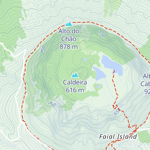
The Caldeira Volcano (Portuguese: Vulcão da Caldeira) is the highest mountain, massive stratovolcano and the largest geomorphological structure that forms the island of Faial. The mountain's highest point, Cabeço Gordo, reaches 1,043 metres (3,422 ft) above sea level. One of the most notable features of this volcano is its two kilometer wide caldera, that is 400 m (1,300 ft) in depth below the crater rim.
By elevation Caldeira is
# 7 out of 7 in Reserva Natural da Caldeira do Faial # 9 out of 20 in Caldeira e Capelinhos Special Area of Conservation # 12 out of 21 in Caldeira e Capelinhos Special Protection Area
By prominence Caldeira is
# 3 out of 7 in Reserva Natural da Caldeira do Faial # 9 out of 20 in Caldeira e Capelinhos Special Area of Conservation # 12 out of 21 in Caldeira e Capelinhos Special Protection Area
We use GPS information embedded into the photo when it is available.
3D mountains overlay
Adjust mountain panorama to perfectly match your photos because recorded by camera photo position might be imprecise.
Move tool
Rotate tool
Zoom
More customization
Choose which peak labels should make into the final photo and what photo title should be.
Next
Photo Location
Satellitte
Flat map
Relief map
Latitude
Longitude
Altitude
OR
Latitude
°'''
Longitude
°'''
Apply
Register Peak
Peak Name
Latitude
Longitude
Altitude
Register
Teleport
PeakVisor
This 3D model of Sagarmatha National Park in Nepal was made using the PeakVisor app topographic data. The mobile app features higher precision models worldwide, more topographic details, and works offline. Download PeakVisor maps today.
Download OBJ model
PeakVisor
The download should start shortly. If you find it useful please consider supporting the PeakVisor app.
PeakVisor for iOS and Android
Be a superhero of outdoor navigation with state-of-the-art 3D maps and mountain identification in the palm of your hand!