
Scan the QR code and open PeakVisor on your phone
Mount Hanang Nature Forest Reserve has 1 named peak. The highest is Mt Hanang at 3,420 m.
The Mount Hanang Nature Forest Reserve is a protected area located in central Tanzania. It contains 5,871 ha (14,508 acres) of terrain and 1 named peak, Mount Hanang, which is 3,420 m (11,220 ft) in elevation and has a prominence of 2,049 m (6,722 ft). Mount Hanang is the fourth-tallest peak in Tanzania, and it is generally a more affordable hiking option when compared to Kilimanjaro and Mount Meru.
The Mount Hanang Nature Forest Reserve in central Tanzania is a protected area that’s located in the Hanang District of the Manyara Region. It includes 5,871 ha (14,508 acres) of terrain and encompasses the entirety of Mount Hanang—Tanzania’s fourth-tallest peak after Kilimanjaro, Mount Meru, and Mount Loolmalasin.
As it is located 4 km (2.5 mi) to the north of Katesh, the main entrance to the park is via Katesh, which leads you to the southern side of Mount Hanang. Alternatively, visitors can enter the park through the village of Giting, which is located along the eastern side of the reserve. Surrounding the mountain are two alkaline lakes—Balang’dalalu and Gendabi—and incredible acacia forests.
Mount Hanang is also known for its steep slopes. The western side of the mountain is much rockier than the rest of the reserve as it features rugged ridges and densely forested valleys. The southern and eastern slopes of the reserve are covered by forests. The rivers and seasonal streams that run through the forest reserve are also what supplies water for most of the Hanang District.
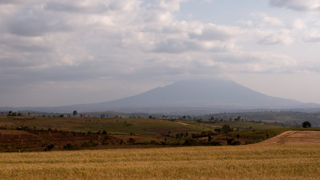
Mount Hanang is an extinct stratovolcano that’s located along the eastern arm of the Great Rift Valley.
The volcano last erupted during the Pleistocene epoch. The core of the extinct volcano is composed primarily of nephenlinitic lavas and carbonatitic tufts. The large, south-sloping valley on Hanang is thought to be the remnants of a collapsed crater. Soils in the area consist of red clay and sand, and they are mostly made up of weathered and eroded rock from the extinct volcano.
Montane forests dominate the southern and eastern slopes of the forest reserve while the western side of Mount Hanang supports dry montane forests. Within the reserve, forests are present between elevations of 1,980 m (6,500 ft) and 2,780 m (9,120 ft), and they overlap with areas of grassland and bushland between 2,100 m (6,890 ft) and 2,700 m (8,860 ft). Moorland and heath begin at elevations of around 2,700 m (8,860 ft) on the mountain.
The dominant tree species in the forest include African juniper (Juniperus procera), peacock flower (Albizia gummifera), Fagaropsis angolensis, khat (Catha edulis), Ficus thonningii, Cape chestnut (Calodendrum capense), Cape ash (Ekebergia capensis), brittle-wood (Nuxia congesta), and Hagenia abyssinica.
The primary animals found around the forest reserve are klipspringers, vervet monkeys, bush pigs, olive baboons, spotted hyenas, leopards, as well as snakes, hundreds of birds, and insects. A species of mole rat (Fukomys hanangensis) is also endemic to the reserve.
Mount Hanang houses many sacred sites for the local Barbaig and Iraqw people. The Barabaig, also known as the Mangati, are part of the Datoga tribe. They are a Nilotic peoples who first migrated down into Tanzania several centuries ago from the Nile Valley and were traditionally semi-nomadic.
The Iraqw (Wairak/Wambulu) are the second major tribe found in the region. As a Cushitic-speaking tribe, the Iraqw predominantly live to the north of the Hunang District, though many Iraqw have started moving to the south in recent decades.
Both tribes traditionally practiced (and many members of both tribes continue to practice) agro-pastoralism. Maize and beans are the main staple crops in the region to this day. Other industries that are dominant in the region’s economy include commercial wheat and Minjingu phosphate production.
The Mount Hanang Nature Forest Reserve is also a major driver of tourism in the area. While Mount Hanang doesn’t get as much attention and tourist traffic as, say, Kilimanjaro or Mount Meru, it is nevertheless a popular destination for tourists. Visiting Mount Hanang is also typically more affordable than Kilimanjaro and the region around the mountain offers good opportunities for big game viewing.
Several trails can be used to reach the summit of Mount Hanang. The hike to the top of the peak can be completed in a day due to the mountain’s relatively low elevation (at least when compared to Mount Meru and Kilimanjaro). However, many people choose to camp on the mountain and summit on the second day.
Although it is not required by the local or federal government to have a guide to summit Mount Hanang, there are fees required to enter the reserve. These fees can be paid at the local municipality office.
That being said, most people prefer to climb the peak with a guide that’s hired through an established tour operator. Doing so is typically recommended as a guide can help ensure that you’ve paid all the necessary fees. A reputable guide service can also help you organize the logistics for your trip to the region.
Do note, however, that the local government does not recommend that you hire a guide off of the street as doing so has led to occasional instances of hikers being robbed on the mountain. Always book your trip through a reputable and TALA-licensed tour operator.
In addition to hiking, there are also opportunities for cultural tours in the reserve that visit sacred sites. On some cultural tours, you will also have the opportunity to learn more about customs and traditions in the region, such as traditional Barbaig dance practices.
If a trekking adventure is what you’re looking for, some of the main hiking routes on Mount Hanang include:
The village of Katesh, the small city of Babati, and the city of Arusha are three places that can be used to arrange a hike up Mount Hanang. Other spots of interest that are located near Mount Hanang Nature Forest Reserve include the Kondoa Rock Art Paintings, Tarangire National Park, and Lake Manyara National Park.
Here’s a quick look at some of the main cities and towns that you can visit during a trip to Katesh.
With a population of around 15,000 people, Katesh is a small town that’s located close to the Mount Hanang Nature Forest Reserve.
Katesh does not have many tourist attractions, but it does offer a number of hotels and restaurants, as well as other basic amenities. In Katesh, you can also find a number of local tour operators that offer treks up the mountain.
Babati has a population of around 100,000 people and is located 70 km (45 mi) to the northeast of Katesh. Although it is also not a big tourist destination in and of itself, Babati has more amenities available than Katesh.
Most of the restaurants in Babati serve up traditional Tanzanian dishes and delicacies. You can also find a number of hotels in the city that cater to tourists. Additionally, Babati is located closer to Arusha, Tarangire, and Lake Manyara national parks than Katesh, as you can get to the city within a few hours by bus from Arusha.
Arusha, with a population of half a million people, is the economic center of the northern part of Tanzania. It is centrally located between Tarangire and Lake Manyara National Parks to the west and Kilimanjaro to the east. It is situated 3.5 hours to the north of Katesh and about 50 km (30 km) to the west of Kilimanjaro International Airport.

The city has numerous cultural components such as the Cultural Heritage Center and the Maasai Market. It’s also centrally located for outdoor excursions to places like Arusha National Park for game drives and walking safaris or to climb Mount Meru.
Visitors to Arusha can choose from a wide range of accommodation options, including hotels and luxury lodges. Dining options in the city range from food stalls packed around Arusha’s busy streets to restaurants that offer a large selection of local and international cuisines.


The highest peak in Mount Hanang Nature Forest Reserve is Mt Hanang, at 3,420 m.
Notable peaks in Mount Hanang Nature Forest Reserve include Mt Hanang.


