
Scan the QR code and open PeakVisor on your phone
The Transbaikal aka Zabaikalsk Territory, aka Zabaikalye is a marvelous enchanting place. You step into a fairytale world of snow-capped mountain peaks, centuries-old green forests, golden sands, rapid mountain rivers and crystal clear lakes. Various peoples have left their footprint here. You will hear many interesting legends and beliefs, see different sometimes absolutely opposite rites and customs, fascinating architectural and archaeological monuments.
Archaeological excavations suggest that nomadic tribes appeared in the area as early as 150,000 years ago. In the Middle Ages, the land became the fiefdom of the mighty Genghis Khan. It was then that the indigenous Transbaikal ethnicities called now the Evenks and Buryats began to form. The first Russian explorers appeared here in the 1930s, which led to inevitable conflicts between the Russian and Chinese empires. The disputes occurred most often on the banks of the Argun and the Amur Rivers, the feud was reconciled by various treaties. For many years, the Kayakhta settlement, as it was called then, was the main trading centre of the tea route and the Russian capital of tea. With the advance of the Soviet mining industry to the east, there was formed the Nerchinsk mining district
Administratively, the Zabaikalsky/Transbaikal Territory as part of the Russian Federation was officially established on 1 March 2008 by the merger of the Chita Region and the Aginsk Buryat Autonomous Area. The administrative centre is now the city of Chita.
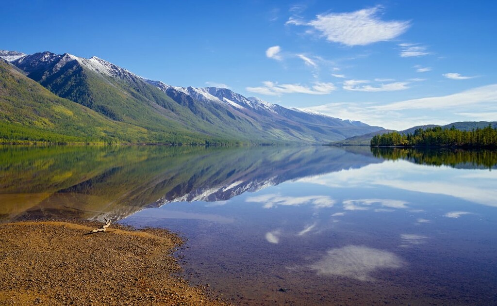
Despite some flat plains, the local topography is predominantly mountainous. If you look at the map of the region, you get the impression of a real amphitheatre. The northern part is lined with mountain ranges which are like massive rows stretching in one direction: from south-east to north-west. The middle part is occupied by the hills, while the southern part is like a stage made of the vast steppe plains.
The region can boast of 65 ranges with BAM Peak (3,073 m) being the highest point. The longest mountain range stretching for as much as 700 km is the Yablonovy Range. There are 50 lowland areas in the region, the lowest being the Amur River Valley (292 m).
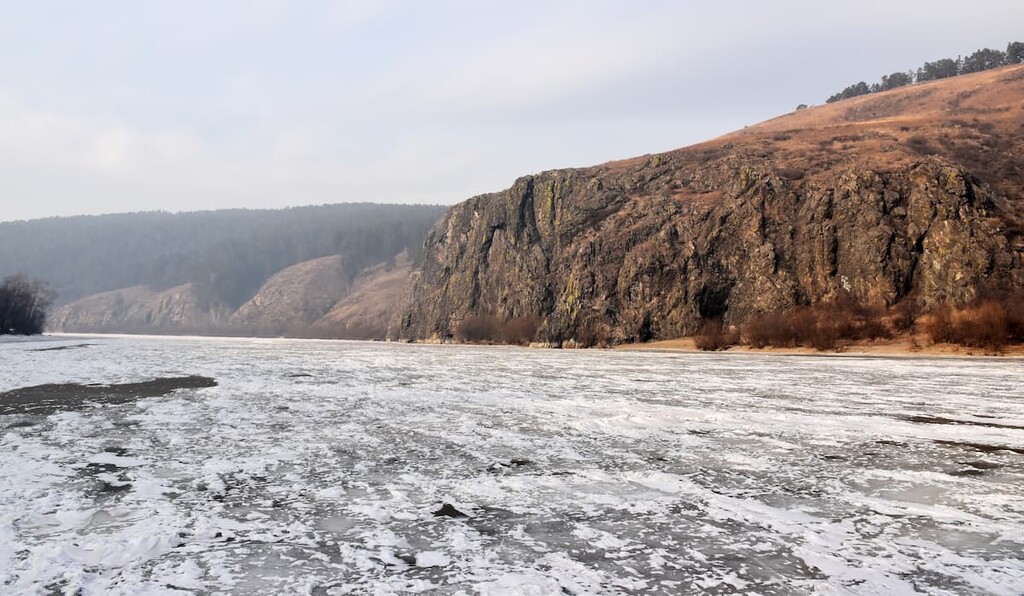
There are over 40,000 waterways in the Zabaikalye, most of which are small rivers and brooks less than 25 km long. The largest rivers are the Ingoda, Khilok, Shilka, Chikoi, Onon and Argun.
The territory is unique as it feeds the three major Asian rivers at once: the Lena, the Amur and the Yenisei (via the Selenga and Baikal).
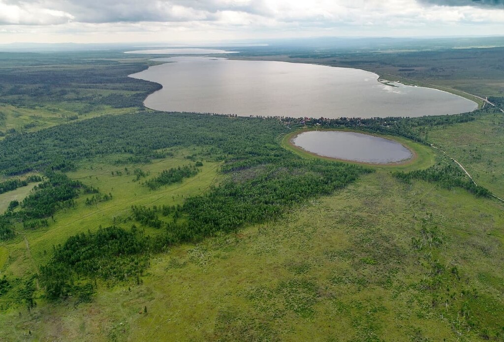
The great groups of lakes here are the Torey, Ivano-Arakhleisky and Kuando-Charsky lakes. There are also many mineral springs, most of which are located in the steppes and midland taiga.
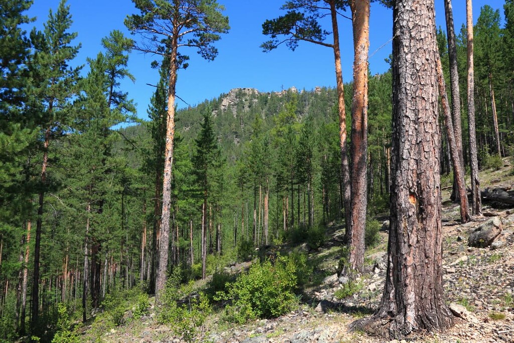
The flora features over 700-800 species. The predominant species are adapted to the cold and dry climate and a short vegetative period. Forests in the Zabaikalsky Territory are mainly located in the mountains and are concentrated in the northern and western parts of the region. They usually host several coniferous species sprinkled with occasional deciduous trees. You can see here Siberian cedar, Siberian spruce, Daurian larch, common pine, Siberian fir, aspen and birch. Mixed forests are dominated by birch and coniferous forests by pine. Underbrush is represented by shrubs and herbs: low birch, mountain ash, Dahurian rhododendron, rose hips, black cotoneaster, licorice and meadowsweet. In the south of the region, the slopes are almost devoid of woody vegetation, only some are sparsely covered with shrubs (Siberian apricot, meadowsweet or field elm) and isolated specimens of trees. In the river valleys, there are bird cherry, hawthorn, laurel poplar and others. While in the northern part there are marshes with sedges growing on them, in the southern part there are no swamps at all. The region is home to many medicinal and fodder plants.
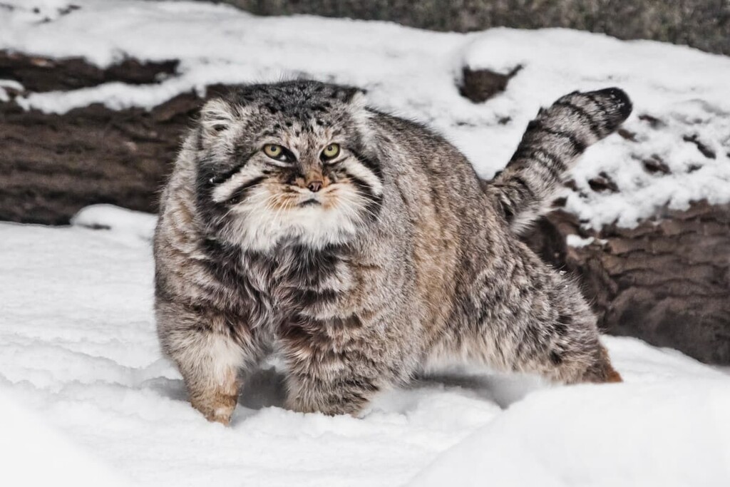
The fauna combines Siberian taiga and Mongolian steppe fauna with a few Manchurian species. Among mammals, there are more than 80 species including elk, Amur tiger, manul cat, Siberian roe deer, brown bear, Siberian musk deer, wild boar, fox, wolf, sable, squirrel, blue hare, Siberian musk deer, and Siberian spike. There are many different species of birds (cranes, geese, ducks, woodpeckers, etc.).
Some species are included in the Red Book of the Russian Federation, among them is the Pallas' cat (aka manul) which lives not only in the Transbaikal region but also inhabits the Altai Mountains, southeast Asia and Siberia. Scientists believe that manul is a very ancient animal, a contemporary of the saber-toothed tiger. Manul is also called Pallas's cat after the explorer Peter Simon Pallas (1741-1811) who discovered the animal. This mysterious species of wild cat is endangered. The zoos try to create all conditions for its reproduction in order to preserve the species and reintroduce it to the wild.
The development of Russia's trade relations with China are beneficial economically but have a detrimental effect on nature. Forests are cut on a massive scale, the sawmills and timber yards of the Chinese located in Transbaikal play a key role in the spread of illegal logging. And some of the logged timber which is less commercially valuable is dumped on the spot, partially getting into rivers during spring floods. At the same time, there is a discussion about locating Chinese pulp and paper mills in the Russian Federation, those plants are arguably not environmentally safe, and this has caused concern at the World Wildlife Fund. Increased poaching contributes to the decline of rare animal species.
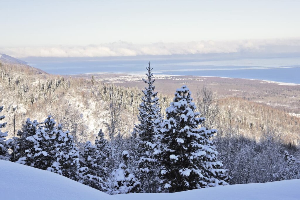
The climate of the Transbaikal Territory is severely continental with little precipitation falling mainly in summer and autumn. Winters are long, harsh and snowy. However, you can't find permanent snow caps in the mountains here because all the peaks are below the snow line. The average temperature in January is -19.7°С with up to -21°C in the mountains (-3F to -6F) in the south whereas the temperatures in the north can drop as low as -37.5°С (-36F). The absolute recorded minimum is -64°C (-83F).
Spring and autumn are short. Spring is cold, dry and windy, while autumn is warm. Summers are short and warm, sometimes even hot, with no precipitation in the first half of summer and humid spells in the second half. The average July temperature is +13°C (+70F) in the north and +20.7°C (+69 F) in the south (with up to +21°C (70 F) in the mountains). The absolute maximum recorded is +42 °C (+108 F).
The local climate is characterized by a long duration of sunshine throughout the year. The skies are almost always clear and sunny. In terms of the number of sunny days, Chita, the region's capital, is sometimes on a par with Sochi which is located in the subtropical climate of the Black Sea.
The region is famous for its highlands, beautiful mountains, gently rolling hills and precipitous cliffs. Some landmarks are difficult to access which attracts fans of extreme outdoor sports and mountain climbers, while others are easy to conquer and are a popular holiday destination. In winter, the two hotspots are Vysokogorie and Molokovka ski resorts.
The mountains of Southern Transbaikal Territory are said to resemble the Swiss Alps, with those picturesque pastoral landscapes, snow-covered mountain tops, which the locals call bald mountains for the lack of forests. Archaeological sites, Lamaist temples (datzans), rituals and cults – all this allows you to immerse in the culture of Transbaikal and get a feel of what the locals live by.
The Kodar Range stretches over 200 kilometers in the northern part of the Transbaikal Territory. Being an extension of the North-Muysky Range, the Kodar is part of the Stanovy Highlands. Don’t get it confused with the Stanovoy Range.
The Stanovy Highlands include the South Muisky, North Muisky, Kodar, Udokan, Kalar Ranges and large intermountain basins of the Baikal type at a height of 500-1000 m (Verkhneangarskaya, Muisko-Kuandinskaya, Verkhnecharskaya basins), the highest peak height of the Stanovy highlands is BAM (3,072m).
However, the Stanovoy Range (also known as the Outer Khingan) is a mountain range in the southern part of the Russian Far East. It stretches from the middle course of the Olyokma River to the headwaters of the Uchur River. It joins the Stanovy Highlands in the west and the Dzhugdzhur Mountains in the east. It is a watershed between the rivers of the Arctic and Pacific Oceans. Most of the range serves as a natural boundary between the Amur Region and Yakutia, while a small part of it is located on the territory of Khabarovsk Territory. The range is about 700 km long and 100-180 km wide, its maximum height is Skalisty Goletz – Rocky Bald Mountain (2,412m).
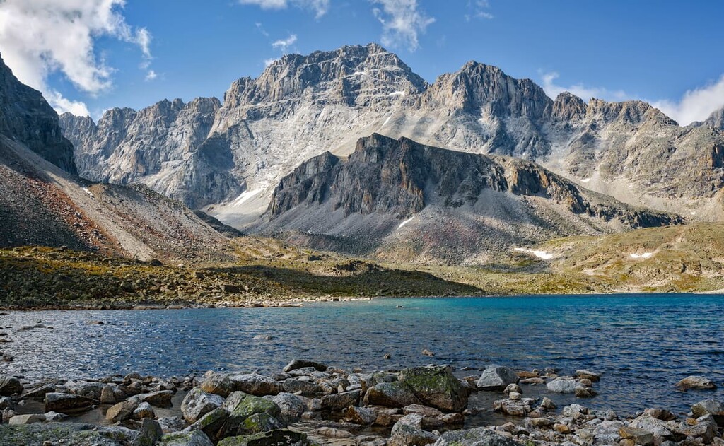
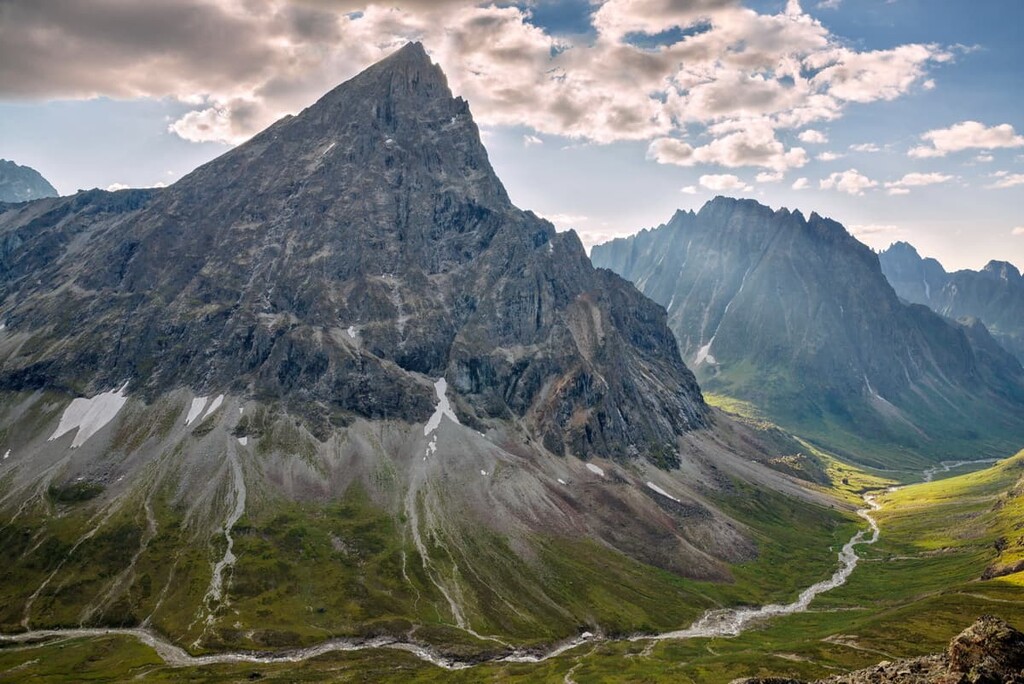
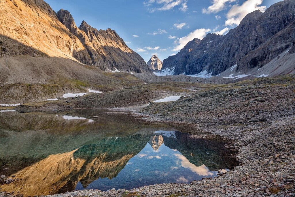
The Kodar Range is located almost 600 kilometers from Chita. It has the highest point of Transbaikal Territory – BAM Peak (3,072.6m). Distinct alpine relief distinguishes the Kodar from Siberian plateaus and midlands. In the Evenk language (the tongue of the indigenous peoples) Kodar is translated as a steep rock or wall. And it is difficult to argue with this, although the range is formed by not very high mountains, their slopes are so steep and precipitous that sometimes they seem to go almost vertically into the sky.
There are no 3B passes on the Kodar, but there are some complicated 3A ones. Also, there are a lot of white spots for travelers, some peaks are still unconquered and don’t even have names. For example, there is the Snezhny Pass (3A, 2300m), but there is no information that anyone has actually gone the whole way through that pass even though many groups make radial exits to it from the side of the river Middle Sakukan on an easy gentle slope.
According to the relief and hiking conditions, the Kodar is divided into Western, Central and Eastern. The Western Kodar is the least explored by tourists, while the main hiking routes pass through the Eastern and Central Kodars because they are easy to pass. In winter, the most popular destination is the Central Kodar with good options for skiing and snowshoe walking.
It is worth noting that the climate here is sharply continental and in some ways even harsher than in the Far North, so the hike will not be easy. The higher into the mountains, the colder and more humid it gets. So, if in Novaya Chara, where usually all hiking trails start, it is hot summer, in the mountains it would feel like cold spring, which begins only in May, and autumn ends in September. In June, many lakes in the Kodar are still under the ice, flowers appear in July and are already in bloom in August, and in September there come frosts that bring along a windy snowy winter. In summer, drizzling rains are frequent for many hours in the mountains.
The Kodar Range is the only glaciation area in the region; it has about 40 discovered glaciers, the largest of which have their own names. The total area is approximately 19 sq.km. which is now decreasing due to global warming. The area is located 50km from Chara village.
Back in Joseph Stalin’s times (in 1949-1951), the Marble Gorge in the Central Kodar was used as a site for Soviet atomic bomb studies because they mined uranium here and transported it by planes. The project proved to be commercially unfeasible and was foiled even though it used prisoners’ labour, that is why the place was called Borlag for some time. Now you can see the remnants of the uranium mine and the prisoner’s shelters if you go there on a tour with an organized group.
With the development of BAM – the Baikal-Amur railroad, the Kodar Range became relatively easily accessible. The nearest settlements are Chara village and Novaya Chara railway junction. There are two long-distance trains: No. 75/76 Moscow - Tynda (runs every other day) and No. 97/98 Kislovodsk - Tynda (runs twice a week). From Moscow, both trains arrive at Novaya Chara in the morning.
Another option is to take the local Novaya Chara - Severobaikalsk train or Novaya Chara - Kuanda and Novaya Chara - Khani commuter trains ("bichevoz," as they are called here). These trains go three times a day and stop at each crossing. You can start the trek from any stop. It's much cheaper than getting to the starting point by car or all-terrain vehicle but it all depends on the route. Mind you though, there is no afternoon train on weekends.
You can drive along the road which is winding along the river Middle Sakukan to the entrance to the Marble Gorge (26 km from Chara Village). The road goes farther, but only a motorcycle can pass it. The dirt road leads to the destroyed bridge in the Marble Gorge, and then it turns into a hiking trail.
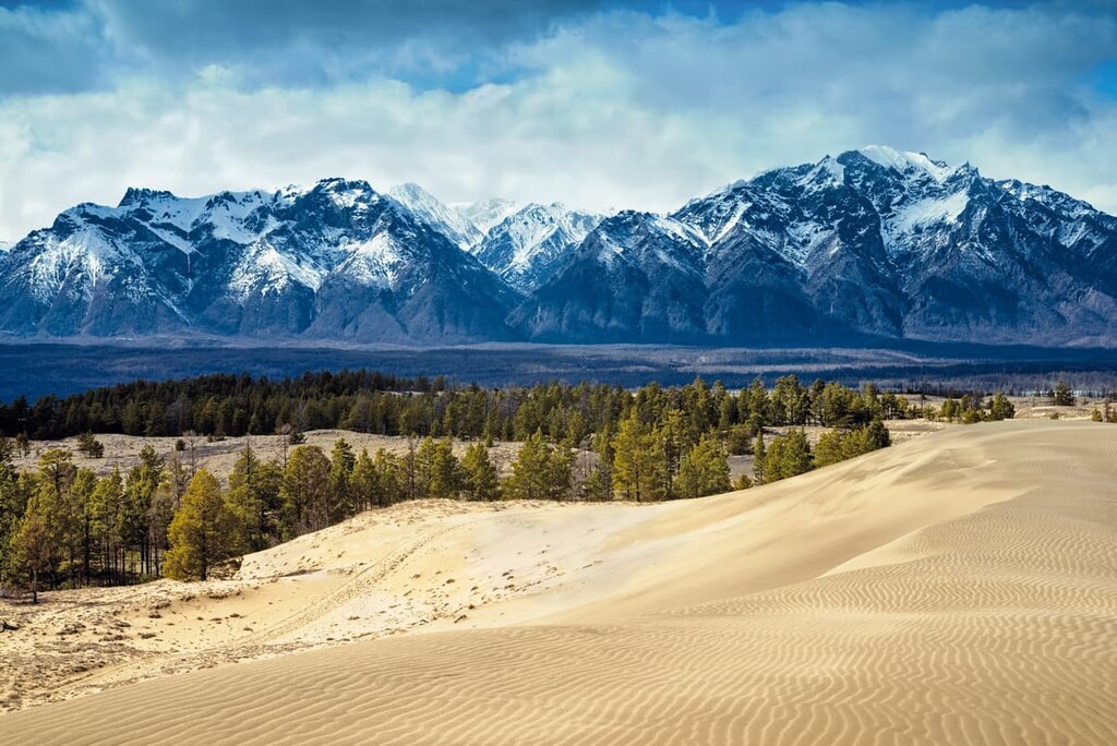
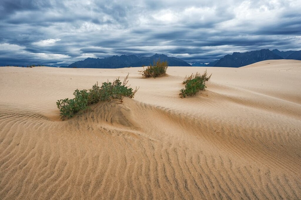
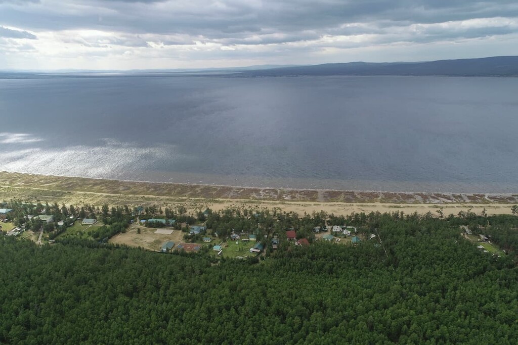
The Charsk Sands or Chara Sands Desert is located 5 km west of Chara village and 8 km northeast of Novaya Chara village, between the rivers Upper and Middle Sakukan. The Chara Sands are mind-blowing in their bizarreness. Their area is not small – approximately 45 sq.km. It looks like a common desert. But there comes a twist. Can you imagine seeing the warm yellow sand against a background of a cold blue ice and the green taiga? The tall sandy dunes (up to 80m high) and ridges suddenly open up in an oasis, yet not the one with palm trees, but the one with northern larches. High peaks surround the Sands, even in summer those peaks are covered with snow. Barchans end abruptly in swamps and lakes. In the southwest of the Sands, there is Lake Tayozhnoye, and in the northeast – Lake Alyonushka. Scientists believe that the desert appeared on the site of an ancient glacial lake, of which only small water fragments in the form of lakes scattered throughout the basin remain today.
Here you can relax, wash off the hiking fatigue, or just lie on the shore. You can go on a guided trip to the desert or drink some mineral water from the spring near Lake Alyonushka.
There are also the lesser-known Udokan and Kalar Ridges in the Kalar district. The Kalar Ridge used to be attributed to the Udokan. These are old smooth mountains with Udokan (2,603m) being the highest point (according to old maps it is 2,561m). The low altitude and relatively uncomplicated nature of the routes are compensated for by the unusual wildlife. Far fewer tourists walk here than on the Kodar. Accordingly, there is less garbage.
There are many mineral springs on the Kalar Ridge, there is even the so-called Kalar Geyser. It is located on the left bank of the unnamed tributary of the Eimnakh River opposite the mouth of the Chulbachi river, 2 km from the mouth of the tributary. The Eimnakh is the left tributary of the Kuanda River. There is a hot spring near the Purelag River, which flows into the Kuanda River as well. There are plenty of waterfalls both here and on Kodar.

The 700-km long Yablonovy Range stretches in the west of the region, parallel to the Chersky Range, separating the region from the Republic of Buryatia. It is the longest range of the region. It begins in the west in the left bank of the Khilok River, near the inflow of the Ungo River into it. The range stretches first sub-latitudinally then it turns northeast at the left bank of the Ingoda River at the confluence of the Vitim River and its right tributary, the Karenga River. At the head of the Chita River, it connects with the Chingikanskaya Ridge by a cofferdam (Chingikanskaya). and in the upper reaches of the Ungo River and in the area of the Arey Lake, there are junctions to the Malkhansky Range. In the section from the Chingikanskaya cofferdam (in the northeast) to Lake Arey (in the southwest) passes a part of the Great World Watershed between the Arctic and the Pacific Oceans. One of the peaks in this area, Mount Pallas, is a unique natural site because from its slopes the waters drain into 3 major rivers of Asia: the Yenisei, Amur and Lena. The maximum width of the Yablonovy Range reaches in the headwaters of the river Karenga (more than 80 km), the minimum width (more than 20 km) - a little north of the town of Chita. The prevailing altitudes are 1200-1400 m, the highest point is Mount Kontalaksky Goletz (1,706m).

Despite a seemingly obvious name in the Russian language - Yablonovy, the toponym has nothing to do with apples. The range is cut by several wide valleys, so the Buryats, the natives of these places, call this ridge Yaablan (Yablenni) dabaan, which can be translated as "convenient or passable pass". Nowadays it is believed that the name of the range was given by the Russians pioneers who, slightly distorted the name for ease of pronunciation and made it Yablonoy but as a result of this transformation, the meaning of the name has completely changed - from a ridge with comfortable passes it turned into a ridge with apple trees.
Actually, there do grow trees whose fruit are reminiscent of apples, but they are not actually apple trees.
Mount Pallas (1,236m) is a truly unique place on our planet because it is the Great watershed where the three largest rivers, the Amur, the Lena and the Yenisei, come from. It is in this place, called the Great Source, that two parts of the continent naturally separate, one collects water for the Arctic Ocean and the Atlantic, whereas the other feeds the Indian and Pacific Oceans. Mount Pallas is named after the famous explorer and traveller Peter Simon Pallas. The mountain is popular not only among tourists but also among pilgrims. Located about 35 kilometres from Chita, this world-class attraction can so far only be reached by a walking tour group.
The Yablonovy Range features another wonder – Mount Saranakan. It is a two-top mountain located about 75 km from Chita divided by the valley of the Kumakhta River into Mount Saranakan (or Big Saranakan, 1,578m) and Small Saranakan (1,579m). Yes, you see it right, the Big one is lower than the Small one. Big Mount Saranakan is a natural monument. Saranakan means a double-headed bald mountain. Mount Saranakan is a paleo volcano formed by lava. It is popular among sportsmen who arrange competitive climbing.
Titov’s Hill is actually a low-rise mountain named after the ethnographer and archaeologist E. Titov. It is located about 10 km southwest of the centre of Chita, near the confluence of the Ingoda and Chita Rivers. The Buryat name Airalzhan-khatan is common among the locals, it honours the shamaness Khalyukhan. The mountain is an extinct volcano rising 1 km a.s.l. It contains many archaeological treasures: fragments of ancient settlements, tools, animal remains, petroglyphs of ancient people.
The caves consist of two karst caves: the Dry and the Wet. They are the largest caves in the region. Their total length is 150-160m. It is advisable to visit them as part of guided tours and with appropriate equipment.
The Sukhotino Rocks are a sight to behold. These high granite cliffs with steep precipices are not only a natural phenomenon, but also an archaeological monument preserving ancient artefacts in their vicinity. They are located in the suburbs of Chita, on the banks of the Ingoda River and are extremely popular with climbers and fishermen.
The Smolenka Сliffs rise at the headwaters of the Smolenka River, 12 km northeast of Chita. They are a perfect example of picturesque weathering. Ancient rock paintings have also been found here.
The famous Dvortsy Cliffs (or Courtyards Cliffs) are located on the outskirts of Chita. The rocky ridges, representing outlandish forms of weathering, flank the valley of the Kadala River which flows into Lake Kenon. Sadly, the vegetation of the cliffs is now suffering from forest fires and extensive logging. The name comes from a folk term for a courtyard. The name has been used since ancient times to denote an area enclosed by mountains where wild animals were hunted. A tourist route from Chita to Lake Arakhley passes by the Dvortsy Cliffs and crosses the Yablonovy Range on the way.
Situated 20 km from Chita and just 2 km from Zabaikaletz Village, Mount Aracha (1,171 m) is a popular destination not only among tourists but also among climbers who like to train here. You can enjoy a beautiful panorama of part of the Yablonovy Range and the outskirts of Chita from the top of Mount Aracha.
The 1,120-metre peak is located in the valley of the Molokovka River about 5 kilometres from Chita. Its name Chyortovy (Devil's Peak) most likely comes from its inaccessibility for tourists because there are many obstacles on the way to the peak: dense forest and bushes, placers of huge boulders, lack of roads. But those who reach the peak can enjoy unforgettable views of Chita as well as the Ingoda and Molokovka Rivers. There are various legends and beliefs running about this mountain. It is considered to be forbidden not only to swear but even to talk loudly here, you also must not litter or break trees. The mountain is supposedly guarded by the spirit of the taiga, and it can punish those who disturb the peace.

Large areas in the Transbaikal Region are under state protection to ensure the conservation of flora and fauna. Visiting protected areas will require a permit obtained in advance.
The Aginsky Steppe Nature Reserve is located in the confluence of the Onon and Aga Rivers in the Aginsky district of the Transbaikal Territory. Its main part is a hilly plain and if you move to the intermountain depressions, you will find numerous small salt lakes. You can see a natural monument called Togon-Shuluun (Rock Pot), popularly called Genghis Khan's Cup. The Rock is considered sacred and is worshipped by the locals.

The Daursky Nature Reserve is located on the border with Mongolia and China, in the south of the Territory. The main site is the Torey Lakes, which are the largest in the region. This is the only habitat of the Mongolian gazelle in Russia. The granite remnants of the Adun-Chelon are another local attraction.
The Kodar National Park covers mountain taiga forests along the banks of the two rivers – the Chary and Vitim – and the Kodar mountain range. Here you can visit volcanoes, glaciers, the famous Charsk Sands Desert, numerous lakes (about 570 of them), mineral springs and other interesting natural sites.
The Kodar National Park was established on 08 February 2018 to protect over 350 species of plants, 47 species of mammals, more than 150 species of birds, 23 species of fish, 2 species of amphibians and more than 350 species of insects, most of them are in the Red Books of Russia and the Transbaikal Territory. You have to obtain a permit to visit the area, it can be done via the internet on the park’s official webpage.
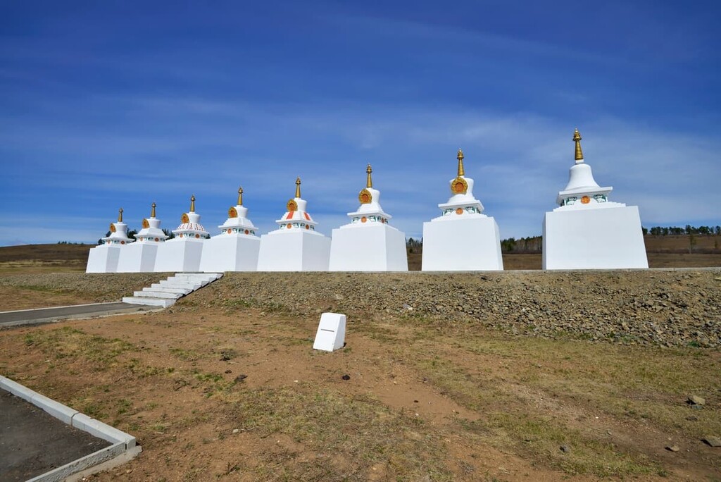
Located about 210 km from Chita, the Alkhanai National Park is a kind of a hub for preserving geological natural wonders. Its borders run along the Daursky and Mogoituisky mountain ranges. The most striking feature of the park is the forest-covered Alkhanai Mountain Range. This is a natural monument and one of the main Buddhist sanctuaries. Alkhanai is different from other national parks of Russia because here nature and manmade shrines exist in perfect unity. There are over 20 Buddhist shrines, some of them bear ancient petroglyphs. In the park you can relax, enjoy the beauty of the local nature, recover in the healing springs and feel the spirit of Buddhism.
The territory of the Sokhondin Nature Reserve occupies southern Transbaikal Territory, in the vicinity of the Sokhondo mountain range. There are steppe zones, mountain tundra and forests, as well as many mineral springs and glacial lakes. The world's watershed runs through its protected area.
The Chikoi National Park can be found at the head of the Chikoi River. It also has a fair share of its natural wonders, the most interesting of which is Lamsky Gorodok. It is an array of freestanding rocks of surprising shapes.
The Transbaikal Territory is rich in lakes and springs. Among the most popular are the Ivano-Arakhleisky lake system near Chita. Among them is Lake Arey which is surrounded by forests and alpine glades. At the bottom of the lake is mud with healing properties, the water is oxygenated, contains iodine, silver and other beneficial substances, and there are several springs.
Lake Arakhley is one of the largest lakes in Russia, its length is 11 km, depth is up to 20 m. There are picturesque shores, sandy and sandy-pebbly beaches. The lake is famous for its year-round fishing. On the coast, there are recreation centres, camps, and Preobrazhenka and Tasey villages.
Lake Shakshinskoye, 40 km from Chita in the Arakhleisky Nature Reserve, is the second largest lake after Lake Arakhley. It also has some cozy nooks to relax on the shore.
The Molokovka Spring is famous for its numerous mineral waters, so many springs, and so many unique chemical compounds you can find. It was discovered in the valley of the Molokovka river, not far from Chita, back in the 19th century. A balneological resort, known far beyond the borders of the region, was also founded there.
The place to start your awesome adventures in the Transbaikal region is Chita, the capital. There are several ways to get to this wonderful city, the most convenient is by air. Planes arrive at the international airport Kadala which is located 18 km from the centre of Chita. Take a bus or a shuttle bus to the city. Alternatively, you can get to Chita by plane.
Chita city, pronounced almost like the famous animal cheetah but with the stress on the second syllable, was founded in 1653 as a winter settlement on the banks of the Ingoda River at its confluence with Chita River. It was then known as Chita Ostrog (Dungeon). Later, in 1851, Chita received a city status, and in the 20th century it became the centre of the Chita Region.
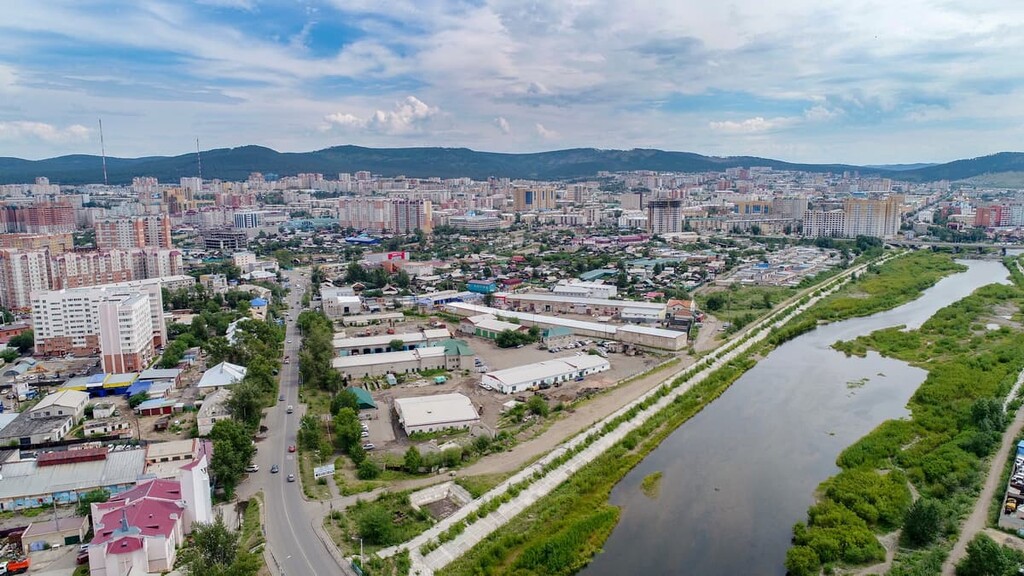
There are several interesting landmarks worth paying a visit to. The architecture is really fascinating since you can see very ethnic edifices like bhuddist temples called datsuns or datsans neighbouring European elegant mansions or Soviet-style blocks.
The most prominent buildings are probably the Chita Datsan and Shumovsky Palace; these two buildings have been included in the list of federal monuments protected by the government.
The large Buddhist monastery, the Chita Datsan, was inaugurated in 2010. It is not just a temple but actually a university where Buryat Buddhists are educated.
The Palace is a building you would not expect to see in the Eastern Siberia. Being built in 1912, Shumovsky Palace surprises and delights with its beauty and elegance. Unfortunately, you cannot see the splendor of the late Russian Empire aristocracy because you cannot get in the Palace. According to the Soviet tradition, the Palace houses the regional department of the Federal Security Bureau (former KGB headquarters). On the other hand, this is what helps to maintain the Palace in mint condition.
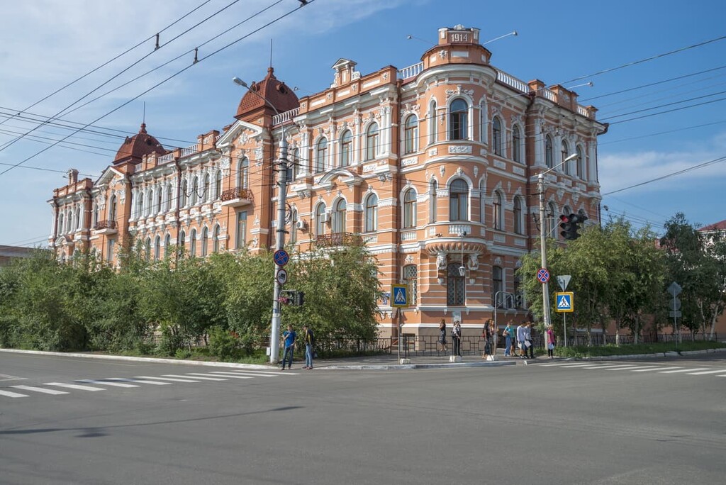
The Palace was commissioned by millionaire gold merchants, the Shumovs brothers. The order was to create a rich and lavish place. The chief city architect of the time, Mosashvili, went to great lengths. He is said to have blended the Baroque and Classicism styles and did most of the budget allocated to the construction. However, there is another more plausible version about the Palace architectural design origin. One study suggests that one of the Shumovs bought the project which took a grand prize at the World Exhibition in Paris. Anyway, the palace was finished within a year, truly speedy work it must have been, yet, it was considered unfinished since the wall opposite the main facade remained only half-painted due to the outbreak of World War I.
Even though you cannot walk the rooms and corridors of the Palace, you can still have a sneak peek at how things are in there. There is a small Museum of the history of the KGB Department, where you can see a replica of the 1930s office of a kgb-officer (they were usually called Chekist) with the original furniture. Also in the museum there is a 1:100 scale model of the building, created by a descendant of the Shumov family and an employee of the department.
Address: 84 Lenin Street.
The museum is located on the corner of Lenin Street and Pauline Osipenko Street, near the park Odora.
Walking around the city, you can visit Lenin Square and Odora Park which houses an exhibition of military equipment.
On the central square is the main Orthodox church in the city, the Kazan Cathedral. Speaking of religious buildings, Chita hosts the only cathedral Mosque in the Transbaikal Region.
If you are into entertainment, visit the Zabaikalsky Krai Drama Theatre, Zabaikalsky State Puppet Theatre Tridevyatoe Tsarstvo (the name can be loosely translated as the far-far-away kingdom), Theatre of National Culture Zabaikalskie Uzory, and Municipal Folklore Theatre Zabaikalye.
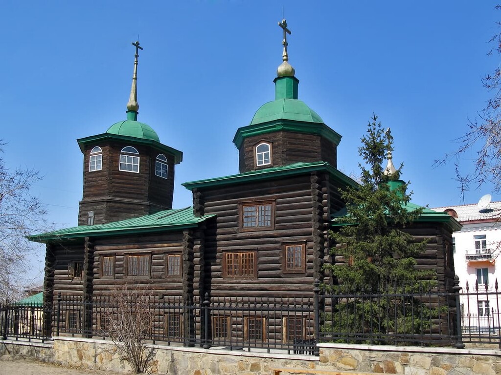
There are many museums in Chita open to the public. Among the most popular ones are the Geological Museum, the Local Lore Museum and the Museum of Decembrists, which is located in a wooden building, the former Mikhailo-Arkhangelsky Church. This building is the oldest in Chita and is a monument of wooden church architecture.
There is also a zoo and the Zabaikalsky Botanical Garden in Chita.


